Lanouaille
Lanouaille | |
|---|---|
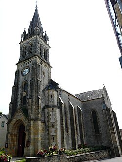
 The church in Lanouaille | |
| Coordinates: 45°23′34″N 1°08′20″E / 45.3928°N 1.1389°E | |
| Country | France |
| Region | Nouvelle-Aquitaine |
| Department | Dordogne |
| Arrondissement | Nontron |
| Canton | Isle-Loue-Auvézère |
| Intercommunality | Isle-Loue-Auvézère en Périgord |
| Government | |
| • Mayor (2020–2026) | Jean-Christophe Boulanger[1] |
Area 1 | 23.78 km2 (9.18 sq mi) |
| Population (2022)[2] | 938 |
| • Density | 39/km2 (100/sq mi) |
| Time zone | UTC+01:00 (CET) |
| • Summer (DST) | UTC+02:00 (CEST) |
| INSEE/Postal code | 24227 /24270 |
| Elevation | 198–234 m (650–768 ft) (avg. 300 m or 980 ft) |
| 1 French Land Register data, which excludes lakes, ponds, glaciers > 1 km2 (0.386 sq mi or 247 acres) and river estuaries. | |
Lanouaille (French pronunciation: [lanwaj]; Limousin: La Noalha) is a commune in the Dordogne department in Nouvelle-Aquitaine in southwestern France. The departmental road D704 (Sarlat-Limoges) passes through the town.
History
[edit]Lanouaille (la nouvelle - new) is a relatively new commune created from parts of the areas of Savignac-Lédrier and Dussac. It owes its development to its location on the road from Sarlat to Limoges via Saint Yrieix and Montignac (D704) and to its status as seat of the canton until 2015 (before 1801 Dussac was the seat of the canton).
Population
[edit]| Year | Pop. | ±% |
|---|---|---|
| 1962 | 965 | — |
| 1968 | 1,025 | +6.2% |
| 1975 | 1,026 | +0.1% |
| 1982 | 1,006 | −1.9% |
| 1990 | 976 | −3.0% |
| 1999 | 966 | −1.0% |
| 2008 | 988 | +2.3% |
See also
[edit]References
[edit]- ^ "Répertoire national des élus: les maires" (in French). data.gouv.fr, Plateforme ouverte des données publiques françaises. 13 September 2022.
- ^ "Populations de référence 2022" (in French). The National Institute of Statistics and Economic Studies. 19 December 2024.
Wikimedia Commons has media related to Lanouaille.


 French
 Deutsch


