Lipová (Děčín District)
Lipová | |
|---|---|
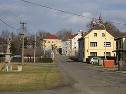
 Centre of Lipová | |
| Coordinates: 51°0′40″N 14°21′37″E / 51.01111°N 14.36028°E | |
| Country | |
| Region | Ústí nad Labem |
| District | Děčín |
| First mentioned | 1344 |
| Area | |
• Total | 12.83 km2 (4.95 sq mi) |
| Elevation | 366 m (1,201 ft) |
| Population (2024-01-01)[1] | |
• Total | 579 |
| • Density | 45/km2 (120/sq mi) |
| Time zone | UTC+1 (CET) |
| • Summer (DST) | UTC+2 (CEST) |
| Postal code | 407 81 |
| Website | www |
Lipová (until 1948 Haňšpach; German: Hainspach) is a municipality and village in Děčín District in the Ústí nad Labem Region of the Czech Republic. It has about 600 inhabitants.
Administrative parts
[edit]The village of Liščí is an administrative part of Lipová.
Geography
[edit]Lipová is located about 29 kilometres (18 mi) northeast of Děčín and 44 km (27 mi) northeast of Ústí nad Labem. It lies in the salient region of Šluknov Hook, on the border with Germany. It borders the German municipalities of Steinigtwolmsdorf and Sohland an der Spree. It is situated in the Lusatian Highlands. The highest point of Lipová is the hill Ječný vrch at 502 m (1,647 ft) above sea level. The brook Liščí potok originates here and flows across the municipality. The village of Lipová lies on the shore of the Zámecký Pond; the second notable pond in the municipal territory is Solandský.
History
[edit]The first written mention of Haňšpach is from 1344, when the village was owned by the Berka of Dubá family as part of the Tolštejn estate.[2]
In 1948, the name of the municipality was changed from Haňšpach to Lipová.[3]
Demographics
[edit]
|
|
| ||||||||||||||||||||||||||||||||||||||||||||||||||||||
| Source: Censuses[4][5] | ||||||||||||||||||||||||||||||||||||||||||||||||||||||||
Economy
[edit]The municipality suffers from its location in Šluknov Hook at the periphery of the Czech Republic. The region has persistently high unemployment rate, low supply of services and poor quality of healthcare.[6]
Transport
[edit]There are no railways or major roads passing through the municipality. On the Czech-German border is the road broder crossing Lipová / Sohland.
Sights
[edit]
The main landmark of Lipová is the Church of Saints Simon and Jude, built in the Baroque style in 1691–1695. The tower was added in 1781.[7]
Lipová Castle was built in 1736–1738. Today it is a ruin. It is surrounded by a park.[8]
References
[edit]- ^ "Population of Municipalities – 1 January 2024". Czech Statistical Office. 2024-05-17.
- ^ "Z historie obce" (in Czech). Obec Lipová. Retrieved 2022-12-30.
- ^ "Vyhláška č. 22/1949 Sb". Zákony pro lidi (in Czech). Retrieved 2023-11-18.
- ^ "Historický lexikon obcí České republiky 1869–2011" (in Czech). Czech Statistical Office. 2015-12-21.
- ^ "Population Census 2021: Population by sex". Public Database. Czech Statistical Office. 2021-03-27.
- ^ "Obrazy zdravotnictví na Šluknovsku: dostanete-li mrtvičku, můžete se leda modlit" (in Czech). Deník Referendum. 2021-02-10. Retrieved 2022-12-30.
- ^ "Kostel sv. Šimona a Judy" (in Czech). National Heritage Institute. Retrieved 2022-12-30.
- ^ "Zámek" (in Czech). National Heritage Institute. Retrieved 2022-12-30.


 French
 Deutsch

