
 French
 Deutsch
List of Indian states and union territories by highest point

This is the alphabetical list of the highest points of the Indian states and union territories.
States
[edit]Union territories
[edit]| Union Territory | Peak | Range/Region | Height | Coordinates | Source | |
|---|---|---|---|---|---|---|
| In m | In ft | |||||
| Ladakh | Saltoro Kangri | Saltoro Mountains section of Karakoram | 7,742 | 25,400 | 35°23′56″N 76°50′56″E / 35.399°N 76.849°E | Saltoro Kangri lies on the Actual Ground Position Line between India and Pakistan on the Siachen Glacier. It is the highest peak in the Saltoro Mountains. The highest peak claimed by India as part of Ladakh is K2 which has the elevation of 8,611 m (28,251 ft). K2 is located in the Pakistan-administered territory of Gilgit-Baltistan.[31][32][33] |
| Jammu and Kashmir | Nun Peak | Western Himalayas | 7,135 | 23,409 | 33°58′51″N 76°01′14″E / 33.9809°N 76.0205°E | [34] |
| Andaman and Nicobar Islands | Saddle Peak | North Andaman Island | 732 | 2,402 | 13°09′31″N 93°00′21″E / 13.1586°N 93.0058°E | [35] |
| Chandigarh | Unnamed point near Khuda Ali Sher Village | Sivalik Hills | 479 | 1,572 | 30°46′21″N 76°49′13″E / 30.7724°N 76.8204°E | Located on the border between Punjab and Chandigarh.[citation needed] |
| Dadra and Nagar Haveli and Daman and Diu | Unnamed point near Bedpa Village | Western Ghats | 465 | 1,526 | 20°04′49″N 73°12′21″E / 20.0802°N 73.2057°E | Located in Dadra and Nagar Haveli District on the border between Dadra and Nagar Haveli and Daman and Diu and Maharashtra.[citation needed] |
| Delhi | Deheri | Delhi Ridge section of the Aravalli Range | 315 | 1,033 | 28°24′39″N 77°12′13″E / 28.4108°N 77.2037°E | Located in South Delhi District on the border between Delhi and Haryana.[citation needed] |
| Puducherry | Unnamed point near Chalakara Village | West Coast Hillocks | 67 | 219 | 11°43′06″N 75°31′54″E / 11.7183°N 75.5317°E | Located in Mahé District on the border between Puducherry and Kerala.[citation needed] |
| Lakshadweep | Unnamed point | Agatti Island | 15 | 49 | ||
Gallery
[edit]-
 Kangchenjunga (8,586 m)
 -
 Nanda Devi (7,816 m)
 -
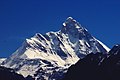
 Saltoro Kangri (7,742m)
 -
 Nun Kun (7,135 m)
 -
 Kangto (7,090 m)
 -
 Reo Purgyil (6,816 m)
 -
 Sandakphu (3,636 m)
 -
 Anamudi (2,695 m)
 -
 Guru Shikhar (1,722 m)
 -
 Kalsubai (1,646 m)


.jpg)


See also
[edit]- List of hill stations in India
- List of mountains in India
- List of mountain passes of India
- List of the tallest statues in India
- List of tallest buildings in India
- List of tallest structures in India
- Tourism in India
References
[edit]- ^ "Kangchenjunga - Peakware". Archived from the original on 2009-02-20. Retrieved 2008-12-27.
- ^ "Nanda Devi - Peakware".
- ^ "Saramati". Peakbagger.com.
- ^ "Sandakphu". Archived from the original on 2008-12-25.
- ^ "Hills Of Manipur". Archived from the original on 2013-03-23.
- ^ "Manipur Tourism District:Senapati". Archived from the original on 2017-04-03. Retrieved 2014-10-14.
- ^ "Anai Mudi". Peakbagger.com.
- ^ "A Beautiful Green Hills". Archived from the original on 2007-09-29.
- ^ "Phawngpui, Mizoram". Archived from the original on 2009-05-02. Retrieved 2008-12-27.
- ^ The Rough Guide to India. Rough Guides. 1 October 2013. pp. 963–. ISBN 978-1-4093-4267-0.
- ^ "Assam Hills". Birdlife International.
- ^ Ganesh Prabhu (2014-03-19). "Udupi-Chikmagalur: A constituency that's beset by problems". The Hindu.
- ^ "Guru Shikhar, Mount Abu". Archived from the original on 2009-04-10.
- ^ The Geography of India: Sacred and Historic Places
- ^ The britannica Quiqmaster
- ^ "Deomali Peak in Koraput".
- ^ "Kalsubai". Archived from the original on 2011-07-22. Retrieved 2008-12-27.
- ^ Bijender K Punia (1994). Tourism Management: Problems and Prospects. APH Publishing. pp. 21–. ISBN 978-81-7024-643-5.
- ^ "Parasnath". Archived from the original on 2005-10-18.
- ^ M.S. Kohli (2002). Mountains of India: Tourism, Adventure and Pilgrimage. Indus Publishing. p. 39. ISBN 978-81-7387-135-1.
- ^ छत्तीसगढ़ के सर्वोच्च शिखर गौरलाटा पर 5 वर्ष की एडविना कांत
- ^ "National Mineral Development Corporation, Dantewada district, Chhattisgarh". Archived from the original on 2017-03-01. Retrieved 2014-11-06.
- ^ Bailadila Hills, Dantewada district, Chhattisgarh
- ^ Background Information about the State of Gujarat Archived 2017-08-20 at the Wayback Machine, dgfasli.nic.in
- ^ "The tiger in the tale". The Times of India. 2011-12-12.
- ^ "Gazetteer Rupnagar". Archived from the original on 2016-07-16. Retrieved 2014-09-25.
- ^ "Wikimapia - Doli Gutta (965m) - Telangana Chhattisgarh border. Possibly highest point in Telangana".
- ^ "Highest Peaks in India".
- ^ "Peakbagger - Betalongchhip, India".
- ^ Fort Someshwar, West Champaran district, Bihar
- ^ "Saltoro Kangri, Pakistan/India". Peakbagger.com.
- ^ "Top 10 highest Himalaya mountain peaks in India".
- ^ "Top 10 highest peaks of India".
- ^ "Nun, India". Peakbagger.com.
- ^ "Saddle Peak -- Britannica".