| Name | Address | Coordinates | Government recognition (CRHP №) |  | Image |
| Fannystelle School |
Grey MB | 49°44′42″N 97°46′39″W / 49.745°N 97.7776°W / 49.745; -97.7776 (Fannystelle School) | Grey municipality (6589) | | 
Upload Photo |
| Convent of the Sisters of the Holy Names of Jesus and Mary | 432 Joubert Street North
St. Jean Baptiste MB | 49°26′42″N 96°59′31″W / 49.445°N 96.992°W / 49.445; -96.992 (Convent of the Sisters of the Holy Names of Jesus and Mary) | Manitoba (3857) | |
Upload Photo |
| Sacred Heart of Jesus Roman Catholic Church | 37 Church Avenue
Grey MB | 49°44′44″N 97°46′48″W / 49.7456°N 97.78°W / 49.7456; -97.78 (Sacred Heart of Jesus Roman Catholic Church) | Grey municipality (8495) | | 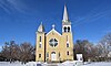 |
| Grace Evangelical Lutheran Church | 408 Main Street
Lakeview MB | 50°23′04″N 98°40′32″W / 50.3844°N 98.6755°W / 50.3844; -98.6755 (Grace Evangelical Lutheran Church) | Lakeview municipality (6756) | |
Upload Photo |
| Moffatt Barn |
Lakeview MB | 50°15′05″N 98°43′42″W / 50.2514°N 98.7283°W / 50.2514; -98.7283 (Moffatt Barn) | Lakeview municipality (8156) | |
Upload Photo |
| Arden Mound and Camp Site |
Lansdowne MB | 50°14′00″N 96°15′15″W / 50.2333°N 96.2542°W / 50.2333; -96.2542 (Arden Mound and Camp Site) | Manitoba (6974) | |
Upload Photo |
| Tenby School | Main Street
Lansdowne MB | 50°30′03″N 99°07′58″W / 50.5008°N 99.1329°W / 50.5008; -99.1329 (Tenby School) | Lansdowne municipality (5774) | |
Upload Photo |
| Scott House |
Lansdowne MB | 50°24′37″N 99°21′18″W / 50.4102°N 99.355°W / 50.4102; -99.355 (Scott House) | Lansdowne municipality (7013) | |
Upload Photo |
| Austin Elevator | Manitoba Agricultural Museum, Provincial Highway 34
North Norfolk MB | 49°55′31″N 98°56′48″W / 49.9254°N 98.9466°W / 49.9254; -98.9466 (Austin Elevator) | North Norfolk municipality (20205) | |  |
| MacGregor Canadian Pacific Railway Water Tower | Manitoba Agricultural Museum, Provincial Highway 34
North Norfolk MB | 49°55′31″N 98°56′45″W / 49.9252°N 98.9458°W / 49.9252; -98.9458 (MacGregor Canadian Pacific Railway Water Tower) | North Norfolk municipality (20206) | | 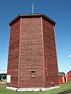 |
| Holland Emmanuel Historical Church | 114 Barr Street
Victoria MB | 49°35′46″N 98°52′52″W / 49.5962°N 98.8812°W / 49.5962; -98.8812 (Holland Emmanuel Historical Church) | Victoria municipality (19369) | | 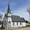 |
| Mahon Home |
Victoria MB | 49°35′42″N 98°58′50″W / 49.595°N 98.9806°W / 49.595; -98.9806 (Mahon Home) | Victoria municipality (6480) | |
Upload Photo |
| Young House | SW 27-7-12 W
Victoria MB | 49°35′29″N 99°01′30″W / 49.5915°N 99.0249°W / 49.5915; -99.0249 (Young House) | Victoria municipality (5773) | |
Upload Photo |
| Qually Brothers Store | 48 Qually Road
Cartier MB | 49°53′N 97°38′W / 49.88°N 97.63°W / 49.88; -97.63 (Qually Brothers Store) | Cartier municipality (9953) | |
Upload Photo |
| St. Paul's Anglican Church | 4813 PTH 26
St. François Xavier MB | 50°02′59″N 97°50′13″W / 50.0498°N 97.8369°W / 50.0498; -97.8369 (St. Paul's Anglican Church) | St. François Xavier municipality (2735) | |
Upload Photo |
| Warkentin Blacksmith Shop | 2172 PTH 26
St. François Xavier MB | 49°57′50″N 97°37′42″W / 49.9639°N 97.6284°W / 49.9639; -97.6284 (Warkentin Blacksmith Shop) | St. François Xavier municipality (2739) | |
Upload Photo |
| Grey Nuns' Convent | 1060 Highway 26
Cartier MB | 49°54′45″N 97°32′21″W / 49.9124°N 97.5393°W / 49.9124; -97.5393 (Grey Nuns' Convent) | Cartier municipality (3885) | |
Upload Photo |
| Galloway Bros Department Store | 37 Morris Avenue
Gladstone MB | 50°13′42″N 98°57′00″W / 50.2283°N 98.9499°W / 50.2283; -98.9499 (Galloway Bros Department Store) | Manitoba (3490) | |
Upload Photo |
| Smith/Arthur Farm Elevator |
Gladstone MB | 50°13′19″N 98°58′31″W / 50.2219°N 98.9752°W / 50.2219; -98.9752 (Smith/Arthur Farm Elevator) | Gladstone municipality (6892) | |
Upload Photo |
| Taylor House | 102 1st Street SW
Portage la Prairie MB | 49°34′52″N 98°10′25″W / 49.5811°N 98.1735°W / 49.5811; -98.1735 (Taylor House) | Portage la Prairie municipality (4505) | |
Upload Photo |
| Portage la Prairie Canadian Pacific Railway Station | 301 3rd Street NE
Portage la Prairie MB | 49°35′04″N 98°10′36″W / 49.5845°N 98.1768°W / 49.5845; -98.1768 (Portage la Prairie Canadian Pacific Railway Station) | Federal (4556, (15788),
Portage la Prairie municipality (4506) | |  |
| Poplar Point and District Memorial Rink | 39 Aspen Drive
Portage la Prairie MB | 50°01′54″N 97°35′02″W / 50.0317°N 97.5839°W / 50.0317; -97.5839 (Poplar Point and District Memorial Rink) | Portage la Prairie municipality (4900) | |
Upload Photo |
| St. Anne's Anglican Church |
Portage la Prairie MB | 50°02′33″N 98°01′27″W / 50.0426°N 98.0242°W / 50.0426; -98.0242 (St. Anne's Anglican Church) | Manitoba (5398),
Portage la Prairie municipality (5399) | |
Upload Photo |
| Flee Island Dakota Entrenchment |
Portage la Prairie MB | 50°03′36″N 98°05′25″W / 50.06°N 98.0904°W / 50.06; -98.0904 (Flee Island Dakota Entrenchment) | Manitoba (7303) | | 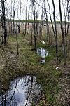
More images |
| St. Ambroise Dakota Entrenchment |
Portage la Prairie MB | 50°08′N 98°02′W / 50.13°N 98.04°W / 50.13; -98.04 (St. Ambroise Dakota Entrenchment) | Manitoba (7304) | |
Upload Photo |
| Macdonald Pioneer Cemetery |
Portage la Prairie MB | 50°03′48″N 98°28′09″W / 50.0633°N 98.4692°W / 50.0633; -98.4692 (Macdonald Pioneer Cemetery) | Portage la Prairie municipality (7754) | |
Upload Photo |
| St. Mary's la Prairie Anglican Church | 36 Second Street SW
Portage la Prairie MB | 49°58′21″N 98°17′36″W / 49.9726°N 98.2934°W / 49.9726; -98.2934 (St. Mary's la Prairie Anglican Church) | Manitoba (4297) | |
Upload Photo |
| Portage la Prairie Dominion Post Office | 97 Saskatchewan Avenue
Portage la Prairie MB | 49°58′21″N 98°17′11″W / 49.9725°N 98.2864°W / 49.9725; -98.2864 (Portage la Prairie Dominion Post Office) | Portage la Prairie municipality (5485) | |  |
| Portage la Prairie Land Titles Building | 103 3rd Street NE
Portage la Prairie MB | 49°58′27″N 98°17′06″W / 49.9743°N 98.285°W / 49.9743; -98.285 (Portage la Prairie Land Titles Building) | Manitoba (5848) | |
Upload Photo |
| Portage la Prairie Public Building National Historic Site of Canada | 55 Saskatchewan Avenue West
Portage la Prairie MB | 49°58′22″N 98°17′30″W / 49.9729°N 98.2918°W / 49.9729; -98.2918 (Portage la Prairie Public Building National Historic Site of Canada) | Federal (7543) | |
More images |
| McCowan House | 39 2nd Street SW
Portage la Prairie MB | 49°58′11″N 98°17′36″W / 49.9697°N 98.2934°W / 49.9697; -98.2934 (McCowan House) | Portage la Prairie municipality (8848) | |
Upload Photo |
| First Homestead in Western Canada National Historic Site of Canada | Highway 240, 1 mile north of Hwy 249 junction
Portage la Prairie MB | 50°03′45″N 98°17′08″W / 50.0625°N 98.2856°W / 50.0625; -98.2856 (First Homestead in Western Canada National Historic Site of Canada) | Federal (17541) | |
Upload Photo |
| Fort La Reine National Historic Site of Canada | 130 Yellowquill Trail
Portage la Prairie MB | 49°57′04″N 98°19′38″W / 49.9511°N 98.3272°W / 49.9511; -98.3272 (Fort La Reine National Historic Site of Canada) | Federal (17947) | | 
More images |
| Portage la Prairie Armoury | 143 Second Street
Portage la Prairie MB | 49°58′34″N 98°17′35″W / 49.9761°N 98.293°W / 49.9761; -98.293 (Portage la Prairie Armoury) | Federal (9512) | |
Upload Photo |
| Hill's Drug Store | 200 Saskatchewan Avenue East
Portage la Prairie MB | 49°35′N 98°10′W / 49.58°N 98.17°W / 49.58; -98.17 (Hill's Drug Store) | Portage la Prairie municipality (16350) | |
Upload Photo |
| Saint-Claude Gaol Museum | 5 Provincial Road & 240 N.
St. Claude MB | 49°39′54″N 98°20′42″W / 49.6651°N 98.3449°W / 49.6651; -98.3449 (Saint-Claude Gaol Museum) | St. Claude municipality (6429) | |
Upload Photo |
| Treherne United Church | 186 Boyne Street
Treherne MB | 49°37′41″N 98°41′50″W / 49.628°N 98.6972°W / 49.628; -98.6972 (Treherne United Church) | Treherne municipality (6735) | |
Upload Photo |

 French
 Deutsch

.JPG)
.JPG)


