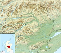
Loch Derculich
| Loch Derculich | |
|---|---|
 Frozen Loch Derculich | |
| Coordinates | 56°40′22″N 3°51′16″W / 56.6727°N 3.8545°W |
| Type | freshwater loch |
| River sources | Derculich Burn |
| Max. length | 0.804 km (0.500 mi)[1] |
| Max. width | 0.402 km (0.250 mi)[1] |
| Surface area | 39.9 ha (99 acres)[2] |
| Average depth | 25 ft (7.6 m)[1] |
| Max. depth | 70 ft (21 m)[1] |
| Water volume | 108,333,000 cu ft (3,067,600 m3)[1] |
| Shore length1 | 3.3 km (2.1 mi) [2] |
| Surface elevation | 367 m (1,204 ft)[2] |
| Max. temperature | 55 °F (13 °C) |
| Min. temperature | 47 °F (8 °C) |
| Settlements | Aberfeldy |
| 1 Shore length is not a well-defined measure. | |
Loch Derculich is a freshwater loch in central highlands of Scotland, in Perth and Kinross.[1][2] Loch Tummel is located three miles to the north.[3]
Habitation
[edit]Evidence of Shieling huts in two groups are visible from oblique aerial photography, that consist of two groups in either side of a gully on the South of Loch Derculich. A trackway runs to the SW of the huts. What may be a hut-circle lies beside a more modern track to the north-east of the huts.[4]
References
[edit]- ^ a b c d e f John, Murray; Lawrence, Pullar (1910). Bathymetrical Survey of the Fresh-Water Lochs of Scotland, 1897-1909 Lochs of the Tay Basin Volume II - Loch of Butterstone. National Library of Scotland: National Challenger Officer. p. 83. Retrieved 24 July 2018.
 This article incorporates text from this source, which is in the public domain.
 - ^ a b c d "Loch Derculich". British Lakes. Archived from the original on 24 July 2018. Retrieved 24 July 2018.
- ^ "Derculich, Loch". The Gazetteer for Scotland. School of GeoSciences, University of Edinburgh and The Royal Scottish Geographical Society. Retrieved 24 July 2018.
- ^ "Loch Derculich Hut Circle". Canmore National Record of the Historic Environment. Historic Environment Scotland. Retrieved 24 July 2018.


 French
 Deutsch