Medeho
Medeho مديهو | |
|---|---|
Town | |
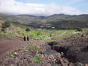
 Medeho and the mountains of Mabla | |
| Coordinates: 11°58′20″N 43°1′29″E / 11.97222°N 43.02472°E | |
| Country | |
| Region | Obock |
| Elevation | 690 m (2,260 ft) |
| Population | |
| • Total | 4,000 |
Medeho (Arabic: مديهو) is a town in the northeastern Obock Region of Djibouti. Medeho has one of the mildest climates in Djibouti, which is not always passable during the rainy season. The town is overlooked by Mabla Mountains, the fifth tallest mountain in Djibouti. As of 2016, the population of Medeho has been estimated to be 4,000. It is situated approximately 39 km (24 mi) west of Obock, the regional capital.
Overview
[edit]Nearby towns and villages include Tadjoura (42 km) and Obock (39 km).
Climate
[edit]Medeho has a hot semi-arid climate (BSh) in Köppen-Geiger system, with the influence of mountain climate.
| Climate data for Medeho | |||||||||||||
|---|---|---|---|---|---|---|---|---|---|---|---|---|---|
| Month | Jan | Feb | Mar | Apr | May | Jun | Jul | Aug | Sep | Oct | Nov | Dec | Year |
| Mean daily maximum °C (°F) | 24.0 (75.2) | 24.3 (75.7) | 26.4 (79.5) | 28.4 (83.1) | 31.5 (88.7) | 34.7 (94.5) | 35.1 (95.2) | 34.1 (93.4) | 32.4 (90.3) | 29.2 (84.6) | 26.1 (79.0) | 24.2 (75.6) | 29.2 (84.6) |
| Mean daily minimum °C (°F) | 14.2 (57.6) | 15.4 (59.7) | 16.6 (61.9) | 18.7 (65.7) | 21.2 (70.2) | 23.6 (74.5) | 24.5 (76.1) | 23.2 (73.8) | 22.7 (72.9) | 18.8 (65.8) | 16.4 (61.5) | 15.0 (59.0) | 19.2 (66.6) |
| Average precipitation mm (inches) | 36 (1.4) | 33 (1.3) | 19 (0.7) | 25 (1.0) | 11 (0.4) | 7 (0.3) | 24 (0.9) | 36 (1.4) | 37 (1.5) | 12 (0.5) | 35 (1.4) | 30 (1.2) | 305 (12) |
| Source: Climate-Data.org[1] | |||||||||||||
References
[edit]- ^ "Climate: Medeho - Climate graph, Temperature graph, Climate table". Climate-Data.org. Retrieved 29 September 2016.
External links
[edit]11°58′N 43°02′E / 11.967°N 43.033°E


 French
 Deutsch