Narmashir
Narmashir Persian: نرماشير | |
|---|---|
City | |
| Coordinates: 28°57′10″N 58°41′39″E / 28.95278°N 58.69417°E[1] | |
| Country | Iran |
| Province | Kerman |
| County | Narmashir |
| District | Central |
| Population (2016)[2] | |
• Total | 5,222 |
| Time zone | UTC+3:30 (IRST) |
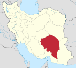
Narmashir (Persian: نرماشير, romanized: Narmāshīr)[a] is a city in the Central District of Narmashir County, Kerman province, Iran, serving as capital of both the county and the district.[5]
History
[edit]In the middle ages, Narmashir was one of the major cities of Kerman, but it was not at its present location — the ruins at the nearby village of Choghukabad are the most likely candidate for the site of medieval Narmashir.[6] The medieval geographers al-Muqaddasi, Yaqut al-Hamawi, and Hamdallah Mustawfi described medieval Narmashir as a large and prosperous town on the main trade route connecting Kerman with Sistan.[6] Merchants travelling between Oman and Khorasan did business here, and there was also a market for Indian goods.[6] The town was walled, with four gates and a citadel, and there was a congregational mosque built of fired brick.[6] Narmashir was one of the five kuras (districts) of Kerman during this period.[6] Sometime between Mustawfi's account in the 14th century, Narmashir became abandoned; European travellers in the 19th century found no trace of it.[6]
Demographics
[edit]Population
[edit]At the time of the 2006 National Census, the city's population was 3,966 in 1,007 households,[7] when it was capital of the former Narmashir District of Bam County[8] The following census in 2011 counted 6,167 people in 1,587 households,[9] by which time the district had been separated from the county in the establishment of Narmashir County. Narmashir was transferred to the new Central District as the county's capital.[5] The 2016 census measured the population of the city as 5,222 people in 1,545 households.[2]
See also
[edit]Notes
[edit]References
[edit]- ^ OpenStreetMap contributors (7 December 2024). "Narmashir, Narmashir County" (Map). OpenStreetMap (in Persian). Retrieved 7 December 2024.
- ^ a b Census of the Islamic Republic of Iran, 1395 (2016): Kerman Province. amar.org.ir (Report) (in Persian). The Statistical Center of Iran. Archived from the original (Excel) on 20 October 2020. Retrieved 19 December 2022.
- ^ Habibi, Hassan (c. 2024) [Approved 28 February 1377]. Transforming the village of Rostamabad, the center of Narmashir District, Bam County, Kerman province, into the city of Narmashir. lamtakam.com (Report) (in Persian). Ministry of the Interior, Council of Ministers. Proposal 1.4.42.10691; Notification 16996T/18938H. Archived from the original on 4 December 2024. Retrieved 4 December 2024 – via Lam ta Kam.
- ^ Narmashir can be found at GEOnet Names Server, at this link, by opening the Advanced Search box, entering "-3081351" in the "Unique Feature Id" form, and clicking on "Search Database".
- ^ a b Rahimi, Mohammad Reza (c. 2023) [Approved 23 March 1389]. Letter of approval regarding national divisions in Kerman province. qavanin.ir (Report) (in Persian). Ministry of the Interior, Council of Ministers. Proposal 42/4/1/44515. Archived from the original on 5 July 2023. Retrieved 5 July 2023 – via Laws and Regulations Portal of the Islamic Republic of Iran.
- ^ a b c d e f Bosworth, C.E. (1993). "NARMĀSHĪR". In Bosworth, C.E.; van Donzel, E.; Heinrichs, W.P.; Pellat, Ch. (eds.). The Encyclopaedia of Islam, Vol. VII (MIF-NAZ). Leiden: Brill. p. 965. ISBN 90-04-09419-9. Retrieved 21 December 2022.
- ^ Census of the Islamic Republic of Iran, 1385 (2006): Kerman Province. amar.org.ir (Report) (in Persian). The Statistical Center of Iran. Archived from the original (Excel) on 20 September 2011. Retrieved 25 September 2022.
- ^ Habibi, Hassan (c. 2023) [Approved 16 November 1370]. Approval of reforms in the villages of Kerman province. qavanin.ir (Report) (in Persian). Ministry of the Interior, Defense Political Commission of the Government Council. Resolution 5/11/1370. Archived from the original on 29 June 2023. Retrieved 29 June 2023 – via Laws and Regulations Portal of the Islamic Republic of Iran.
- ^ Census of the Islamic Republic of Iran, 1390 (2011): Kerman Province. irandataportal.syr.edu (Report) (in Persian). The Statistical Center of Iran. Archived from the original (Excel) on 29 March 2023. Retrieved 19 December 2022 – via Iran Data Portal, Syracuse University.


 French
 Deutsch
