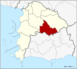
Nong Yai district
Nong Yai หนองใหญ่ | |
|---|---|
 District location in Chonburi province | |
| Coordinates: 13°9′24″N 101°22′0″E / 13.15667°N 101.36667°E | |
| Country | Thailand |
| Province | Chonburi |
| Seat | Nong Yai |
| Tambon | 5 |
| Area | |
| • Total | 397.5 km2 (153.5 sq mi) |
| Population (2015) | |
| • Total | 23,609 |
| • Density | 59.39/km2 (153.8/sq mi) |
| Time zone | UTC+7 (ICT) |
| Postal code | 20190 |
| Geocode | 2003 |
Nong Yai (Thai: หนองใหญ่, pronounced [nɔ̌ːŋ jàj]) is a district (amphoe) in the province Chonburi, Thailand.
History
[edit]The minor district (king amphoe) Nong Yai was created on 1 December 1975. The three tambons, Nong Yai, Khlong Phlu, and Nong Suea Chang were split off from Ban Bueng district.[1] It was upgraded to a full district on 13 July 1981.[2]
Geography
[edit]Neighboring districts are (from the south clockwise) Wang Chan and Pluak Daeng of Rayong province, Si Racha, Ban Bueng and Bo Thong of Chonburi Province.
Administration
[edit]The district is divided into five sub-districts (tambons), which are further subdivided into 24 villages (mubans). Nong Yai is a township (thesaban tambon) which covers the whole tambon Nong Yai. There are a further four tambon administrative organizations (TAO).
| No. | Name | Thai name | Villages | Pop. | |
|---|---|---|---|---|---|
| 1. | Nong Yai | หนองใหญ่ | 6 | 7,530 | |
| 2. | Khlong Phlu | คลองพลู | 4 | 3,645 | |
| 3. | Nong Suea Chang | หนองเสือช้าง | 5 | 4,106 | |
| 4. | Hang Sung | ห้างสูง | 5 | 3,333 | |
| 5. | Khao Sok | เขาซก | 4 | 3,370 |
References
[edit]- ^ ประกาศกระทรวงมหาดไทย เรื่อง แบ่งท้องที่อำเภอบ้านบึง จังหวัดชลบุรี ตั้งเป็นกิ่งอำเภอหนองใหญ่ (PDF). Royal Gazette (in Thai). 92 (245 ง): 3062. December 1, 1975. Archived from the original (PDF) on September 30, 2007.
- ^ พระราชกฤษฎีกาตั้งอำเภอหนองใหญ่ อำเภอบ่อไร่ อำเภอพรหมคีรี อำเภอนาบอน อำเภอบางสะพานน้อย อำเภอนาดี อำเภอกงหรา อำเภอวังทรายพูน อำเภอธารโต อำเภอคำตากล้า อำเภอศรีนคร อำเภอด่านช้าง อำเภอพรเจริญ อำเภอวังสามหมอ และอำเภอลานสัก พ.ศ. ๒๕๒๔ (PDF). Royal Gazette (in Thai). 98 (115 ก Special): 7–10. July 13, 1981. Archived from the original (PDF) on September 30, 2007.


 French
 Deutsch