
 French
 Deutsch
Okhaldhunga
This article needs additional citations for verification. (October 2018) |
Okhaldhunga ओखलढुङ्गा | |
|---|---|
Merged to Siddhicharan Municipality | |
 Okhaldhunga Location in Nepal | |
| Coordinates: 27°19′N 86°30′E / 27.317°N 86.500°E | |
| Country | |
| Zone | Sagarmatha Zone |
| District | Okhaldhunga District |
| Elevation | 1,561 m (5,121 ft) |
| Population (1991) | |
| • Total | 3,761 |
| Time zone | UTC+5:45 (Nepal Time) |
Okhaldhunga is the headquarters of the Okhaldhunga District in the Sagarmatha Zone of Nepal. At the time of the 1991 Nepal census it had a population of 3761 living in 790 individual households.[1]
Climate
[edit]| Climate data for Okhaldhunga, elevation 1,731 m (5,679 ft), (1991–2020) | |||||||||||||
|---|---|---|---|---|---|---|---|---|---|---|---|---|---|
| Month | Jan | Feb | Mar | Apr | May | Jun | Jul | Aug | Sep | Oct | Nov | Dec | Year |
| Mean daily maximum °C (°F) | 15.8 (60.4) | 18.1 (64.6) | 21.8 (71.2) | 24.6 (76.3) | 25.2 (77.4) | 25.4 (77.7) | 24.9 (76.8) | 25.1 (77.2) | 24.6 (76.3) | 23.6 (74.5) | 20.8 (69.4) | 17.4 (63.3) | 22.3 (72.1) |
| Daily mean °C (°F) | 10.6 (51.1) | 12.6 (54.7) | 16.2 (61.2) | 19.1 (66.4) | 20.3 (68.5) | 21.3 (70.3) | 21.3 (70.3) | 21.4 (70.5) | 20.6 (69.1) | 18.7 (65.7) | 15.4 (59.7) | 12.1 (53.8) | 17.5 (63.5) |
| Mean daily minimum °C (°F) | 5.3 (41.5) | 7.1 (44.8) | 10.5 (50.9) | 13.6 (56.5) | 15.3 (59.5) | 17.2 (63.0) | 17.7 (63.9) | 17.6 (63.7) | 16.6 (61.9) | 13.7 (56.7) | 10.0 (50.0) | 6.7 (44.1) | 12.6 (54.7) |
| Average precipitation mm (inches) | 12.0 (0.47) | 14.9 (0.59) | 25.8 (1.02) | 66.5 (2.62) | 153.0 (6.02) | 292.9 (11.53) | 417.8 (16.45) | 416.0 (16.38) | 265.0 (10.43) | 61.2 (2.41) | 8.0 (0.31) | 8.2 (0.32) | 1,741.3 (68.56) |
| Average precipitation days (≥ 1.0 mm) | 1.6 | 2.2 | 3.9 | 7.9 | 14.0 | 18.4 | 22.2 | 21.4 | 16.3 | 5.4 | 1.0 | 0.8 | 115.1 |
| Source 1: World Meteorological Organization[2] | |||||||||||||
| Source 2: Department of Hydrology and Meteorology[3] | |||||||||||||
Media
[edit]To promote local culture Okhaldhunga has two FM radio stations: Radio Likhu (91.3 MHz) and Ramailo Samudayek Radio (100.6 MHz), both of which are community radio stations.[4][5][6]
Gallery
[edit]-
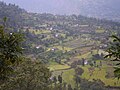
 tholedema khijeeview
 -
 toledema
 -
 Gaungtol
 -
 dandakhi
 -
 KhijiV
 -
 KhijiDVC2
 -
 Khijee3
 -
 Khiji4
 -
 satatol
 -
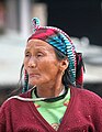 Portrait of a woman at Okhaldunga
 -
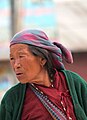 Portrait of a woman at Okhaldunga


References
[edit]- ^ "Nepal Census 2001", Nepal's Village Development Committees, Digital Himalaya, archived from the original on October 12, 2008, retrieved 15 November 2009.
- ^ "World Meteorological Organization Climate Normals for 1991–2020". World Meteorological Organization. Retrieved 14 October 2023.
- ^ "PRECIPITATION NORMAL (MM) (1991-2020)" (PDF). Department of Hydrology and Meteorology. Archived from the original (PDF) on 14 October 2023. Retrieved 14 October 2023.
- ^ "ASSOCIATION OF COMMUNITY RADIO BROADCASTERS NEPAL (ACORAB)::Introduction". www.acorab.org.np. Retrieved 2020-06-30.
- ^ Network, Indigenous Community Radio. "Radio Likhu 91.3 MHz". Indigenous Community Radio Network. Retrieved 2020-06-30.
- ^ Report on BHN visit to Radio Kairan and Radio Likhu in Ramechhap, archived from the original on 2021-12-21, retrieved 2020-06-30
External links
[edit]Headquarters: Okhaldhunga | ||
| Urban municipality |  | |
| Rural municipalities | ||
| International | |
|---|---|
| National | |