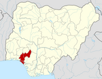
Ose, Nigeria
Ose, Nigeria | |
|---|---|
 | |
| Country | |
| State | Ondo State |
| Area | |
• Total | 566 sq mi (1,465 km2) |
| Population (2006) | |
• Total | 144,901 |
| Time zone | UTC+1 (WAT) |
 | |
Ose is a Local Government Area in Ondo State, Southwest Nigeria. Its headquarters is in the town of Ifon. It is made up communities including Ikaro, Okeluse, Ijagba, Imoru, Arimogija, Elegbeka (Ikaro), Ogberuwen, Ute, Ifon, Omi-alafa, Ugbonla, and Ogbese Falodun to the south; and Ido-ani, Idogun, Ido-isale, Afo, and Imeri to the north.
The major activity of this region is farming, mostly based around cocoa and plantation farming.
The traditional ruler of Ifon, Oba Israel Adegoke Adewusi, was murdered on 26 November 2020.[1]
It has an area of 1,465 km2 and a population of 144,901 as of the 2006 census.
References
[edit]- ^ Bankole, Idowu (28 June 2021). "Leaders, youths lament high profile killing in Ondo community". Vanguard News. Retrieved 28 November 2024.


 French
 Deutsch