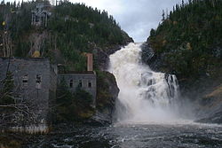
Ouiatchouan River
| Ouiatchouan River | |
|---|---|
 | |
 | |
| Location | |
| Country | Canada |
| Province | Quebec |
| Region | Saguenay–Lac-Saint-Jean |
| MRC | Le Domaine-du-Roy Regional County Municipality |
| Physical characteristics | |
| Source | Lac des Commissaires |
| • location | Lac-Bouchette |
| • coordinates | 48°12′12″N 72°14′32″W / 48.20333°N 72.24222°W |
| • elevation | 331 m (1,086 ft) |
| Mouth | Lac Saint-Jean |
• location | Chambord |
• coordinates | 48°26′53″N 72°09′33″W / 48.44806°N 72.15917°W |
• elevation | 101 m (331 ft) |
| Length | 35 km (22 mi) |
| Basin features | |
| Progression | Lac Saint-Jean, Saguenay River |
| Tributaries | |
| • left | (upstream) Ouellet River, 3 lakes outlet, 5 lakes outlet, Petite rivière Ballantyne, Sergerie River, Noire River. |
| • right | (upstream) ruisseau non-identifié, Petite rivière de la Savane, décharge du Lac des Bouleaux, Le Faux Canal. |
La rivière Ouiatchouan (formerly Ouiatchouane[1]) is a tributary of lac Saint-Jean, flowing in the municipalities of Lac-Bouchette and Chambord, in the Le Domaine-du-Roy Regional County Municipality, in the administrative region of Saguenay–Lac-Saint-Jean, from province of Quebec, to Canada.
Apart from the lower zone, forestry is the main economic activity in this valley.[2]
The surface of the Ouiatchouan River is usually frozen from the beginning of December to the end of March, except the rapids areas; however, safe circulation on the ice is generally from mid-December to mid-March.
Geography
[edit]Flowing towards North, this river of about 25 km (16 mi) has its source in the Ouiatchouan Lake, the Bouchette Lake and Lac des Commissaires. The Ouiatchouan River receives its water directly from the Lac des Commissaires, which flows into the Bouchette Lake. This last lake flows through a small channel in Ouiatchouan Lake.
The mouth of Ouiatchouan Lake flows north-west to the bottom of a bay (0.7 km (0.43 mi) deep) in the Ouiatchouan River, in range VI, of Canton Dublon, from Lac-Bouchette; then this river crosses range IV flowing north. Then, the river crosses ranges III, II and I of the Canton of Dablon of the municipality of Saint-François-de-Sales; in range I, it receives water from Martin stream on the west side.
The river continues its course to the north in the Canton of Charlevoix where it receives on the east side the waters of the Petite Rivière de la Savane. The latter flows in ranges II and I of the Dablon township; its mouth crosses the Ouiatchane river in range VII of the township of Charlevoix. A little further, the Ouiatchane river receives on the west side the waters of the Little Ballantyne river at range VI, where the river branches off to the East. The waters then cross several rapids of row VI: rapids of the islet, rapids Ballantyne and rapids of the Devil. In Chambord, the river crosses ranges V, IV, III, II and I; the waters then cross several obstacles: pine rapid (range IV), Grands Rapides (range II) and the Ouiatchouan waterfall (range II at Val Jalbert). At the end of its course, the river generates majestic falls in the heritage village of Val Jalbert, then the waters flow into a cove south of lac Saint-Jean.[3]
The Ouiatchouan River flows for 28 km (17 mi) north to reach Lac Saint-Jean, 6.5 km (4.0 mi) northwest of the intersection of route 155 and route 169. The Ouiatchouan river flows mainly in wooded areas, except the last two kilometers of its route which are agricultural in nature.[4]
Harnessing project
[edit]In the early 2010s, the Ouiatchouan River was the subject of a harnessing project). This hydroelectric development project is provoking a debate between promoters of the work and supporters of the "protection" of the river.[5][6][7]
Toponymy
[edit]The toponym "rivière Ouiatchouan" was formalized on December 5, 1968, at the Bank of Place Names of the Commission de toponymie du Québec, that is to say at the creation of this commission.[8]
See also
[edit]Notes and references
[edit]- ^ Commission de toponymie du Québec, /fiche.aspx?no_seq=148370 Ouiatchouan River [online] (Page consulted on January 9, 2013)
- ^ OpenStreetMap – Accessed July 13, 2020
- ^ Maps dated October 22, 1990, of Mapping service of the Ministry of Energy and Resources, Government of Quebec.
- ^ Geographical checks carried out on May 25, 2014, by the historian Gaétan Veillette (Saint-Hubert, QC) with reference to the maps published on the Google Map website.
- ^ Alexandre Shields (December 7, 2012). "A power station would not threaten the heritage value of Val-Jalbert". Le Devoir. Montreal. Retrieved January 9, 2013.
- ^ CNW TELBEC,Hydroelectric development project of the Ouiatchouan River at the Village historique de Val-Jalbert – The BAPE report is now public [online] (Page consulted on January 9, 2013)
- ^ "Hydroelectric development project of the Ouiatchouan river in the Historic Village of Val-Jalbert" (PDF). Fondation Rivières. 2012. Retrieved April 13, 2012.
- ^ Commission de toponymie du Québec – Bank of Place Names – Toponym: Rivière Ouiatchouan
External links
[edit]- Bureau of public hearings on the environment, ed. (June 28, 2012). Hydroelectric development project of the Ouiatchouan river in the historic village of Val-Jalbert – collection=289 – Report of investigation and public hearings (PDF). Quebec: BAPE. p. 90. ISBN 978-2-550-65126-0. BAPE2012.
- Québec, ed. (1997). Commission of inquiry on the policy of Hydro-Québec purchasing electricity from private producers (Doyon Commission) - Report final (in French). Quebec, Ministère du Conseil exécutif. p. 607. ISBN 2-551-17686-7. Doyon1997.
- Bureau of public hearings on the environment, ed. (August 30, 1994). Val-Jalbert hydroelectric development project - Investigation report and of public hearings - collection=82 (PDF) (in French). Quebec: BAPE. p. 135. ISBN 2-550-29799-7. BAPE1994.


 French
 Deutsch