Pence (CDP), Wisconsin
Pence, Wisconsin | |
|---|---|
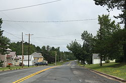
 Looking east in downtown Pence | |
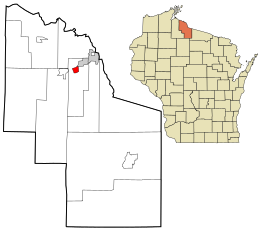
 Location in Iron County and the state of Wisconsin. | |
| Coordinates: 46°24′55″N 90°16′18″W / 46.41528°N 90.27167°W | |
| Country | United States |
| State | Wisconsin |
| County | Iron |
| Town | Pence |
| Area | |
• Total | 1.068 sq mi (2.77 km2) |
| • Land | 1.068 sq mi (2.77 km2) |
| • Water | 0 sq mi (0 km2) |
| Elevation | 1,631 ft (497 m) |
| Population (2010) | |
• Total | 131 |
| • Density | 120/sq mi (47/km2) |
| Time zone | UTC-6 (Central (CST)) |
| • Summer (DST) | UTC-5 (CDT) |
| Area code(s) | 715 & 534 |
| GNIS feature ID | 1571168[1] |


Pence is an unincorporated census-designated place in Pence, Iron County, Wisconsin, United States. Pence is located on Wisconsin Highway 77, 1.5 miles (2.4 km) southwest of Montreal. As of the 2010 census, its population is 131.[2]
References
[edit]Wikimedia Commons has media related to Pence, Wisconsin.
- ^ U.S. Geological Survey Geographic Names Information System: Pence (CDP), Wisconsin
- ^ "U.S. Census website". U.S. Census Bureau. Retrieved April 17, 2011.


 French
 Deutsch