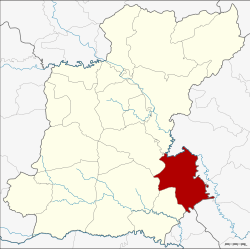
Phanom Phrai district
Phanom Phrai พนมไพร | |
|---|---|
 District location in Roi Et province | |
| Coordinates: 15°40′42″N 104°6′36″E / 15.67833°N 104.11000°E | |
| Country | Thailand |
| Province | Roi Et |
| Area | |
| • Total | 519.3 km2 (200.5 sq mi) |
| Population (2005) | |
| • Total | 75,140 |
| • Density | 144.7/km2 (375/sq mi) |
| Time zone | UTC+7 (ICT) |
| Postal code | 45140 |
| Geocode | 4506 |
Phanom Phrai (Thai: พนมไพร, pronounced [pʰā.nōm pʰrāj]; Northeastern Thai: พนมไพร, pronounced [pʰā.no᷇m pʰa᷇j]) is a district (amphoe) in the southeastern part of Roi Et province, northeastern Thailand.
Geography
[edit]Neighboring districts are (from the southwest clockwise): Nong Hi, Suwannaphum, At Samat, Selaphum of Roi Et Province; Mueang Yasothon, Kham Khuean Kaeo, Maha Chana Chai of Yasothon province; and Sila Lat of Sisaket province.
Administration
[edit]The district is divided into 13 sub-districts (tambons), which are further subdivided into 160 villages (mubans). Phanom Phrai is a township (thesaban tambon) which covers parts of tambon Phanom Phrai. There are a further 13 tambon administrative organizations (TAO).
| No. | Name | Thai name | Villages | Pop. | |
|---|---|---|---|---|---|
| 1. | Phanom Phrai | พนมไพร | 19 | 11,295 | |
| 2. | Saen Suk | แสนสุข | 18 | 8,714 | |
| 3. | Kut Nam Sai | กุดน้ำใส | 10 | 3,859 | |
| 4. | Nong Thap Thai | หนองทัพไทย | 14 | 7,284 | |
| 5. | Pho Yai | โพธิ์ใหญ่ | 14 | 7,046 | |
| 6. | Wari Sawat | วารีสวัสดิ์ | 11 | 4,516 | |
| 7. | Khok Sawang | โคกสว่าง | 16 | 5,030 | |
| 11. | Pho Chai | โพธิ์ชัย | 12 | 7,195 | |
| 12. | Na Nuan | นานวล | 13 | 4,759 | |
| 13. | Kham Hai | คำไฮ | 10 | 5,574 | |
| 14. | Sa Kaeo | สระแก้ว | 9 | 3,677 | |
| 15. | Kho Yai | ค้อใหญ่ | 7 | 2,288 | |
| 17. | Chanuwan | ชานุวรรณ | 7 | 3,903 |
Missing numbers are tambons which now form Nong Hi District.


 French
 Deutsch