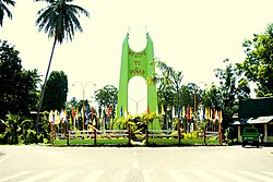
Piñan
This article needs additional citations for verification. (January 2023) |
Piñan | |
|---|---|
| Municipality of Piñan | |
 Welcome Rotonda | |
Nickname:
| |
 Map of Zamboanga del Norte with Piñan highlighted | |
Location within the Philippines | |
| Coordinates: 8°28′56″N 123°27′00″E / 8.4822°N 123.45°E | |
| Country | Philippines |
| Region | Zamboanga Peninsula |
| Province | Zamboanga del Norte |
| District | 1st district |
| Founded | August 22, 1951 |
| Barangays | 22 (see Barangays) |
| Government | |
| • Type | Sangguniang Bayan |
| • Mayor | Cecilia J. Carreon |
| • Vice Mayor | Rommel I. Gudmalin |
| • Representative | Roberto T. Uy Jr. |
| • Municipal Council | Members |
| • Electorate | 16,271 voters (2022) |
| Area | |
• Total | 93.75 km2 (36.20 sq mi) |
| Elevation | 68 m (223 ft) |
| Highest elevation | 274 m (899 ft) |
| Lowest elevation | 12 m (39 ft) |
| Population (2020 census)[3] | |
• Total | 20,221 |
| • Density | 220/km2 (560/sq mi) |
| • Households | 4,965 |
| Economy | |
| • Income class | 4th municipal income class |
| • Poverty incidence | 43.27 |
| • Revenue | ₱ 150.7 million (2022) |
| • Assets | ₱ 334.6 million (2022) |
| • Expenditure | ₱ 122.4 million (2022) |
| • Liabilities | ₱ 334.6 million (2022) |
| Service provider | |
| • Electricity | Zamboanga del Norte Electric Cooperative (ZANECO) |
| Time zone | UTC+8 (PST) |
| ZIP code | 7105 |
| PSGC | |
| IDD : area code | +63 (0)65 |
| Native languages | Subanon Cebuano Chavacano Tagalog |
| Website | www |
Piñan, officially the Municipality of Piñan (Cebuano: Lungsod sa Piñan; Subanen: Benwa Piñan; Chavacano: Municipalidad de Piñan; Tagalog: Bayan ng Piñan), is a municipality in the province of Zamboanga del Norte, Philippines. According to the 2020 census, it has a population of 20,221 people.[3]
It is also known as New Piñan.[5]
Etymology
[edit]Piñan came from a Subano term pinyayan which means tabuan (trading place). Before it was established as a formal settlement, this place has been a trading point between natives to the area and ambulant peddlers. In 1903, Captain Finley, a military governor in Zamboanga, established a tabuan in what is now known as Barangay Del Pilar. The tabuan became known as Piñan, and when the municipality was created it was called New Piñan to differentiate it from Piñan.
Another version states that Piñan got its name from the native word piña, a pineapple fruit that grows abundantly in this locality. Vast tracts of pineapple plantations can be seen all over the area. Because of abundance of piña fruits, natives called the place Piñan.
History
[edit]The inhabitants of Piñan were engaged in farming. They cultivated their field by using the “kaingin” system, in which the land was cleared by setting fire to woody plant and bushes, after which holes were bored in the ground with pointed sticks and seeds were planted. They also used wooden plows and harrows drawn by carabaos. Then, Piñan became the source of farm production using their famous horse- or cattle-driven caretelas, and people from neighboring municipalities began coming to Piñan to purchase agricultural products and establish tabuan.[citation needed]
By virtue of Executive Order No. 467 signed by President Elpidio Quirino on August 22, 1951, the municipality of New Piñan, along with Polanco, was organized, separated from Dipolog in the old undivided Zamboanga province. The municipality contains sixteen sitios, organized into barrios, with one with the same name the seat of the government.[6] It was inaugurated through the effort of Serapio J. Datoc, the then-Governor of Zamboanga, and declared as an independent municipality.[7]
The name of the municipality was renamed Piñan through Republic Act No. 2846, enacted on June 19, 1960.[8]
In 1963, the barrios of Dampalan, Labag, Princess La Maya, Marapong, and Sibulan were separated from Piñan to form the new independent municipality of Sergio Osmeña.[9]
Geography
[edit]Barangays
[edit]Piñan is politically subdivided into 22 barangays. Each barangay consists of puroks while some have sitios.
- Adante
- Bacuyong
- Bagong Silang
- Calican
- Del Pilar
- Desin
- Dilawa
- Dionum
- Lapu-lapu
- Lower Gumay
- Luzvilla
- Poblacion North
- Poblacion South
- Santa Fe
- Segabe
- Sikitan
- Silano
- Teresita
- Tinaytayan
- Ubay (Daan Tipan)
- Upper Gumay
- Villarico
Climate
[edit]| Climate data for Piñan, Zamboanga del Norte | |||||||||||||
|---|---|---|---|---|---|---|---|---|---|---|---|---|---|
| Month | Jan | Feb | Mar | Apr | May | Jun | Jul | Aug | Sep | Oct | Nov | Dec | Year |
| Mean daily maximum °C (°F) | 28 (82) | 29 (84) | 30 (86) | 31 (88) | 30 (86) | 29 (84) | 29 (84) | 29 (84) | 30 (86) | 29 (84) | 29 (84) | 29 (84) | 29 (85) |
| Mean daily minimum °C (°F) | 23 (73) | 23 (73) | 23 (73) | 23 (73) | 24 (75) | 24 (75) | 24 (75) | 24 (75) | 24 (75) | 24 (75) | 24 (75) | 23 (73) | 24 (74) |
| Average precipitation mm (inches) | 104 (4.1) | 76 (3.0) | 92 (3.6) | 97 (3.8) | 199 (7.8) | 238 (9.4) | 195 (7.7) | 193 (7.6) | 178 (7.0) | 212 (8.3) | 171 (6.7) | 110 (4.3) | 1,865 (73.3) |
| Average rainy days | 14.7 | 12.5 | 15.8 | 17.5 | 27.6 | 28.5 | 29.0 | 27.5 | 26.9 | 27.9 | 23.5 | 18.2 | 269.6 |
| Source: Meteoblue[10] | |||||||||||||
Demographics
[edit]| Year | Pop. | ±% p.a. |
|---|---|---|
| 1960 | 24,699 | — |
| 1970 | 12,335 | −6.70% |
| 1975 | 13,121 | +1.25% |
| 1980 | 14,373 | +1.84% |
| 1990 | 15,419 | +0.71% |
| 1995 | 19,447 | +4.44% |
| 2000 | 17,950 | −1.70% |
| 2007 | 18,669 | +0.54% |
| 2010 | 20,088 | +2.70% |
| 2015 | 20,161 | +0.07% |
| 2020 | 20,221 | +0.06% |
| Source: Philippine Statistics Authority[11][12][13][14] | ||
Economy
[edit]Poverty incidence of Piñan
10 20 30 40 50 60 2000 48.40 2003 47.34 2006 45.80 2009 55.52 2012 40.20 2015 46.05 2018 46.49 2021 43.27 Source: Philippine Statistics Authority[15][16][17][18][19][20][21][22] |
References
[edit]- ^ Municipality of Piñan | (DILG)
- ^ "2015 Census of Population, Report No. 3 – Population, Land Area, and Population Density" (PDF). Philippine Statistics Authority. Quezon City, Philippines. August 2016. ISSN 0117-1453. Archived (PDF) from the original on May 25, 2021. Retrieved July 16, 2021.
- ^ a b Census of Population (2020). "Region IX (Zamboanga Peninsula)". Total Population by Province, City, Municipality and Barangay. Philippine Statistics Authority. Retrieved 8 July 2021.
- ^ "PSA Releases the 2021 City and Municipal Level Poverty Estimates". Philippine Statistics Authority. 2 April 2024. Retrieved 28 April 2024.
- ^ "Zamboanga del Norte : Municipality of Pinan". Old website of Zamboanga del Norte. Archived from the original on 17 November 2002. Retrieved 15 October 2020.
- ^ Executive Order No. 467, s. 1951 (August 22, 1951), Organizing the Municipalities of Polanco and New Piñan in the Province of Zamboanga, Official Gazette of the Republic of the Philippines, retrieved March 20, 2023
- ^ "About Piñan". 2012.
- ^ Republic Act No. 2846 (June 19, 1960), An Act Changing the Name of the Municipality of New Piñan, Province of Zamboanga Del Norte, to Piñan, Supreme Court E-Library, retrieved March 20, 2023
- ^ Republic Act No. 3697 (June 22, 1963), An Act Creating the Municipality of Sergio Osmeña in the Province of Zamboanga Del Norte, The Lawphil Project - Arellano Law Foundation, Inc., retrieved December 9, 2023
- ^ "Piñan: Average Temperatures and Rainfall". Meteoblue. Retrieved 30 April 2020.
- ^ Census of Population (2015). "Region IX (Zamboanga Peninsula)". Total Population by Province, City, Municipality and Barangay. Philippine Statistics Authority. Retrieved 20 June 2016.
- ^ Census of Population and Housing (2010). "Region IX (Zamboanga Peninsula)" (PDF). Total Population by Province, City, Municipality and Barangay. National Statistics Office. Retrieved 29 June 2016.
- ^ Censuses of Population (1903–2007). "Region IX (Zamboanga Peninsula)". Table 1. Population Enumerated in Various Censuses by Province/Highly Urbanized City: 1903 to 2007. National Statistics Office.
- ^ "Province of". Municipality Population Data. Local Water Utilities Administration Research Division. Retrieved 17 December 2016.
- ^ "Poverty incidence (PI):". Philippine Statistics Authority. Retrieved December 28, 2020.
- ^ "Estimation of Local Poverty in the Philippines" (PDF). Philippine Statistics Authority. 29 November 2005.
- ^ "2003 City and Municipal Level Poverty Estimates" (PDF). Philippine Statistics Authority. 23 March 2009.
- ^ "City and Municipal Level Poverty Estimates; 2006 and 2009" (PDF). Philippine Statistics Authority. 3 August 2012.
- ^ "2012 Municipal and City Level Poverty Estimates" (PDF). Philippine Statistics Authority. 31 May 2016.
- ^ "Municipal and City Level Small Area Poverty Estimates; 2009, 2012 and 2015". Philippine Statistics Authority. 10 July 2019.
- ^ "PSA Releases the 2018 Municipal and City Level Poverty Estimates". Philippine Statistics Authority. 15 December 2021. Retrieved 22 January 2022.
- ^ "PSA Releases the 2021 City and Municipal Level Poverty Estimates". Philippine Statistics Authority. 2 April 2024. Retrieved 28 April 2024.
External links
[edit]


 French
 Deutsch

