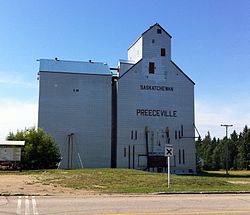
Preeceville
Preeceville | |
|---|---|
 The grain elevator in Preeceville | |
Preeceville in Saskatchewan | |
| Coordinates: 51°57′29″N 102°40′02″W / 51.9580222°N 102.6673164°W[1] | |
| Country | Canada |
| Province | Saskatchewan |
| Census division | 9 |
| Rural Municipality | Preeceville |
| Post office Founded | 1912-03-01 |
| Incorporated (Village) | 1912 |
| Incorporated (Town) | 1947 |
| Government | |
| • Mayor | Ralph Ager |
| • Administrator | Lorelei Karcha |
| • Governing body | Preeceville Town Council |
| Area | |
• Town | 3.06 km2 (1.18 sq mi) |
| Elevation | 500 m (1,700 ft) |
| Population (2016) | |
| • Urban | 1,125 |
| • Urban density | 368.2/km2 (954/sq mi) |
| Time zone | UTC-6 (CST) |
| • Summer (DST) | UTC-6 (CST) |
| Postal code | S0A 3B0 |
| Area code(s) | 306/639 |
| Highways | |
| Waterways | Assiniboine River |
| Website | Official Website |
| [3][4] | |
Preeceville is a town in Saskatchewan, Canada. The town is 10 kilometres (6.2 mi) west of Sturgis and 99 kilometres (62 mi) north of Yorkton at the junction of Highway 49, Highway 47, Highway 9 and near Highway 755.
History
[edit]Settlement in the Preeceville region dates back to fur traders who came to the upper Assiniboine region after explorer David Thompson mapped the area in 1796. Later, ranchers followed the trails left by fur traders and Indigenous peoples, leading to the earliest settlement of the area.
Preeceville was officially established as a village in 1912, the same year the Canadian National Railway arrived, further driving settlement in the region.[5]
The town is named for the Preece family, who set up a homestead where the town now stands in 1905.[6]
Demographics
[edit]In the 2021 Census of Population conducted by Statistics Canada, Preeceville had a population of 1,062 living in 492 of its 570 total private dwellings, a change of -5.6% from its 2016 population of 1,125. With a land area of 2.86 square kilometres (1.10 sq mi), it had a population density of 371.3/km2 (961.7/sq mi) in 2021.[7]
| 2021 | 2011 | |
|---|---|---|
| Population | 1,062 (-5.6% from 2016) | 1,070 (1.9% from 2006) |
| Land area | 2.86 km2 (1.10 sq mi) | 3.06 km2 (1.18 sq mi) |
| Population density | 371.8/km2 (963/sq mi) | 350.2/km2 (907/sq mi) |
| Median age | 51.6 (M: 48.4, F: 54.4) | 53.4 (M: 49.4, F: 57.8) |
| Private dwellings | 495 (total) | 579 (total) |
| Median household income |
Transportation
[edit]The community is served by Preeceville Airport, which is located 1 nautical mile (1.9 km) southeast.
See also
[edit]References
[edit]- ^ "The Atlas of Canada Toporama". Retrieved 20 August 2014.
- ^ "Preeceville - NRC". Natural Resources Canada. Retrieved 20 August 2014.
- ^ National Archives, Archivia Net, Post Offices and Postmasters, retrieved 1 December 2013
- ^ Government of Saskatchewan, MRD Home. "Municipal Directory System". Retrieved 1 December 2013.
- ^ "History". Town of Preeceville. Retrieved 11 September 2024.
- ^ Preeceville Historical Society, Corporate; et al. (Courtesy of Local Histories Collection, Libraries and Cultural Resources Digital Collections, University of Calgary) (1 January 1982). Lines of the Past.
- ^ "Population and dwelling counts: Canada, provinces and territories, census divisions and census subdivisions (municipalities), Saskatchewan". Statistics Canada. 9 February 2022. Retrieved 1 April 2022.
- ^ "2021 Community Profiles". 2021 Canadian census. Statistics Canada. 4 February 2022. Retrieved 27 April 2022.
- ^ "2011 Community Profiles". 2011 Canadian census. Statistics Canada. 21 March 2019. Retrieved 15 August 2014.


 French
 Deutsch


