RAF Gambut
| RAF Gambut | |
|---|---|
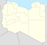
| Near: Kambut, Libya | |
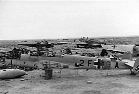
 Abandoned German aircraft at Gambut after its recapture by the Allies (December 1941) | |
| Coordinates | 31°57′04″N 024°30′14″E / 31.95111°N 24.50389°E |
| Site information | |
| Operator | |
| Controlled by | Regia Aeronautica (1939-1942) German Luftwaffe (1941–1942) Royal Air Force (1942–1944) Ninth Air Force (1942–43) |
| Site history | |
| In use | 1941–1944 |
| Battles/wars | World War II |
RAF Gambut (or RAF Kambut) is a complex of six abandoned military airfields in Libya, located about 5 kilometres (3 mi) north-northeast of the village of Kambut, and 50 kilometres (31 mi) east-south-east of Tobruk. During World War II, the complex was an important facility, used by the Royal Air Force and many RAF squadrons were temporarily based there.
History
[edit]Gambiut was an airfield of Regia Aeronautica. Axis forces re-captured Gambut on 17 June 1941, after the Battle of Tobruk.[1] This was a significant blow to the Allies as the airfield had been used to provide air-support to the Allied forces in the Siege of Tobruk. The airfield saw use by the Luftwaffe until its recapture by the New Zealand 4th Infantry Brigade on 25 November.[2]
Today the remains of the airfields – deteriorating under the desert sands – are visible on aerial photographs.
Airfields at Gambut
[edit]This station consisted of six airfields known as Gambut 1 (LG139), this being the main airfield, Gambut 2 (LG142), Gambut 3 (LG143), Gambut West/Gambut 4 (LG156), Gambut 5 (LG159) and Gambut 6 (LG158). [1]

| RAF Designation | No. Designation | Location |
|---|---|---|
| Gambut Main (No.1) | LG-139 | 31°52′5″N 24°29′5″E / 31.86806°N 24.48472°E |
| Gambut No. 2 | LG-142 | 31°51′5″N 24°32′5″E / 31.85139°N 24.53472°E |
| Gambut No. 3 | LG-143 | 31°50′5″N 24°36′5″E / 31.83472°N 24.60139°E |
| Gambut Comms No. 4 | LG-156 | 31°54′0″N 24°25′5″E / 31.90000°N 24.41806°E |
| Gambut No. 5 | LG-159 | 31°52′0″N 24°25′5″E / 31.86667°N 24.41806°E |
| Gambut No. 6 | LG-158 | 31°50′0″N 24°39′0″E / 31.83333°N 24.65000°E |
Major units assigned
[edit]Gambut Main (No.1)
- Units
- Squadrons
- 6, 11, 14, 33, 38, 45, 46, 47 55, 73, 80, 84 108, 112, 113, 145, 148, 162, 203, 208, 227, 229, 237, 238, 250, 252, 274, 294, 450 (RAAF), 454 (RAAF)
- HQ, 239 Wing (1 Mar – 17 Jun 1942, 14–15 Nov 1942)
- HQ, 243 Wing (May – 20 Jun 1942)
- HQ, 233 Wing (14–18 Nov 1942)
- HO, 223 Wing (SAAF)
Gambut (No.2)
- Units
- Squadrons
- 73, 112, 250, 274, 450 (RAAF)
- HQ, 233 Wing (22 May – 28 Jun 1942)
Gambut (No.3)
- Units
- Squadrons
- 14, 73, 117, 250, 294, 454 (RAAF), 459 (RAAF), 603
- HQ, 235 Wing (3 Dec 1942 – 29 Feb 1944)
Gambut West
- Units
- Squadrons
- 73, 92, 145, 208, 213, 238, 601
- HQ, 285 Wing (14–20 Nov 1942)
- United States Army Air Forces[4]
- 12th Bombardment Group (B-25 Mitchell)
- 434th Bombardment Squadron 17 December 1942 – 16 February 1943
- 93d Bombardment Group 16–25 February 1943 (B-24 Liberator)
- 409th Bombardment Squadron 16 Dec 1942 – 25 February 1943
- 376th Bombardment Group 10–25 February 1943 (B-24 Liberator)
- 57th Fighter Group 13–20 November 1942 (P-40 Warhawk)
See also
[edit]References
[edit]- Citations
- ^ Mitcham, Samuel W. (2007). Rommel's Desert War: The Life and Death of the Afrika Korps. Stackpole Books. p. 81. ISBN 978-0811734134.
- ^ Mitcham, Samuel W. (2007). Rommel's Desert Commanders: The Men Who Served the Desert Fox, North Africa, 1941–1942. Greenwood Publishing Group. p. 101. ISBN 978-0275994365.
- ^ "RAF Gambut". Air of Authority – A History of RAF Organisation. Retrieved 30 March 2015.
- ^ Maurer, Maurer, ed. (1983) [1961]. Air Force Combat Units of World War II (PDF) (repr. ed.). Washington, DC: Office of Air Force History. pp. 160–162. ISBN 0-912799-02-1. LCCN 61060979.
- Bibliography
- Maurer, Maurer, ed. (1983) [1961]. Air Force Combat Units of World War II (PDF) (repr. ed.). Washington, DC: Office of Air Force History. ISBN 0-912799-02-1. LCCN 61060979.
- Maurer, Maurer, ed. (1982) [1969]. Combat Squadrons of the Air Force, World War II (PDF) (repr. ed.). Washington, DC: Office of Air Force History. ISBN 0-405-12194-6. LCCN 70605402. OCLC 72556.
![]() This article incorporates public domain material from the Air Force Historical Research Agency
This article incorporates public domain material from the Air Force Historical Research Agency
External links
[edit]


 French
 Deutsch
