Ratměřice
Ratměřice | |
|---|---|
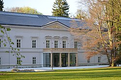
 Ratměřice Castle | |
| Coordinates: 49°38′36″N 14°45′22″E / 49.64333°N 14.75611°E | |
| Country | |
| Region | Central Bohemian |
| District | Benešov |
| First mentioned | 1220 |
| Area | |
• Total | 9.54 km2 (3.68 sq mi) |
| Elevation | 498 m (1,634 ft) |
| Population (2024-01-01)[1] | |
• Total | 313 |
| • Density | 33/km2 (85/sq mi) |
| Time zone | UTC+1 (CET) |
| • Summer (DST) | UTC+2 (CEST) |
| Postal code | 257 03 |
| Website | www |
Ratměřice is a municipality and village in Benešov District in the Central Bohemian Region of the Czech Republic. It has about 300 inhabitants.
Administrative division
[edit]Ratměřice consists of three municipal parts (in brackets population according to the 2021 census):[2]
- Ratměřice (212)
- Hrzín (17)
- Skrýšov (32)
Geography
[edit]Ratměřice is located about 16 kilometres (10 mi) south of Benešov and 46 km (29 mi) southeast of Prague. It lies in the Vlašim Uplands. The highest point is at 575 m (1,886 ft) above sea level.
History
[edit]The first written mention of Ratměřice is from 1220. Hrzín and Skrýšov were first mentioned in 1318. In the 14th century, Ratměřice became property of the monastery in Louňovice pod Blaníkem. After the monastery was burned down in 1420 as a result of the Hussite Wars, Ratměřice was acquired by the town of Tábor. Tábor owned it until 1547, when properties of the town were confiscated. Ratměřice was subsequently purchased by Oldřich Skuhrovský of Skuhrov.[3]
From 1622 to 1702, Ratměřice was property of the Talmberk family. In 1645, during the Battle of Jankau of the Thirty Years' War, the village was completely burned down, but was restored when the war ended. The Kořenský of Terešov family held the village from 1702 to 1719. They had built here a castle. Other notable owners of Ratměřice were the families of Sternthal (1751–1830) and Chotek (1830–1898).[3]
Demographics
[edit]
|
|
| ||||||||||||||||||||||||||||||||||||||||||||||||||||||
| Source: Censuses[4][5] | ||||||||||||||||||||||||||||||||||||||||||||||||||||||||
Transport
[edit]There are no railways or major roads passing through the municipality.
Sights
[edit]The main landmark is the Church of Saint Gall. Built in the Romanesque style, it was probably founded in the first third of the 13th century. It was modified in the Gothic style. In the 19th century, further modifications were made.[6]
The Ratměřice Castle is a Baroque building from the early 18th century. In the late 19th century, it was rebuilt into its present Neo-Renaissance form. Today the castle is privately owned and serves as a hotel and a restaurant. The castle is surrounded by a park with rare trees. The largest two giant sequoias in the Czech Republic are located here.[3][7]
References
[edit]- ^ "Population of Municipalities – 1 January 2024". Czech Statistical Office. 2024-05-17.
- ^ "Public Census 2021 – basic data". Public Database (in Czech). Czech Statistical Office. 2022.
- ^ a b c "Historie obce" (in Czech). Obec Ratměřice. Retrieved 2023-04-14.
- ^ "Historický lexikon obcí České republiky 1869–2011" (in Czech). Czech Statistical Office. 2015-12-21.
- ^ "Population Census 2021: Population by sex". Public Database. Czech Statistical Office. 2021-03-27.
- ^ "Kostel sv. Havla" (in Czech). National Heritage Institute. Retrieved 2023-04-14.
- ^ "Zámek" (in Czech). National Heritage Institute. Retrieved 2023-04-14.


 French
 Deutsch

