Samarqand Region
Samarqand Region Самарқанд вилояти / Samarqand viloyati Самаркандская область | |
|---|---|
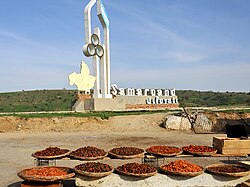
 'Welcome to Samarqand' | |
 Samarqand in Uzbekistan | |
| Coordinates: 39°50′N 66°15′E / 39.833°N 66.250°E | |
| Country | Uzbekistan |
| Established | 1938 |
| Capital | Samarqand |
| Government | |
| • Hokim | Erkinjon Turdimov |
| Area | |
| • Total | 16,773 km2 (6,476 sq mi) |
| Elevation | 577 m (1,893 ft) |
| Population (2022) | |
| • Total | 4,031,324 |
| • Density | 240/km2 (620/sq mi) |
| Time zone | UTC+5 (East) |
| • Summer (DST) | UTC+5 (not observed) |
| ISO 3166 code | UZ-SA |
| Districts | 14 |
| Cities | 11 |
| Website | www |
Samarqand Region[a][b] is the most populous region of Uzbekistan.[1] It is located in the center of the country in the basin of the Zarafshan River. It borders Tajikistan, Navoiy Region, Jizzakh Region and Qashqadaryo Region. It covers an area of 16,773 km2. The population is estimated to be around 4,031,324, with some 63% living in rural areas (as of 2022).[1]
Samarqand Region was established on 15 January 1938,[2] and is divided into 14 administrative districts and two district-level cities.[3] The capital is Samarqand (pop. ~551,700 as of 2021).[4][5] Other major towns include Bulungʻur, Juma, Ishtixon, Kattakurgan, Urgut, and Oqtosh.
The climate is a typically arid continental climate.
Samarqand is the second-largest center for economy, science, and culture in Uzbekistan, after Tashkent. The region's UNESCO World Heritage Site architectural monuments make Samarqand the largest center for international tourism in the country. Samarqand Region also has significant natural resources, including construction materials such as marble, granite, limestone, carbonate, and chalk. The region's major agricultural activities are cotton and cereal growing, winemaking and sericulture. Metal processing (spare parts for automobiles and combines), food processing, textiles, and ceramics are the area's most active industries.
The region has a well-developed transport infrastructure, with over 400 km of railways and 4,100 km of surfaced roads. The telecommunication infrastructure is also well developed.
Administrative divisions
[edit]

The Samarqand Region consists of 14 districts (listed below) and two district-level cities: Samarqand (Samarqand) and Kattakurgan (Kattaqoʻrgʻon).[3][4]
| District name | District capital | |
|---|---|---|
| 1 | Bulungʻur District | Bulungʻur |
| 2 | Ishtixon District | Ishtixon |
| 3 | Jomboy District | Jomboy |
| 4 | Kattakurgan District | Payshanba |
| 5 | Qoʻshrabot District | Qoʻshrabot |
| 6 | Narpay District | Oqtosh |
| 7 | Nurobod District | Nurobod |
| 8 | Oqdaryo District | Loyish |
| 9 | Paxtachi District | Ziyovuddin |
| 10 | Payariq District | Payariq |
| 11 | Pastdargʻom District | Juma |
| 12 | Samarqand District | Gulobod |
| 13 | Toyloq District | Toyloq |
| 14 | Urgut District | Urgut |
There are 11 cities (Samarqand, Kattakurgan, Bulungʻur, Jomboy, Ishtixon, Oqtosh, Payariq, Chelak, Juma, Nurobod, Urgut) and 88 urban-type settlements in the Samarqand Region.[3][4]
See also
[edit]Notes
[edit]References
[edit]- ^ a b "O'zbekistonda eng ko'p aholi qaysi viloyatda yashaydi?". Qalampir.uz (in Uzbek). Retrieved 2022-02-10.
- ^ Information about the Samarqand Region Archived 2007-10-08 at the Wayback Machine, www.samarqand.uz, accessed on 2007-07-21.
- ^ a b c "Oʻzbekiston Respublikasining maʼmuriy-hududiy boʻlinishi" [Administrative-territorial division of the Republic of Uzbekistan] (in Uzbek). The State Committee of the Republic of Uzbekistan on statistics. July 2021. Archived from the original on 4 February 2022.
- ^ a b c "Classification system of territorial units of the Republic of Uzbekistan" (in Uzbek and Russian). The State Committee of the Republic of Uzbekistan on statistics. July 2020.
- ^ "Urban and rural population by district" (PDF) (in Uzbek). Samarkand regional department of statistics.


 French
 Deutsch