Sedgwick, Arkansas
Sedgwick, Arkansas | |
|---|---|
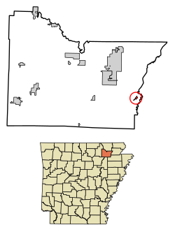
 Location in Lawrence County, Arkansas | |
| Coordinates: 35°58′44″N 90°51′46″W / 35.97889°N 90.86278°W | |
| Country | United States |
| State | Arkansas |
| County | Lawrence |
| Area | |
• Total | 0.52 sq mi (1.35 km2) |
| • Land | 0.52 sq mi (1.35 km2) |
| • Water | 0.00 sq mi (0.00 km2) |
| Elevation | 262 ft (80 m) |
| Population (2020) | |
• Total | 163 |
| • Density | 314.07/sq mi (121.16/km2) |
| Time zone | UTC-6 (Central (CST)) |
| • Summer (DST) | UTC-5 (CDT) |
| ZIP code | 72465 |
| Area code | 870 |
| FIPS code | 05-63110 |
| GNIS feature ID | 0058595[2] |
Sedgwick is a town in Lawrence County, Arkansas, United States. The population was 152 at the 2010 census,[3] up from 112 at the 2000 census.
History
[edit]About 1881 George Washington Sedgwick, president of the Sedgwick Tie Company, "established a sawmill on the Cache River in Lawrence County, Arkansas, and a small town was established named Sedgwick, Ark."[4]
Geography
[edit]Sedgwick is in eastern Lawrence County, less than 1 mile (1.6 km) west of the Cache River, which forms the Lawrence County/Greene County line.
U.S. Route 63 passes through the town, leading northwest 10 miles (16 km) to Hoxie and southeast 14 miles (23 km) to Jonesboro. Arkansas Highway 228 leads northeast from Sedgwick 9 miles (14 km) to U.S. Route 412 at Light.
Demographics
[edit]| Census | Pop. | Note | %± |
|---|---|---|---|
| 1900 | 309 | — | |
| 1910 | 96 | −68.9% | |
| 1920 | 195 | 103.1% | |
| 1930 | 137 | −29.7% | |
| 1940 | 352 | 156.9% | |
| 1950 | 196 | −44.3% | |
| 1960 | 206 | 5.1% | |
| 1970 | 168 | −18.4% | |
| 1980 | 205 | 22.0% | |
| 1990 | 86 | −58.0% | |
| 2000 | 112 | 30.2% | |
| 2010 | 152 | 35.7% | |
| 2020 | 163 | 7.2% | |
| U.S. Decennial Census[5] | |||
As of the census[6] of 2000, there were 112 people, 44 households, and 31 families residing in the town. The population density was 818.5 inhabitants per square mile (316.0/km2). There were 51 housing units at an average density of 372.7 per square mile (143.9/km2). The racial makeup of the town was 98.21% White, 0.89% Black or African American and 0.89% Native American.
There were 44 households, out of which 27.3% had children under the age of 18 living with them, 61.4% were married couples living together, 6.8% had a female householder with no husband present, and 27.3% were non-families. 25.0% of all households were made up of individuals, and 13.6% had someone living alone who was 65 years of age or older. The average household size was 2.55 and the average family size was 3.03.
In the town, the population was spread out, with 23.2% under the age of 18, 12.5% from 18 to 24, 29.5% from 25 to 44, 17.0% from 45 to 64, and 17.9% who were 65 years of age or older. The median age was 35 years. For every 100 females, there were 124.0 males. For every 100 females age 18 and over, there were 104.8 males.
The median income for a household in the town was $20,417, and the median income for a family was $25,417. Males had a median income of $25,000 versus $18,750 for females. The per capita income for the town was $11,988. There were no families and 4.0% of the population living below the poverty line, including no under eighteens and 22.2% of those over 64.
References
[edit]- ^ "2020 U.S. Gazetteer Files". United States Census Bureau. Retrieved October 29, 2021.
- ^ a b U.S. Geological Survey Geographic Names Information System: Sedgwick, Arkansas
- ^ "Geographic Identifiers: 2010 Census Summary File 1 (G001), Sedgwick town, Arkansas". American FactFinder. U.S. Census Bureau. Archived from the original on February 13, 2020. Retrieved August 23, 2019.
- ^ Sedgwick, Hubert Merrill (1961). A Sedgwick Genealogy: Descendants of Deacon Benjamin Sedgwick. New Haven Colony Historical Society. p. 154. Retrieved August 23, 2019.
{{cite book}}:|website=ignored (help) - ^ "Census of Population and Housing". Census.gov. Retrieved June 4, 2015.
- ^ "U.S. Census website". United States Census Bureau. Retrieved January 31, 2008.


 French
 Deutsch