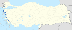
State road D.550 (Turkey)
| D.550 | |
|---|---|
 | |
| Route information | |
| Part of | |
| Length | 774 km (481 mi) |
| Major junctions | |
| North end | Edirne |
| South end | Muğla |
| Location | |
| Country | Turkey |
| Highway system | |
D.550 is a north-to-south state road in Turkey. It runs mostly along the west coast of Turkey. It starts at Edirne and ends in Muğla. The first 226 kilometres (140 mi) of the road are in the European part of Turkey. Between Eceabat and Çanakkale, it passes over the Strait of Çanakkale (popularly known as Dardanelles) by ferryboat. The rest of the road is in the Asiatic (so called Anatolia) portion of Turkey. Being north to east road it crosses the major west to east roads in Turkey like D.200 in Çanakkale and D.400 in İzmir. It shares the same itinerary with D.100 between Edirne and Havsa at the north and it shares the same itinerary with D.400 between Yatağan and Muğla at the south.
Itinerary
[edit]| Province | Location | Distance from Edirne (km)[1] | Distance from Edirne (mile) | Distance from Muğla (km) | Distance from Muğla (mile) |
|---|---|---|---|---|---|
| Edirne | |||||
| Edirne | 0 | 0 | 774 | 481 | |
| Havsa | 27 | 17 | 747 | 464 | |
| Uzunköprü | 111 | 69 | 663 | 412 | |
| Keşan[2] | 153 | 95 | 621 | 386 | |
| Çanakkale | |||||
| Gelibolu | 181 | 112 | 593 | 368 | |
| Eceabat | 226 | 140 | 548 | 341 | |
| Çanakkale[3] | 227 | 141 | 547 | 340 | |
| Ezine[2] | 276 | 170 | 500 | 311 | |
| Ayvacık[2] | 298 | 185 | 476 | 296 | |
| Balıkesir | |||||
| Edremit | 360 | 224 | 414 | 257 | |
| Burhaniye | 372 | 231 | 402 | 250 | |
| Ayvalık[2] | 401 | 249 | 373 | 232 | |
| İzmir | |||||
| Dikili junction | 437 | 272 | 337 | 209 | |
| Aliağa | 494 | 307 | 280 | 174 | |
| Menemen[2] | 522 | 325 | 252 | 157 | |
| İzmir | 549 | 341 | 225 | 140 | |
| Torbalı | 598 | 371 | 176 | 109 | |
| Selçuk | 629 | 391 | 145 | 90 | |
| Aydın | |||||
| Germencik | 653 | 406 | 121 | 75 | |
| Aydın | 675 | 419 | 99 | 62 | |
| Çine | 711 | 442 | 63 | 39 | |
| Muğla | |||||
| Yatağan junction | 748 | 465 | 26 | 16 | |
| Muğla | 774 | 481 | 0 | 0 |


 French
 Deutsch
