Terter Peak


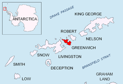
Terter Peak (Bulgarian: връх Тертер, romanized: vrah Terter, IPA: [ˈvrɤx ˈtɛrtɛr]) is an ice-covered peak rising to 570 m in Breznik Heights, Greenwich Island in the South Shetland Islands, Antarctica surmounting Wulfila Glacier to the southwest, Solis Glacier to the northwest and Zheravna Glacier to the southeast.
Location
[edit]The peak is located at 62°32′18″S 59°43′03″W / 62.53833°S 59.71750°W, which is 740 m northwest of Razgrad Peak, 1.77 km east-southeast of the summit of Oborishte Ridge, 3.61 km south of Correa Point, 1.77 km west-southwest of Momchil Peak and 2.07 km north of the coastal point formed by Ephraim Bluff (Bulgarian topographic survey Tangra 2004/05).
The peak is named after Czar Svetoslav Terter of Bulgaria, 1300-1321 AD.
Maps
[edit]- L.L. Ivanov et al. Antarctica: Livingston Island and Greenwich Island, South Shetland Islands. Scale 1:100000 topographic map. Sofia: Antarctic Place-names Commission of Bulgaria, 2005.
- L.L. Ivanov. Antarctica: Livingston Island and Greenwich, Robert, Snow and Smith Islands. Scale 1:120000 topographic map. Troyan: Manfred Wörner Foundation, 2009. ISBN 978-954-92032-6-4
References
[edit]- Terter Peak. SCAR Composite Gazetteer of Antarctica
- Bulgarian Antarctic Gazetteer. Antarctic Place-names Commission. (details in Bulgarian, basic data in English)
External links
[edit]- Terter Peak. Copernix satellite image
This article includes information from the Antarctic Place-names Commission of Bulgaria which is used with permission.


 French
 Deutsch