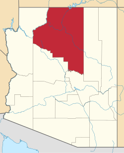
Timberline-Fernwood, Arizona
Timberline-Fernwood, Arizona | |
|---|---|
| Coordinates: 35°19′00″N 111°33′03″W / 35.31667°N 111.55083°W | |
| Country | United States |
| State | Arizona |
| County | Coconino |
| Area | |
• Total | 9.83 sq mi (25.47 km2) |
| • Land | 9.83 sq mi (25.47 km2) |
| • Water | 0.00 sq mi (0.00 km2) |
| Elevation | 6,706 ft (2,044 m) |
| Population (2020) | |
• Total | 2,572 |
| • Density | 261.59/sq mi (101.00/km2) |
| Time zone | UTC-7 (MST) |
| • Summer (DST) | UTC-6 (MDT) |
| ZIP Code | 86004 (Flagstaff) |
| FIPS code | 04-73890 |
| GNIS feature ID | 2805231[2] |
Timberline-Fernwood is a census-designated place (CDP) in Coconino County, Arizona, United States. It is bordered to the south by the community of Doney Park and is on U.S. Route 89, 11 miles (18 km) northeast of Flagstaff. It was first listed as a CDP prior to the 2020 census.
Demographics
[edit]| Census | Pop. | Note | %± |
|---|---|---|---|
| 2020 | 2,572 | — | |
| U.S. Decennial Census[3] | |||
Education
[edit]Timberline-Fernwood is within the Flagstaff Unified School District.[4] The zoned secondary schools are Sinagua Middle School and Coconino High School.[5]
References
[edit]- ^ "2020 U.S. Gazetteer Files". United States Census Bureau. Retrieved October 29, 2021.
- ^ a b U.S. Geological Survey Geographic Names Information System: Timberline-Fernwood, Arizona
- ^ "Census of Population and Housing". Census.gov. Retrieved June 4, 2016.
- ^ "2020 census - school district reference map: Coconino County, AZ" (PDF). United States Census Bureau. p. 4 (PDF pp. 5/5). Archived (PDF) from the original on October 9, 2022. Retrieved September 12, 2024. - Text list
- ^ "2010/2011 Middle (6–8) and High (9–12) School Attendance Areas" (PDF). Flagstaff Unified School District. Retrieved September 12, 2024. – Compare to the US Census Bureau maps.


 French
 Deutsch

