Tokyo Bay Aqua-Line
| Tokyo Wan Aqua-Line Expressway | |
|---|---|
The Tokyo Bay Aqua-Line highlighted in red | |
| Route information | |
| Length | 23.7 km (14.7 mi) |
| Existed | 1997–present |
| Component highways | |
| Major junctions | |
| West end | Kawasaki Ukishima Junction in Kawasaki, Kanagawa |
| Section 1 | |
| East end | Kisarazu Interchange Kisarazu, Chiba |
| Location | |
| Country | Japan |
| Highway system | |
Tokyo Bay Aqua-Line 東京湾アクアライン | |
|---|---|
 Tokyo Bay Aqua-Line (bridge section) | |
| Coordinates | 35°27′47″N 139°52′31″E / 35.46306°N 139.87528°E |
| Carries | 4 lanes of |
| Crosses | Tokyo Bay |
| Locale | |
| Other name(s) | Trans-Tokyo Bay Highway |
| Characteristics | |
| Design |
|
| Total length |
|
| Width | 22.9 metres (75 ft)[2] |
| Longest span | 240 metres (787 ft)[3] |
| Piers in water | 42[2] |
| Clearance below | 29 metres (95 ft)[2] |
| History | |
| Fabrication by | |
| Construction start | 1989 |
| Construction cost | ¥1.4 trillion |
| Opened | 18 December 1997[6] |
| Location | |
 | |
 Umihotaru, where bridge transitions to tunnel | |
| Overview | |
|---|---|
| Status |
|
| Start | Umihotaru Island |
| End | Ukishima, Kawasaki, Kanagawa |
| Operation | |
| Constructed | Taisei[7] |
| Technical | |
| No. of lanes | 2 (unidirectional) in each of 2 tunnels |
| Highest elevation | sea level |
| Lowest elevation | −45 metres (−148 ft) |
| Width |
|
| Grade | 4%[8] |
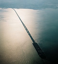
The Tokyo Bay Aqua-Line (東京湾アクアライン, Tōkyō-wan Akua-rain[9]), also known as the Trans-Tokyo Bay Expressway, is an expressway that is mainly made up of a bridge–tunnel combination across Tokyo Bay in Japan. It connects the city of Kawasaki in Kanagawa Prefecture with the city of Kisarazu in Chiba Prefecture, and forms part of National Route 409. With an overall length of 23.7 km, it includes a 4.4 km bridge and 9.6 km tunnel underneath the bay—the fourth-longest underwater tunnel in the world.[10]
Overview
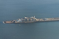
[edit]An artificial island, Umihotaru (海ほたる, Umi-hotaru, "sea firefly," referring to Vargula hilgendorfii), marks the transition between the bridge and tunnel segments and provides a rest stop with restaurants, shops, and amusement facilities. A distinctive tower standing above the middle of the tunnel, the Kaze no Tō (風の塔, "the tower of wind"), supplies air to the tunnel, its ventilation system powered by the bay's almost-constant winds.


The Tokyo Bay Aqua-Line shortened the drive between Chiba and Kanagawa, two important industrial areas, from 90 to 15 minutes,[11] and also helped cut travel time from Tokyo and Kanagawa to the seaside leisure spots of the southern Bōsō Peninsula. Before it opened, the trip entailed a 100 km journey along Tokyo Bay and pass through central Tokyo.

An explicit goal of the Aqua-Line was to redirect vehicular flow away from central Tokyo, but the expensive toll has meant only a limited reduction in central-Tokyo traffic.
Many highway bus services now use the Tokyo Bay Aqua-Line, including lines from Tokyo Station, Yokohama Station, Kawasaki Station, Shinagawa Station, Shibuya Station, Shinjuku Station and Haneda Airport to Kisarazu, Kimitsu, Nagaura station, Ichihara, Mobara, Tōgane, Kamogawa, Katsuura and Tateyama.
History
[edit]One of the last Japanese megaprojects of the 20th century,[12] the roadway was built at a cost of the ¥1.44 trillion (US$11.2 billion) and opened on December 18, 1997[6] by then-Crown Prince Naruhito and then-Crown Princess Masako[13] after 23 years of planning and nine years of construction. The roadway was conceived during the bubble economy of the late 1980s.[13]
At opening time, the roadway had the highest toll fee in Japan – a one-way trip costs ¥5050 or ¥334 per kilometer.[12] Due to its expensive toll, analysts see lower traffic volume than what Japan Highway Public Corporation, the operator of the roadway, expected at 25,000 cars.[13]
Tolls
[edit]The cash toll for a single trip on the Aqua-Line is ¥3,140 for ordinary-size cars (¥2,510 for kei cars); however, using the ETC (electronic toll collection) system, the fare is ¥2320 (¥1860 for kei cars). The ETC toll is reduced to ¥1000 on Saturdays, Sundays and holidays. In general, tolls for usage of the Aqua-Line in either direction are collected at the mainline toll plaza on the Kisarazu end.
| Type of car | Toll | ETC Aqua-Line Special discount | ETC Pilot Test discount (from July 2009) |
|---|---|---|---|
| Normal cars | 3,140JPY | 2,320JPY | 800JPY |
| Midsize cars | 3,770JPY | 2,780JPY | 960JPY |
| Large cars | 5,190JPY | 3,830JPY | 1,320JPY |
| Specific large cars | 8,640JPY | 6,380JPY | 2,200JPY |
| Kei-cars and motorcycles | 2,510JPY | 1,860JPY | 640JPY |
See also
[edit]- List of bridge–tunnels
- Chesapeake Bay Bridge–Tunnel
- Busan–Geoje Fixed Link
- Hong Kong–Zhuhai–Macau Bridge
- Bataan–Cavite Interlink Bridge
References
[edit]- ^ "Developments of transportation and industries, do bring a more comfortable life to every body". Tokyo wan Aqua-line. 1998. Archived from the original on 3 December 1998. Retrieved 6 March 2015.
- ^ a b c d Shioi, Y.; Nakamura, S. (1994). "8: Design Concept of the Trans-Tokyo Bay Bridge". In Pritchard, B.P. (ed.). Continuous and Integral Bridges. London: E & FN Spon. pp. 75–84. ISBN 0-419-19030-9. Retrieved 8 March 2015.
- ^ Nagai, Masatsugu; Okui, Yoshiaki; Kawai, Yutaka; Yamamoto, Masaaki; Saito, Kimio (2014). "23: Bridge Engineering in Japan". In Chen, Wai-Fah; Duan, Lian (eds.). Handbook of International Bridge Engineering. Boca Raton: CRC Press. p. 1048. ISBN 978-1-4398-1030-9. Retrieved 6 March 2015.
- ^ "Steel Bridges: Structures in Japan". Yokogawa Bridge Corporation. Archived from the original on 7 January 2015. Retrieved 6 March 2015.
- ^ "Girder bridges". JFE Engineering Corporation. Retrieved 6 March 2015.
- ^ a b "Japan opens world's longest undersea tunnel". The Straits Times. Reuters. 19 December 1997.
- ^ "Taisei Corporation's Journey over 140 Years" (PDF). Taisei Corporation. 2014. Archived from the original (PDF) on 2 April 2015. Retrieved 8 March 2015.
- ^ Funasaki, Tsuneyoshi; Yamada, Norio; Izumi, Yasutaka; Miki, Keizou (1998). "Construction of Trans-Tokyo Bay Highway". IABSE Reports. 78: 43–48. doi:10.5169/seals-59019.
- ^ Katakana-shingo-jiten, Gakken 2003, ISBN 4-05-301351-8
- ^ Hotta, Kenji (2002). "4: Tokyo Bay Reformation". In Chen, Jiyu; Eisma, Doeke; Hotta, Kenji; Walker, H. Jesse (eds.). Engineered Coasts. Dordrecht: Kluwer Academic. pp. 94–95. ISBN 1-4020-0521-0. Retrieved 6 March 2015.
- ^ "JAPAN Big New Crossings Can Use Much More Traffic | TOLLROADSnews". Archived from the original on 2010-02-11. Retrieved 2009-11-02.
- ^ a b "World's longest undersea tunnel: Tokyo's costly folly?". The Straits Times. AFP. 15 December 1997.
- ^ a b c "World's longest submarine road opens". Business Times (Singapore). AFP. 19 December 1997.
External links
[edit]- Japan Highways site (in Japanese)
- (in Japanese) East Nippon Expressway Company
- NEXCO East's info regarding U-turns at Umi-hotaru (in Japanese)
- Trans-Tokyo Bay Highway at Structurae. Retrieved 6 March 2015.
- Tokyo Bay Aqualine at Structurae. Retrieved 6 March 2015.
- Tokyo Bay Aqualine Bridge at Structurae. Retrieved 6 March 2015.
- Tokyo Bay Aqualine Tunnel at Structurae. Retrieved 6 March 2015.
- Alfred, Randy (18 December 2008). "Dec. 18, 1997: 360 Seconds Under Tokyo". WIRED. Retrieved 6 March 2015.
- "The World's Largest-Scale Marine Civil Engineering Project: The Trans-Tokyo Bay Highway" (PDF). KAJIMA News & Notes. 3: 2–5. Autumn 1997. Retrieved 6 March 2015.
- Uchida, K; Shioi, Y; Hirukawa, T; Tatsuoka, F (8–12 August 1993). Wu, JTH; Barrett, R.K. (eds.). The Trans-Tokyo Bay Highway project - a huge project currently under construction. Transportation Facilities Through Difficult Terrain. Aspen-Snowmass, Colorado. pp. 57–87. ISBN 90-5410-343-4.
- Tatsuoka, F. (1998). "Geotechnical Engineering Aspects of Trans-Tokyo Bay Highway Project" (PDF). Saitama University. Retrieved 8 March 2015.
- "Trans-Tokyo Bay Highway" (PDF). Trans-Tokyo Bay Highway Corporation. c. 1990. Archived from the original (PDF) on 2 April 2015. Retrieved 8 March 2015.


 French
 Deutsch
