Topoľovka
Topoľovka | |
|---|---|
Municipality | |
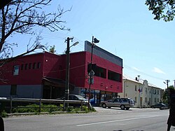
 Main street in Topoľovka, the centre of village. Buildings on the left are the commune council building with civil registry and rural market | |
Location of Topoľovka in the Prešov Region | |
| Coordinates: 48°55′10″N 21°48′30″E / 48.91944°N 21.80833°E | |
| Country | |
| Region | Prešov |
| District | Humenné |
| First mentioned | 1479 |
| Area | |
• Total | 7.787 km2 (3.007 sq mi) |
| Elevation | 157 m (515 ft) |
| Population (31 December 2005) | |
• Total | 824 |
| • Density | 110/km2 (270/sq mi) |
| Time zone | UTC+1 (CET) |
| • Summer (DST) | UTC+2 (CEST) |
| Postal code | 067 45 |
| Area code | +421-57 |
| Car plate | HE |
| Website | topolovka |
Topoľovka is a village and municipality in Humenné District in the Prešov Region of north-east Slovakia.
History
[edit]In historical records the village was first mentioned in 1479.
Geography
[edit]The municipality lies at an altitude of 157 metres (515 feet) and covers an area of 7.777 square kilometres (3.003 square miles). It has a population of about 825 people.
International relations
[edit]Twin towns — Sister cities
[edit]Topoľovka is twinned with:
External links
[edit] Media related to Topoľovka at Wikimedia Commons
- Official website

- http://www.statistics.sk/mosmis/eng/run.html


 French
 Deutsch
