
 French
 Deutsch
Ubalá
Ubalá | |
|---|---|
Municipality and town | |
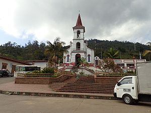
 Church of Ubalá | |
 Flag  Seal | |
 Location of the municipality and town inside Cundinamarca Department of Colombia | |
 Ubalá Location in Colombia | |
| Coordinates: 4°44′38″N 73°32′5″W / 4.74389°N 73.53472°W | |
| Country | |
| Department | |
| Province | Guavio Province |
| Founded | 23 October 1846 |
| Founded by | Ospina Rodríguez |
| Government | |
| • Mayor | Danilo Antonio Salinas Martínez (2016-2019) |
| Area | |
| • Municipality and town | 505 km2 (195 sq mi) |
| Elevation | 1,949 m (6,394 ft) |
| Population (2015) | |
| • Municipality and town | 10,718 |
| • Density | 21/km2 (55/sq mi) |
| • Urban | 1,280 |
| Time zone | UTC-5 (Colombia Standard Time) |
| Website | Official website |
Ubalá is a municipality and town of Colombia in the department of Cundinamarca. It is located in the Eastern Ranges of the Colombian Andes. It is the only municipality of Cundinamarca that is split in two parts.
Climate
[edit]| Ubalá - 1949 m | ||||||||||||||||||||||||||||||||||||||||||||||||||||||||||||
|---|---|---|---|---|---|---|---|---|---|---|---|---|---|---|---|---|---|---|---|---|---|---|---|---|---|---|---|---|---|---|---|---|---|---|---|---|---|---|---|---|---|---|---|---|---|---|---|---|---|---|---|---|---|---|---|---|---|---|---|---|
| Climate chart (explanation) | ||||||||||||||||||||||||||||||||||||||||||||||||||||||||||||
| ||||||||||||||||||||||||||||||||||||||||||||||||||||||||||||
| ||||||||||||||||||||||||||||||||||||||||||||||||||||||||||||
Etymology
[edit]In the Chibcha language of the Muisca, Ubalá means "Place on the hillside" or "At the foot of the hillside".[1]
History
[edit]The region west to Ubalá was inhabited by the Muisca before the Spanish conquistadores entered the Altiplano Cundiboyacense. To the east of Ubalá the indigenous Tegua were living and to the south the Guayupe.
Ubalá was properly founded on October 23, 1846 by Ospina Rodríguez.
Administrative Division
[edit]The municipality of Ubalá is the only one in the department that is geographically divided into two zones and each has municipal inspections and these in turn in villages:
Ubalá A (western) It is characterized by being very mountainous and being on the northern shore of the Guavio Reservoir and has the following inspections:
1) Central: made up of the following villages: El Carmelo, Las Mercedes, Sagrado Corazón (which is the municipal urban area), San Antonio de Ubalá, San Isidro, San José, San Juan, San Luis, San Pablo, San Pedro, San Roque Oeste and Santa María.
2) Santa Rosa: created by agreement number 12 of September 12, 1907 and made up of the villages: Cascajal, El Carmen, San Antonio Rosa, Santa Rosa and Santa Rosita.
3) Laguna Azul: Villages: Betania, El Cartucho, El Eden, Laguna Azul, Rionegro, Robledal, Sanctuary and Sion
4) La Playa: Villages: La Playa, Mundo Nuevo, San Cayetano and Santa Teresa Oeste
5) Peñas Blancas: Villages: Cascades, La Mesa, Margaritas, Peñas Blancas and San Fernando
Ubalá B (eastern) Its main mountain range is the Medina cliffs, which separate the Guavio region from the Llanos de la Orinoquía. It is made up of the jurisdiction of three inspections:
1) Mambita: Villages: Algodones, Boca de Monte, Campo Hermoso, La Floresta, Mambita and San Roque Este
2)Soy: Villages: Gibraltar, La Romaza, San Luis Bajo and Soya
3) San Pedro de Jagua: Villages: Alto de San Luis, El Carmen, Gazajujo, Puerto Rico, San Pedro de Jagua and Santa Teresa.
Economy
[edit]Main economical activity of Ubalá is mining, predominantly emeralds, iron ore, sandstones, clay and salt.
Gallery
[edit]-
 Church view
 -
 Church close-up
 -
 Mining iron ore
 -
 Laguna Verde
 -
 Rural part of Ubalá


-
 Guavio artificial lake
 -
 Guavio river
 -
 Guavio lake
 -
 Edge of Guavio lake
.JPG)


References
[edit]- ^ (in Spanish) Etymology Ubalá
| Gold |  | |
|---|---|---|
| Silver | ||
| Platinum | ||
| Nickel | ||
| Coltan | ||
| Emeralds | ||
| Coal | ||
| Salt | ||
| Sources | ||
| Geology |  | ||||
|---|---|---|---|---|---|
| History |
| ||||
| Main mining areas |
| ||||
| Individual mines |
| ||||
| Individual emeralds (ct) |
| ||||
| Related articles | |||||