Veleň
Veleň | |
|---|---|
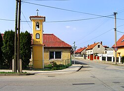
 Belfry in the centre of Veleň | |
| Coordinates: 50°10′24″N 14°33′15″E / 50.17333°N 14.55417°E | |
| Country | |
| Region | Central Bohemian |
| District | Prague-East |
| First mentioned | 1318 |
| Area | |
• Total | 6.87 km2 (2.65 sq mi) |
| Elevation | 211 m (692 ft) |
| Population (2024-01-01)[1] | |
• Total | 1,987 |
| • Density | 290/km2 (750/sq mi) |
| Time zone | UTC+1 (CET) |
| • Summer (DST) | UTC+2 (CEST) |
| Postal code | 250 63 |
| Website | www |
Veleň is a municipality and village in Prague-East District in the Central Bohemian Region of the Czech Republic. It has about 2,000 inhabitants.
Administrative division
[edit]Veleň consists of two municipal parts (in brackets population according to the 2021 census):[2]
- Veleň (1,317)
- Mírovice (555)
Geography
[edit]Veleň is located about 7 kilometres (4 mi) north of Prague. It lies in a flat agricultural landscape in the Central Elbe Table.
History
[edit]The first written mention of Veleň is from 1318. Until 1678, it was owned by various lower noblemen. In 1678, the Nostitz family bought Veleň and annexed it to the Pakoměřice estate.[3]
Demographics
[edit]
|
|
| ||||||||||||||||||||||||||||||||||||||||||||||||||||||
| Source: Censuses[4][5] | ||||||||||||||||||||||||||||||||||||||||||||||||||||||||
Transport
[edit]The railway line Prague–Všetaty briefly crosses the municipal territory in the west, but there is no train station.
Sights
[edit]There are no protected cultural monuments in the municipality.[6]
References
[edit]- ^ "Population of Municipalities – 1 January 2024". Czech Statistical Office. 2024-05-17.
- ^ "Public Census 2021 – basic data". Public Database (in Czech). Czech Statistical Office. 2022.
- ^ "Z historie" (in Czech). Obec Veleň. Retrieved 2024-05-23.
- ^ "Historický lexikon obcí České republiky 1869–2011" (in Czech). Czech Statistical Office. 2015-12-21.
- ^ "Population Census 2021: Population by sex". Public Database. Czech Statistical Office. 2021-03-27.
- ^ "Výsledky vyhledávání: Kulturní památky, obec Veleň". Ústřední seznam kulturních památek (in Czech). National Heritage Institute. Retrieved 2024-07-19.
External links
[edit]Wikimedia Commons has media related to Veleň.


 French
 Deutsch

