Yof Bay
| Yoff Bay | |
|---|---|
| Baie de Yof (French) | |
| Coordinates | 14°46′N 17°28′W / 14.767°N 17.467°W |
| Ocean/sea sources | Atlantic Ocean |
| Basin countries | Senegal |
| Max. length | 22 km (14 mi) |
| Max. width | 29 km (18 mi) |
| Islands | Île de Yoff |
| Settlements | Yoff |
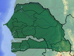
Yof Bay (French: Baie de Yoff) is a bay on the north side of the Cap-Vert peninsula, directly north of the city centre of Dakar, Senegal. It stretches southwest from the town Kayar to Yoff, a suburb of Dakar.[1] The bay opens towards the north and lies in the area of the westernmost point of Africa. Small Île de Yoff lies in the NW corner of the bay.[2]
Further reading
[edit]- Les Yoffois et leur environnement naturel : pêche, agriculture et territoire. in Richard Dumez and Moustapha Kâ. Yoff Le Territoire Assiégé: Un village lébou dans la banlieue de Dakar. Dossiers régions côtières et petites îles 7. Unesco (2000) [dead link]
References
[edit]- ^ Sailing Directions (Enroute), Pub. 143: West Coast of Europe and Northwest Africa (PDF). Sailing Directions. United States National Geospatial-Intelligence Agency. 2017. p. 283.
- ^ "Baie de Yof". Mapcarta. Retrieved 16 October 2016.


 French
 Deutsch