St John's Wood (Westminster)
| St John's Wood | |
|---|---|
| Saint John's Wood | |
 | |
| Stato | |
| Regione | |
| Città | Londra |
| Distretto | Città di Westminster |
| Altri quartieri | Aldwych, Bayswater, Belgravia, Covent Garden, Chinatown, Fitzrovia, Hyde Park, Kilburn, Knightsbridge, Lisson Grove, Little Venice, Maida Vale, Marylebone, Mayfair, Millbank, Paddington, Paddington Green, Pimlico, Queen's Park, St James's, Soho |
| Codice postale | NW8 |
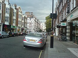
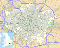
Saint John's Wood è un quartiere nella zona nord di Londra, Inghilterra, parte della Città di Westminster per il 98% del suo territorio, e per la restante parte di Camden.
Si estende dalla zona nord ovest di Regent's Park a Marylebone, fino a Edgware Road a Paddington e fino alla zona Swiss Cottage di Hampstead.[1][2]
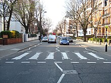
La zona è servita dall'omonima stazione della metropolitana di Londra. Nel quartiere sono presenti i celebri Abbey Road Studios, meta di turisti e appassionati dei Beatles, anche per la presenza nelle vicinanze delle strisce pedonali immortalate sulla celebre copertina dell'omonimo album Abbey Road.
Storia
[modifica | modifica wikitesto]Principali luoghi di culto
[modifica | modifica wikitesto]
- Abbey Road Baptist Church (Chiesa battista)
- St John's Wood Church (Chiesa anglicana)
- St Mark's Church, Hamilton Terrace (Chiesa anglicana)
- The Church of Our Lady (Chiesa cattolica)
- St John’s Wood United Synagogue (Sinagoga)
- The Liberal Jewish Synagogue (Sinagoga)
- The New London Synagogue (Sinagoga)
- Saatchi Shul (Sinagoga)
Istruzione
[modifica | modifica wikitesto]- 3 House Club
- Robinsfield Infant School
- Saint Christina's Primary School
- Barrow Hill Junior School
- George Elliot Primary School
- Quintin Kynaston Community Academy
- The American School in London
- Arnold House School
Infrastrutture e trasporti
[modifica | modifica wikitesto]Note
[modifica | modifica wikitesto]- ^ Camden Council: St John's Wood (East and West) conservation area appraisal and management strategy at 1.1 measures "3.83 hectares" otherwise the area is in Westminster and at 5.3 "Eyre's estate" [approximately equal in size] measured 500 acres, su camden.gov.uk. URL consultato il 27 marzo 2018.
- ^ Westminster Council: St John's Wood Conservation Area Appraisal: 3.6 Sale of land in St John’s Wood by the Crown began in the early 18th century. Henry Samuel Eyre acquired the largest portion in 1732: a 500 acre estate that stretched roughly from what is now Rossmore Road to Swiss Cottage, bounded by Hamilton Terrace to the west and Avenue Road to the east. (PDF), su transact.westminster.gov.uk. URL consultato il 27 marzo 2018 (archiviato dall'url originale il 26 febbraio 2021).
Altri progetti
[modifica | modifica wikitesto] Wikimedia Commons contiene immagini o altri file su St John's Wood


 French
 Deutsch