| Object | Bouwjaar | Architect | Locatie | Coördinaten | Nr. | Afbeelding |
| stadsboerderij (vakwerk) | 18e eeuw | | Bastionstraat 2 | 52° 2' 37" NB, 6° 37' 3" OL | 1586/GL01 | 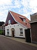 stadsboerderij (vakwerk) stadsboerderij (vakwerk) |
| Voormalig woonhuis/bankgebouw | ca. 1880 | | Beltrumsestraat 3-5 a-e | 52° 2' 33" NB, 6° 36' 59" OL | 1586/GL02 | 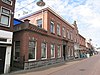 Voormalig woonhuis/bankgebouw Voormalig woonhuis/bankgebouw |
| woonhuis/winkelpand, eclectisme | ca. 1880 | | Beltrumsestraat 14 | 52° 2' 34" NB, 6° 36' 57" OL | 1586/GL03 |  woonhuis/winkelpand, eclectisme woonhuis/winkelpand, eclectisme |
| woonhuis/winkelpand | ca. 1910-'20 | | Beltrumsestraat 15 | 52° 2' 33" NB, 6° 36' 57" OL | 1586/GL04 |  woonhuis/winkelpand woonhuis/winkelpand |
| woonhuis, eclectisme | ca. 1880 | | Beltrumsestraat 16 | 52° 2' 34" NB, 6° 36' 56" OL | 1586/GL05 |  woonhuis, eclectisme woonhuis, eclectisme |
| bakkerij | 1910 | | Beltrumsestraat 28 | 52° 2' 34" NB, 6° 36' 53" OL | 1586/GL06 | 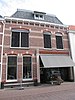 bakkerij bakkerij |
| woonhuis/winkelpand, eclectisme | 1850 | | Beltrumsestraat 33 | 52° 2' 33" NB, 6° 36' 52" OL | 1586/GL07 |  woonhuis/winkelpand, eclectisme woonhuis/winkelpand, eclectisme |
| woonhuis/winkelpand: Huys De Polvertoren | ca. 1875 | | Beltrumsestraat 42 | 52° 2' 34" NB, 6° 36' 48" OL | 1586/GL08 | 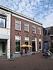 woonhuis/winkelpand: Huys De Polvertoren woonhuis/winkelpand: Huys De Polvertoren |
| woonhuis/winkelpand, eclectisme | 1850/1875 | | Beltrumsestraat 44 46 | 52° 2' 34" NB, 6° 36' 48" OL | 1586/GL09 | 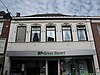 woonhuis/winkelpand, eclectisme woonhuis/winkelpand, eclectisme |
| winkelpand, eclectisme | ca. 1870 | | Beltrumsestraat 45 | 52° 2' 33" NB, 6° 36' 49" OL | 1586/GL10 |  winkelpand, eclectisme winkelpand, eclectisme |
| | | | Beltrumsestraat 51 53 | 52° 2' 32" NB, 6° 36' 47" OL | 1586/ | 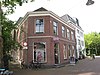 |
| woonhuis/winkelpand (drogisterij) | ca. 1910 | | Beltrumsestraat 54 | 52° 2' 33" NB, 6° 36' 48" OL | 1586/GL11 |  woonhuis/winkelpand (drogisterij) woonhuis/winkelpand (drogisterij) |
| brugleuning over de gracht | ca. 1832 | | Beltrumsestraat | 52° 2' 31" NB, 6° 36' 45" OL | 1586/GL12 |  brugleuning over de gracht brugleuning over de gracht |
| boerderij Scheurlink | 1926-1927 | | Boerijendijk 2 | 52° 2' 59" NB, 6° 38' 19" OL | 1586/GL13 | 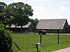 boerderij Scheurlink boerderij Scheurlink |
| woonhuis | ca. 1900 | | Borculoseweg 13 | 52° 2' 34" NB, 6° 36' 38" OL | 1586/GL14 | 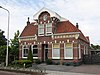 woonhuis woonhuis |
| directeursvilla Adriana, neo-klassiek, Um 1800-stijl | 1909 | | Eibergseweg 1 | 52° 2' 41" NB, 6° 37' 4" OL | 1586/GL15 |  directeursvilla Adriana, neo-klassiek, Um 1800-stijl Meer afbeeldingen directeursvilla Adriana, neo-klassiek, Um 1800-stijl Meer afbeeldingen |
| woonhuis | ca. 1830-'50 | | Ganzenmarkt 6 | 52° 2' 30" NB, 6° 36' 57" OL | 1586/GL16 |  woonhuis woonhuis |
| woonhuis/winkelpand, eclectisme | ca. 1900 | | Ganzenmarkt 7 | 52° 2' 29" NB, 6° 36' 57" OL | 1586/GL17 | 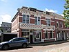 woonhuis/winkelpand, eclectisme woonhuis/winkelpand, eclectisme |
| woonhuis | 19e eeuw | | Goudsmitstraat 6 | 52° 2' 32" NB, 6° 36' 54" OL | 1586/GL18 |  woonhuis woonhuis |
| woonhuis, chaletstijl | 19e eeuw | | Goudsmitstraat 10 | 52° 2' 32" NB, 6° 36' 55" OL | 1586/GL19 |  woonhuis, chaletstijl woonhuis, chaletstijl |
| begraafplaats met lijkenhuisje en hekwerk (art deco) | 1910 | | Halve Maanweg 11 | 52° 2' 44" NB, 6° 37' 1" OL | 1586/GL20 |  begraafplaats met lijkenhuisje en hekwerk (art deco) begraafplaats met lijkenhuisje en hekwerk (art deco) |
| Voormalig woonhuis / Huis van Bewaring | 1865 | | Kevelderstraat 1 | 52° 2' 32" NB, 6° 37' 2" OL | 1586/GL21 |  Voormalig woonhuis / Huis van Bewaring Voormalig woonhuis / Huis van Bewaring |
| woonhuis/café Geboortehuys Grolsch | ca. 1860 | | Kevelderstraat 15 17/19 | 52° 2' 30" NB, 6° 37' 0" OL | 1586/GL22 | 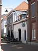 woonhuis/café Geboortehuys Grolsch woonhuis/café Geboortehuys Grolsch |
| woonhuis / vm bakkerij, eclectisme | 1880-1890 | | Kevelderstraat 21 23 | 52° 2' 30" NB, 6° 36' 60" OL | 1586/GL23 |  woonhuis / vm bakkerij, eclectisme woonhuis / vm bakkerij, eclectisme |
| woonhuis/winkelpand (vakwerk) | 18e eeuw | | Kevelderstraat 24 | 52° 2' 30" NB, 6° 36' 59" OL | 1586/GL24 |  woonhuis/winkelpand (vakwerk) woonhuis/winkelpand (vakwerk) |
| woonhuis | ca. 1850 | | Lepelstraat 21 | 52° 2' 32" NB, 6° 36' 48" OL | 1586/GL25 |  woonhuis woonhuis |
| woonhuis | ca. 1910-'20 | | Lichtenvoordseweg 35 | 52° 2' 14" NB, 6° 37' 5" OL | 1586/GL26 | 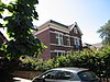 woonhuis woonhuis |
| woonhuis/bakkerij (vakwerk) | 17e eeuw | | Lievelderstraat 12 | 52° 2' 29" NB, 6° 37' 2" OL | 1586/GL27 | 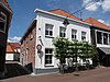 woonhuis/bakkerij (vakwerk) woonhuis/bakkerij (vakwerk) |
| woonhuis/winkelpand (vakwerk) | 1650 | | Lievelderstraat 13 a-e | 52° 2' 28" NB, 6° 37' 4" OL | 1586/GL28 |  woonhuis/winkelpand (vakwerk) woonhuis/winkelpand (vakwerk) |
| woonhuis/winkelpand (vakwerk) | 17e eeuw | | Lievelderstraat 20 | 52° 2' 28" NB, 6° 37' 3" OL | 1586/GL29 |  woonhuis/winkelpand (vakwerk) woonhuis/winkelpand (vakwerk) |
| woonhuis (vakwerk) | 17e eeuw | | Lievelderstraat 27 | 52° 2' 27" NB, 6° 37' 4" OL | 1586/GL30 | 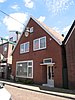 woonhuis (vakwerk) woonhuis (vakwerk) |
| woonhuis | ca. 1870-'80 | | Lievelderstraat 48 | 52° 2' 21" NB, 6° 37' 7" OL | 1586/GL31 | 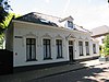 woonhuis woonhuis |
| woonhuis | ca. 1870-'80 | | Lievelderstraat 49 | 52° 2' 23" NB, 6° 37' 6" OL | 1586/GL32 |  woonhuis woonhuis |
| Theekoepel, inrijhek, bouwfragmenten, buitentuin Pomona | 1902 | | Marhulzenweg | 52° 2' 37" NB, 6° 37' 15" OL | 1586/GL33 |  Theekoepel, inrijhek, bouwfragmenten, buitentuin Pomona Theekoepel, inrijhek, bouwfragmenten, buitentuin Pomona |
| Woonhuis/winkelpand | 19e eeuw | | Markt 2 2A | 52° 2' 33" NB, 6° 37' 3" OL | 1586/GL34 |  Woonhuis/winkelpand Woonhuis/winkelpand |
| Stadhuis van Groenlo | 1875 | | Mattelierstraat 2 | 52° 2' 32" NB, 6° 37' 2" OL | 1586/GL35 | 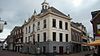 Stadhuis van Groenlo Meer afbeeldingen Stadhuis van Groenlo Meer afbeeldingen |
| Kerkhof met grafmonumenten | 18e eeuw | | Mattelierstraat 5 | 52° 2' 33" NB, 6° 37' 7" OL | 1586/GL36 |  Kerkhof met grafmonumenten Meer afbeeldingen Kerkhof met grafmonumenten Meer afbeeldingen |
| Flentrop-orgel, neobarok in de Oude Calixtuskerk | 1951 | | Mattelierstraat 5 | 52° 2' 32" NB, 6° 37' 5" OL | 1586/GL37 | Upload foto |
| winkelpanden/opslag | 19e eeuw | | Mattelierstraat 8 | 52° 2' 31" NB, 6° 37' 3" OL | 1586/GL38 | 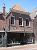 winkelpanden/opslag winkelpanden/opslag |
| Woonhuis/winkelpand | 19e eeuw | | Mattelierstraat 6 | 52° 2' 32" NB, 6° 37' 3" OL | 1586/GL39 |  Woonhuis/winkelpand Woonhuis/winkelpand |
| Voormalig Nederlands-Hervormd pastorie, kantoor | 1904 | | Mattelierstraat 19 | 52° 2' 29" NB, 6° 37' 7" OL | 1586/GL40 |  Voormalig Nederlands-Hervormd pastorie, kantoor Voormalig Nederlands-Hervormd pastorie, kantoor |
| winkelpand | 19e eeuw | | Mattelierstraat 31 | 52° 2' 28" NB, 6° 37' 9" OL | 1586/GL41 |  winkelpand winkelpand |
| Voormalig meesterswoning met school | ca. 1880 | | Mattelierstraat 33 | 52° 2' 28" NB, 6° 37' 9" OL | 1586/GL42 | Voormalig meesterswoning met school |
| woonhuis/winkelpand | 18e eeuw | | Nieuwestraat 3 | 52° 2' 35" NB, 6° 37' 1" OL | 1586/GL43 |  woonhuis/winkelpand woonhuis/winkelpand |
| woonhuis | ca. 1900 | | Nieuwestraat 5 | 52° 2' 35" NB, 6° 37' 2" OL | 1586/GL44 |  woonhuis woonhuis |
| helft van een dubbel woonhuis | 20e eeuw | | Nieuwstad 3 | 52° 2' 28" NB, 6° 36' 59" OL | 1586/GL45 | 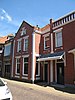 helft van een dubbel woonhuis helft van een dubbel woonhuis |
| helft van een dubbel woonhuis | 20e eeuw | | Nieuwstad 5 | 52° 2' 28" NB, 6° 36' 59" OL | 1586/GL46 |  helft van een dubbel woonhuis helft van een dubbel woonhuis |
| woonhuis/winkelpand | 19e eeuw | | Nieuwstad 8 | 52° 2' 28" NB, 6° 36' 58" OL | 1586/GL47 |  woonhuis/winkelpand woonhuis/winkelpand |
| woonhuis | 19e eeuw | | Nieuwstad 13 | 52° 2' 27" NB, 6° 36' 60" OL | 1586/GL48 |  woonhuis woonhuis |
| woonhuis | 19e eeuw | | Nieuwstad 15 | 52° 2' 27" NB, 6° 36' 60" OL | 1586/GL49 | 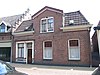 woonhuis woonhuis |
| Voormalig klooster/weeshuis/school | 1866/1930 | | Nieuwstad 14-60 | 52° 2' 25" NB, 6° 36' 60" OL | 1586/GL50 |  Voormalig klooster/weeshuis/school Voormalig klooster/weeshuis/school |
| Voormalig bakkerij / woonhuis | 18e eeuw | | Notenboomstraat 10 | 52° 2' 36" NB, 6° 37' 0" OL | 1586/GL51 |  Voormalig bakkerij / woonhuis Voormalig bakkerij / woonhuis |
| stadsboerderij (vakwerk) | 18e eeuw | | Notenboomstraat 13 | 52° 2' 35" NB, 6° 36' 59" OL | 1586/GL52 |  stadsboerderij (vakwerk) stadsboerderij (vakwerk) |
| rechterhelft dubbel woonhuis | 17e eeuw/1900 | | Notenboomstraat 14 | 52° 2' 36" NB, 6° 36' 59" OL | 1586/GL53 | 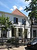 rechterhelft dubbel woonhuis rechterhelft dubbel woonhuis |
| stadsboerderij (vakwerk) | 18e eeuw | | Notenboomstraat 21 | 52° 2' 36" NB, 6° 36' 57" OL | 1586/GL54 |  stadsboerderij (vakwerk) stadsboerderij (vakwerk) |
| Boerderij Panneman | 1930 | | Oude Borculoseweg 8 | 52° 3' 20" NB, 6° 36' 55" OL | 1586/GL55 |  Boerderij Panneman Boerderij Panneman |
| Boerderij Klein Stikken | 1936-1937 | | Oude Winterswijkseweg 47 | 52° 1' 51" NB, 6° 38' 22" OL | 1586/GL56 | 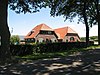 Boerderij Klein Stikken Boerderij Klein Stikken |
| Villa Banninghof, overgangsarchitectuur | 1916 | | Ruurloseweg 59 | 52° 2' 28" NB, 6° 36' 3" OL | 1586/GL57 | 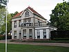 Villa Banninghof, overgangsarchitectuur Villa Banninghof, overgangsarchitectuur |
| School St. Joseph | 1890 | | Schralenstein 2 | 52° 2' 23" NB, 6° 37' 2" OL | 1586/GL58 |  School St. Joseph School St. Joseph |
| Stationsgebouw + woning type G.O.L.S. groot | 1886 | | Stationslaan 11 | 52° 2' 23" NB, 6° 37' 25" OL | 1586/GL59 |  Stationsgebouw + woning type G.O.L.S. groot Meer afbeeldingen Stationsgebouw + woning type G.O.L.S. groot Meer afbeeldingen |
| Kantoor/villa De Linde, overgangsarchitectuur | 1907 | | Winterswijkseweg 26 | 52° 2' 14" NB, 6° 37' 19" OL | 1586/GL60 |  Kantoor/villa De Linde, overgangsarchitectuur Kantoor/villa De Linde, overgangsarchitectuur |
| Boerderij Nieuw Wallerbosch | 1940 | | Winterswijkseweg 64 | 52° 1' 53" NB, 6° 37' 33" OL | 1586/GL61 | 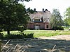 Boerderij Nieuw Wallerbosch Boerderij Nieuw Wallerbosch |
| twee woonhuizen met achterhuis Ruimzicht en Alberdine | 1910/1918 | | Winterswijkseweg 76 78 | 52° 1' 11" NB, 6° 38' 15" OL | 1586/GL62 |  twee woonhuizen met achterhuis Ruimzicht en Alberdine twee woonhuizen met achterhuis Ruimzicht en Alberdine |
| Kapel Molenberg | 1936 | | Ziekenhuisstraat 16 | 52° 2' 26" NB, 6° 36' 50" OL | 1586/GL64 | 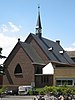 Kapel Molenberg Kapel Molenberg |

 French
 Deutsch


_-_Groenlo_-_20091869_-_RCE.jpg)


