Clipperton Island - Simple English Wikipedia, the free encyclopedia
Native name: Île de Clipperton, Isla de la Pasión | |
|---|---|
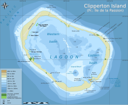
 Clipperton Island with lagoon, showing depths in metres | |
 | |
| Geography | |
| Location | Pacific Ocean |
| Coordinates | 10°18′N 109°13′W / 10.300°N 109.217°W |
| Archipelago | None |
| Area | 6 km2 (2.3 sq mi) |
| Highest elevation | 29 m (95 ft) |
| Highest point | Clipperton Rock |
| Administration | |
| Minor territory | Île de Clipperton |
| Demographics | |
| Population | Non Applicable (1945) |
| Additional information | |
| Time zone | |

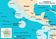
Clipperton Island is an uninhabited atoll in the Pacific Ocean, off the coast of Central America. It is about 6 square kilometres (2.3 sq mi) in size and is an overseas territory of France. In Spanish, it is known as Isla de la Pasión. It is about 1,280 kilometres (800 mi) from Acapulco. The nearest French settlements is Papeete, 5,400 kilometres (3,400 mi) away. Paris is 10,677 kilometres (6,634 mi) away. Clipperton Island is about 945 km (587 mi; 510 nmi) south-east of Socorro Island in the Revillagigedo Archipelago, which is the nearest land.
French explorers found the island in 1711. In 1858, it was made a part of Tahiti. Tahiti was a French protectorate, at the time. There was a dispute between Mexico, and France over the island. In 1909, Victor Emmanuel III of Italy was chosen to decide the issue. In 1931, he decided that the island should belong to France. Despite this, Clipperton was uninhabited most of the time. Since the end of the Second World War, Clipperton has mostly be used for scientific expeditions. There is a weather station, and a small landing strip for airplanes.
Today, the territory is administered from Papeete. Probably between 1840 and 1858, the lagoon closed itself, likely because of thunderstorms. Today, it is a freshwater lagoon. It is the only known freshwater lagoon in the world.[1][2]
In 2011, a postage stamp was made to commemorate the discovery of the island. It had a value of 1€. Officially, the postage stamps of French Polynesia can be used. The island has the postal code 98799; there is no post office, though.[3]
Geography
[change | change source]The island is low-lying and barren, with some scattered grasses, and a few of coconut trees.[4][5]
References
[change | change source]- ↑ Hellduck (2013-09-06). "La Collection Cousteau 71/90 - Clipperton île de la solitude (1980)". Retrieved 2016-01-27..
- ↑ Luc Chaillot (12 June 2016). "Clipperton, l'île oubliée de la République". L'Est républicain..
- ↑ Jullien, Pierre (2020-04-17). "Clipperton : une " passion " américano-franco-mexicaine" [Clipperton: An American-Franco-Mexican "Passion"]. Le Monde (in French). Archived from the original on 31 July 2022. Retrieved 2022-07-31.
- ↑ Sacotte, Jean-Charles (March 1, 1978). "Dx pedition on Clipperton". 1978 Dxpedition to Clipperton Atoll. Translated by Jeanne, Sylvie. Clipperton DX Club. Archived from the original on 2008-12-29. Retrieved 2023-04-01.
- ↑ Jost, Xenia; Jost, Christian H.; Meyer, Jean-Yves (2019-06-06). "Flora and Vegetation of Clipperton (La Passion) Atoll, North-Eastern Pacific Ocean: Three Centuries of Changes and Recent Plant Dynamics". Atoll Research Bulletin (623): 1–31. doi:10.5479/si.0077-5630.623. ISSN 0077-5630. S2CID 197962758. Archived from the original on 10 December 2020. Retrieved 1 April 2023.
Other websites
[change | change source]| Definitions from Wiktionary | |
| Media from Commons | |
| News stories from Wikinews | |
| Quotations from Wikiquote | |
| Source texts from Wikisource | |
| Textbooks from Wikibooks | |
| Travel guide from Wikivoyage | |
| Learning resources from Wikiversity | |


 French
 Deutsch