Mpumalanga - Simple English Wikipedia, the free encyclopedia
Mpumalanga iMpumalanga (in Swazi and Zulu) IMpumalanga (in Southern Ndebele) | |
|---|---|
| Motto: Omnia labor vincit (Labour will conquer all) | |
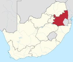
 Location of Mpumalanga in South Africa | |
| Country | South Africa |
| Established | 27 April 1994 |
| Capital | Mbombela (Nelspruit) |
| Districts | |
| Government | |
| • Type | Parliamentary system |
| • Premier | Refilwe Mtsweni-Tsipane (ANC) |
| • Legislature | Mpumalanga Provincial Legislature |
| Area [1]: 9 | |
| • Total | 76,495 km2 (29,535 sq mi) |
| • Rank | 8th in South Africa |
| Highest elevation | 2,331 m (7,648 ft) |
| Population | |
| • Total | 4,039,939 |
| • Estimate (2018) | 4,523,900 |
| • Rank | 6th in South Africa |
| • Density | 53/km2 (140/sq mi) |
| • Rank | 3rd in South Africa |
| Population groups [1]: 21 | |
| • Black African | 90.7% |
| • White | 7.5% |
| • Coloured | 0.9% |
| • Indian or Asian | 0.7% |
| Languages [1]: 25 | |
| • Swazi | 27.7% |
| • Zulu | 24.1% |
| • Tsonga | 10.4% |
| • Southern Ndebele | 10.1% |
| • Northern Sotho | 9.3% |
| • Afrikaans | 7.2% |
| • Southern Sotho | 3.5% |
| • English | 3.1% |
| Time zone | UTC+2 (SAST) |
| ISO 3166 code | ZA-MP |
| Website | www.mpumalanga.gov.za |
Mpumalanga is a province in South Africa. It is one of South Africa's 9 provinces. The name of the province means 'where the sun rises'.[3][4][5]
References
[change | change source]- ↑ 1.0 1.1 1.2 1.3 Census 2011: Census in brief (PDF). Pretoria: Statistics South Africa. 2012. ISBN 9780621413885. Archived (PDF) from the original on 13 May 2015.
- ↑ "Mid-year population estimates, 2018" (PDF). Statistics South Africa. 31 July 2018. Retrieved 29 July 2018.
- ↑ Three dead‚ 20 injured in accident on N12 in Mpumalanga The Times
- ↑ South Africa shock over bus collision in Mpumalanga - BBC News
- ↑ South Africa coffin case: White farmers convicted - BBC News


 French
 Deutsch