| Site | Fotoğraf | Konum | Ölçüt | Alan
ha (acre)
| Yıl | Açıklama |
| Aachen Katedrali | 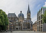 | GermanyAachen,

50°46′28″K 6°5′4″D / 50.77444°K 6.08444°D / 50.77444; 6.08444 (Aachen Cathedral) | Cultural:GerAac
(i), (ii),
(iv), (vi) | 02 (4,9) | 1978 | [3] |
| Lorsch'taki Manastır ve Altermünster | 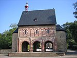 | GermanyLorsch,
49°39′13″K 8°34′7″D / 49.65361°K 8.56861°D / 49.65361; 8.56861 (Abbey and Altenmünster of Lorsch) | Cultural:GerLor
(iii), (iv) | 334 (830) | 1991 | [4] |
| Saint-Savin-sur-Gartempe Manastır Kilisesi | 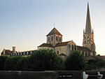 | FranceVienne,

46°33′53″K 0°51′58″D / 46.56472°K 0.86611°D / 46.56472; 0.86611 (Abbey Church of Saint-Savin-sur-Gartempe) | Cultural:FraVie
(i), (iii) | 161 (400) | 1983 | [5] |
| Amiens Katedrali |  | FranceAmiens,
49°53′42″K 2°18′6″D / 49.89500°K 2.30167°D / 49.89500; 2.30167 (Amiens Cathedral) | Cultural:FraAmi
(i), (ii) | 154 (380) | 1981 | [6] |
| Bend of Boyne Arkeolojik Topluluğu |  | IrelandCounty Meath,

53°41′30.012″K 6°27′0″B / 53.69167000°K 6.45000°B / 53.69167000; -6.45000 (Archaeological Ensemble of the Bend of the Boyne) | Cultural:IreCouMea
(i), (iii), (iv) | 770 (1.900) | 1993 | [7] |
| Le Corbusier'in Mimari Çalışmaları, Modern Hareket'a Üstün Bir Katkı |  | Belgium * *
 * *
*
*
 * *
 * *
 * *
46°28′06″K 6°49′46″D / 46.46833°K 6.82944°D / 46.46833; 6.82944 (Architectural Work of Le Corbusier, an Outstanding Contribution to the Modern Movement) | Cultural:BelArc
(i), (ii), (vi) | 98 (240) | 2016 | [8] |
| Arles, Roman ve Romanesk Anıtları |  | FranceBouches-du-Rhône,
43°40′40″K 4°37′51″D / 43.67778°K 4.63083°D / 43.67778; 4.63083 (Arles, Roman and Romanesque Monuments) | Cultural:FraArl
(ii), (iv) | 65 (160) | 1981 | [9] |
| Weimar ve Dessau'daki Bauhaus ve Bağlantılı Alanlar |  | GermanyDessau ve Weimar
50°58′29″K 11°19′46″D / 50.97472°K 11.32944°D / 50.97472; 11.32944 (Bauhaus and its sites in Weimar and Dessau) | Cultural:GerBer1
(ii), (iv), (vi) | — | 1996 | [10] |
| Beemster Polder; Kurutulan Sulak Alanlar |  | NetherlandsNorth Holland,

52°32′56″K 4°54′40″D / 52.54889°K 4.91111°D / 52.54889; 4.91111 (Droogmakerij de Beemster (Beemster Polder)) | Cultural:NetNorBeem
(i), (ii), (iv) | — | 1999 | [11] |
| Belçika ve Fransa'daki Çan Kuleleri |  | Belgium*
*
50°10′28″K 3°13′53″D / 50.17444°K 3.23139°D / 50.17444; 3.23139 (Belfries of Belgium and France) | Cultural:Belg1
(ii), (iv) | — | 1999 | [12] |
| Müstair'deki St. John Benediktin Manastırı |  | SwitzerlandMüstair,
46°37′46″K 10°26′52″D / 46.62944°K 10.44778°D / 46.62944; 10.44778 (Benedictine Convent of St John at Müstair) | Cultural:SwiMus
(iii) | 2.036 (5.030) | 1983 | [13] |
| Bergpark Wilhelmshöhe |  | GermanyKassel,
51°18′57″K 9°23′35″D / 51.31583°K 9.39306°D / 51.31583; 9.39306 (Bergpark Wilhelmshöhe in Kassel) | Cultural:GerKas
(iii), (iv) | 559 (1.380) | 2013 | [14] |
| Berlin Modernizm Konutları |  | GermanyBerlin,
52°26′54″K 13°27′0″D / 52.44833°K 13.45000°D / 52.44833; 13.45000 (Berlin Modernism Housing Estates) | Cultural:GerBer2
(ii), (iv) | 88 (220) | 2008 | [15] |
| Blaenavon Sanayi Bölgesi |  | United KingdomTorfaen, Galler,

51°46′35″K 3°5′17″B / 51.77639°K 3.08806°B / 51.77639; -3.08806 (Blaenavon Industrial Landscape) | Cultural:UniTorf
(iii), (iv) | 3.290 (8.100) | 2000 | [16] |
| Blenheim Sarayı |  | United KingdomWoodstock, İngiltere,
51°50′31″K 1°21′41″B / 51.84194°K 1.36139°B / 51.84194; -1.36139 (Blenheim Palace) | Cultural:UniWoo
(ii), (iv) | — | 1987 | [17] |
| Bordeaux, Port of the Moon |  | FranceGironde,
44°50′20″K 0°34′20″D / 44.83889°K 0.57222°D / 44.83889; 0.57222 (Bordeaux, Port of the Moon) | Cultural:FraGir1
(ii), (iv) | 1.731 (4.280) | 2007 | [18] |
| Bourges Katedrali |  | FranceBourges,
47°4′56″K 2°23′54″D / 47.08222°K 2.39833°D / 47.08222; 2.39833 (Bourges Cathedral) | Cultural:FraBou
(i), (iv) | 085 (210) | 1992 | [19] |
| Canal du Midi |  | FranceSouthern France,
43°36′41″K 1°24′59″D / 43.61139°K 1.41639°D / 43.61139; 1.41639 (Canal du Midi) | Cultural:FraSou1
(i), (ii),
(iv), (vi) | 1.172 (2.900) | 1996 | [20] |
| Canterbury Katedrali, Aziz Augustine Manastırı ve Azize Martin Kilisesi |  | United KingdomCanterbury, İngiltere,
51°16′48″K 1°4′59″D / 51.28000°K 1.08306°D / 51.28000; 1.08306 (Canterbury Cathedral, St Augustine's Abbey, and St Martin's Church) | Cultural:UniCan
(i), (ii), (vi) | 18 (44) | 1988 | [21][22][23] |
| Carolingian Westwork ve Civitas Corvey |  | GermanyHöxter, Almanya,
51°46′42″K 9°24′37″D / 51.77833°K 9.41028°D / 51.77833; 9.41028 (Carolingian Westwork and Civitas Corvey) | Cultural:GerCar
(ii), (iii), (iv) | 12 (30) | 2014 | [24] |
| Gwynedd'deki Kral Edward'ın Kaleleri ve Kent Surları | 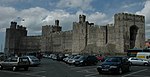 | United KingdomGwynedd, Galler,
53°8′23″K 4°16′37″B / 53.13972°K 4.27694°B / 53.13972; -4.27694 (Castles and Town Walls of King Edward in Gwynedd) | Cultural:UniGwy
(i), (iii), (iv) | 6 (15) | 1986 | [25][26] |
| Brühl'deki Augustusburg ve Falkenlust Sarayları |  | GermanyBrühl, Kuzey Ren-Vestfalya,
50°49′30″K 6°54′35″D / 50.82500°K 6.90972°D / 50.82500; 6.90972 (Castles of Augustusburg and Falkenlust at Brühl) | Cultural:GerBru
(ii), (iv) | 89 (220) | 1984 | [27] |
| Reims'teki Notre-Dame Katedrali, Eski Saint-Remi Manastırı ve Tau Sarayı | 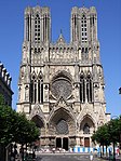 | FranceReims,
49°15′12″K 4°1′58″D / 49.25333°K 4.03278°D / 49.25333; 4.03278 (Cathedral of Notre-Dame, Former Abbey of Saint-Remi and Palace of Tau, Reims) | Cultural:FraRei
(i), (ii), (vi) | 416 (1.030) | 1991 | [28] |
| Causses ve Cévennes, Akdeniz Tarımsal Pastoral Kültürel Peyzajı |  | FranceSouthern France,
44°13′13″K 3°28′23″D / 44.22028°K 3.47306°D / 44.22028; 3.47306 (The Causses and the Cévennes) | Cultural:FraSou2
(iii), (v) | 302.319 (747.050) | 2011 | [29] |
| Svabya Alpleri'ndeki Mağaralar ve Buz Devri Sanatları |  | GermanyAch and Lone Valleys,
48°23′16″K 9°45′56″D / 48.38778°K 9.76556°D / 48.38778; 9.76556 (Ach Valley)
48°32′56″K 10°10′32″D / 48.54889°K 10.17556°D / 48.54889; 10.17556 (Lone Valley) | Cultural:GerJur
(iii) | 4.621 (11.420) | 2017 | [30] |
| Chartres Katedrali | 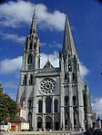 | FranceChartres,
48°26′51″K 1°29′14″D / 48.44750°K 1.48722°D / 48.44750; 1.48722 (Chartres Cathedral) | Cultural:FraCha
(i), (ii), (iv) | 106 (260) | 1979 | [31] |
| La Chaux-de-Fonds/Le Locle Saatçilik Şehri Planlaması |  | SwitzerlandCanton of Neuchâtel,
47°6′14″K 6°49′58″D / 47.10389°K 6.83278°D / 47.10389; 6.83278 (La Chaux-de-Fonds/Le Locle, Watchmaking Town Planning.) | Cultural:SwiNeu
(iv) | 284 (700) | 2009 | [32] |
| Champagne yamaçları, evleri ve kilerleri |  | FranceMarne,
49°04′39″K 3°56′46″D / 49.07750°K 3.94611°D / 49.07750; 3.94611 (Champagne hillsides, houses and cellars) | Cultural:FraMar
(iii), (iv), (vi) | 1.101 (2.720) | 2015 | [33] |
| Fontenay Sistersiyen Manastırı |  | FranceMarmagne, Côte-d'Or,
47°38′22″K 4°23′21″D / 47.63944°K 4.38917°D / 47.63944; 4.38917 (Cistercian Abbey of Fontenay) | Cultural:FraMar
(iv) | 577 (1.430) | 1981 | [34] |
| Climats, Burgonya'nın bağları |  | FranceCôte-d'Or,
47°03′29″K 4°51′52″D / 47.05806°K 4.86444°D / 47.05806; 4.86444 (Climats, terroirs of Burgundy) | Cultural:FraCot
(iii), (v) | 13.219 (32.660) | 2015 | [35] |
| Tarihi Bath Şehri | 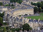 | United KingdomSomerset, İngiltere,
51°22′53″K 2°21′31″B / 51.38139°K 2.35861°B / 51.38139; -2.35861 (City of Bath) | Cultural:UniSom
(i), (ii), (iv) | 2.900 (7.200) | 1987 | [36] |
| Tarihi Graz Şehri ve Eggenberg Şatosu |  | AustriaStyria,

47°4′27″K 15°23′30″D / 47.07417°K 15.39167°D / 47.07417; 15.39167 (City of Graz – Historic Centre and Schloss Eggenberg) | Cultural:AusSty
(ii), (iv) | — | 1999 | [37] |
| Tarihi Lüksemburg Şehri |  | Luxembourg
49°36′36″K 6°7′59.988″D / 49.61000°K 6.13333000°D / 49.61000; 6.13333000 (City of Luxembourg: its Old Quarters and Fortifications) | Cultural:Luxembourg
(iv) | 30 (74) | 1994 | [38] |
| Klasik Weimar |  | GermanyTüringiya,
50°58′39″K 11°19′43″D / 50.97750°K 11.32861°D / 50.97750; 11.32861 (Classical Weimar) | Cultural:GerWei
(iii), (vi) | — | 1998 | [39] |
| Quedlinburg Eski Şehri, Kalesi ve Üniversite Kilisesi |  | GermanyHarz,
51°47′0″K 11°9′0″D / 51.78333°K 11.15000°D / 51.78333; 11.15000 (Collegiate Church, Castle and Old Town of Quedlinburg) | Cultural:GerHar
(iv) | 90 (220) | 1994 | [40] |
| Köln Katedrali | 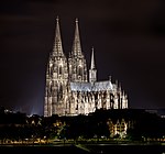 | GermanyKöln,
50°56′28″K 6°57′26″D / 50.94111°K 6.95722°D / 50.94111; 6.95722 (Cologne Cathedral) | Cultural:GerCol
(i), (ii), (iv) | — | 1996 | [41][42] |
| Aziz Gall Manastırı | 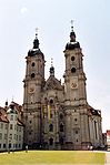 | SwitzerlandSt. Gallen,
47°25′24″K 9°22′40″D / 47.42333°K 9.37778°D / 47.42333; 9.37778 (Convent of St Gall) | Cultural:SwiStGal
(ii), (iv) | — | 1983 | [43] |
| Cornwall ve Batı Devon Madencilik Peyzajı | 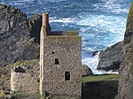 | United KingdomSouth West England,
50°8′10″K 5°23′1″B / 50.13611°K 5.38361°B / 50.13611; -5.38361 (Cornwall and West Devon Mining Landscape) | Cultural:UniSouCor
(ii), (iii), (iv) | 19,719 (48,73) | 2006 | [44] |
| Chauvet-Pont d'Arc Mağarası olarak bilinen dekore edilmiş Pont d'Arc Mağarası, Ardèche |  | FranceVallon-Pont-d'Arc,
44°23′20″K 4°24′59″D / 44.38889°K 4.41639°D / 44.38889; 4.41639 (Decorated Cave of Pont d’Arc, known as Grotte Chauvet-Pont d’Arc, Ardèche) | Cultural:FraDec
(i), (iii) | 9 (22) | 2014 | [45] |
| Amsterdam'ın Savunma Hattı |  | NetherlandsAmsterdam,
52°22′28″K 4°53′35″D / 52.37444°K 4.89306°D / 52.37444; 4.89306 (Defence Line of Amsterdam) | Cultural:NetAmsDef
(ii), (iv), (v) | 14.953 (36.950) | 1996 | [46] |
| Derwent Vadisi Değirmenleri |  | United KingdomDerbyshire, İngiltere,
53°1′44″K 1°29′17″B / 53.02889°K 1.48806°B / 53.02889; -1.48806 (Derwent Valley Mills) | Cultural:UniDer
(ii), (iv) | 1.229 (3.040) | 2001 | [47][48] |
| Dorset ve Doğu Devon Kıyıları | 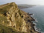 | United KingdomDorset, İngiltere,
50°42′20″K 2°59′23.6″B / 50.70556°K 2.989889°B / 50.70556; -2.989889 (Dorset and East Devon Coast) | Natural:UniEasDev
(viii) | 2.550 (6.300) | 2001 | [49] |
| Durham Kalesi ve Katedrali | 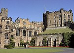 | United KingdomDurham, İngiltere,
54°46′29″K 1°34′34″B / 54.77472°K 1.57611°B / 54.77472; -1.57611 (Durham Castle and Cathedral) | Cultural:UniDur
(ii), (iv), (vi) | 879 (2.170) | 1986 | [50] |
| Lake District | 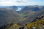 | United KingdomNorth West England,
54°28′36″K 3°4′57″B / 54.47667°K 3.08250°B / 54.47667; -3.08250 (The English Lake District) | Cultural:UniLak
(ii), (v), (vi) | 22.920.519 (56.637.840) | 2017 | [51] |
| Albi Piskoposluk Şehri |  | FranceTarn,
43°55′42″K 2°8′33″D / 43.92833°K 2.14250°D / 43.92833; 2.14250 (Cité épiscopale d'Albi) | Cultural:FraTar
(iv), (v) | 19 (47) | 2010 | [52] |
| Alfeld'deki Fagus Fabrikası | 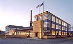 | GermanyAlfeld,
51°59′1″K 9°48′40″D / 51.98361°K 9.81111°D / 51.98361; 9.81111 (Fagus Factory in Alfeld) | Cultural:GerAlf
(ii), (iv) | 188 (460) | 2011 | [53] |
| Fertő/Neusiedl Kültürel Peyzajı |  | AustriaBurgenland ve Győr-Moson-Sopron County,
*
 * *
47°43′9.4″K 16°43′21.8″D / 47.719278°K 16.722722°D / 47.719278; 16.722722 (Fertö / Neusiedlersee Cultural Landscape) | Cultural:AusBur
(v) | 52 (130) | 2001 | [54] |
| Flaman Béguinages |  | BelgiumFlanders,
51°1′52″K 4°28′26″D / 51.03111°K 4.47389°D / 51.03111; 4.47389 (Flemish Béguinages) | Cultural:BelFla
(ii), (iii), (iv) | 60 (150) | 1998 | [55] |
| Forth Köprüsü |  | United Kingdomİskoçya,
56°0′3″K 3°23′23″B / 56.00083°K 3.38972°B / 56.00083; -3.38972 (Forth Bridge) | Cultural:UniFor
(i), (iv) | 75 (190) | 2015 | [56] |
| Vauban'ın Tahkimatı |  | France
50°16′57″K 2°45′32″D / 50.28250°K 2.75889°D / 50.28250; 2.75889 (Fortifications of Vauban) | Cultural:Fra1
(i), (ii), (iv) | 1.153 (2.850) | 2008 | [57] |
| Canal du Centre'deki Gemi Asansörleri |  | BelgiumLa Louvière,
50°28′52″K 4°8′14″D / 50.48111°K 4.13722°D / 50.48111; 4.13722 (The Four Lifts on the Canal du Centre) | Cultural:BelLaLou
(iii), (iv) | 67 (170) | 1998 | [58] |
| Tarihi Roma İmparatorluğu Surları:Yukarı Germanik-Rhaetya Surları |  | GermanyCentral Lowlands,
Northern England,
and Southern Germany
*
*
54°59′33″K 2°36′4″B / 54.99250°K 2.60111°B / 54.99250; -2.60111 (Frontiers of the Roman Empire) | Cultural:GerCen
(ii), (iii), (iv) | 527 (1.300) | 1987 | [59][60] |
| Dessau-Wörlitz'teki Bahçe Krallığı |  | GermanySaksonya-Anhalt,
51°50′33″K 12°25′15″D / 51.84250°K 12.42083°D / 51.84250; 12.42083 (Garden Kingdom of Dessau-Wörlitz) | Cultural:GerSax1
(ii), (iv) | 14.500 (36.000) | 2000 | [61] |
| Devler Kaldırımı |  | United KingdomCounty Antrim, Kuzey İrlanda,
55°15′0″K 6°29′7″B / 55.25000°K 6.48528°B / 55.25000; -6.48528 (Giant's Causeway and Causeway Coast) | Natural:UniCouAnt
(vii), (viii) | 70 (170) | 1986 | [62] |
| La Grand-Place, Brussels |  | BelgiumBrüksel,
50°50′48.048″K 4°21′9″D / 50.84668000°K 4.35250°D / 50.84668000; 4.35250 (La Grand-Place, Brussels) | Cultural:BelBru1
(ii), (iv) | 148 (370) | 1998 | [63] |
| Porto Körfezi: Calanques de Piana, Girolata Körfezi ve Scandola Doğa Koruma Alanı |  | FranceCorsica,
42°19′31″K 8°37′43.8″D / 42.32528°K 8.628833°D / 42.32528; 8.628833 (Gulf of Porto: Calanche of Piana, Gulf of Girolata, Scandola Reserve) | Natural:FraCor
(vii), (viii), (x) | 11.800 (29.000) | 1983 | [64] |
| Hallstatt-Dachstein ve Salzkammergut'un Kültürel Peyzajı |  | AustriaSalzkammergut,
47°33′34″K 13°38′47″D / 47.55944°K 13.64639°D / 47.55944; 13.64639 (Hallstatt-Dachstein / Salzkammergut Cultural Landscape) | Cultural:AusSal
(iii), (iv) | 28.446 (70.290) | 1997 | [65] |
| Hanseatik Dönemin Lübeck Şehri |  | GermanySchleswig-Holstein,
53°52′0″K 10°41′30″D / 53.86667°K 10.69167°D / 53.86667; 10.69167 (Hanseatic City of Lübeck) | Cultural:GerSch
(iv) | 81 (200) | 1987 | [66] |
| Heart of Neolithic Orkney |  | United KingdomMainland, İskoçya,
58°59′45.8″K 3°11′19″B / 58.996056°K 3.18861°B / 58.996056; -3.18861 (Heart of Neolithic Orkney) | Cultural:UniMai
(i), (ii),
(iii), (iv) | 15 (37) | 1999 | [67] |
| Avingon'un Tarihi Merkezi: Papalık Sarayı Piskoposluk Topluluğu ve Avignon Köprüsü |  | FranceVaucluse,
43°57′10″K 4°48′22″D / 43.95278°K 4.80611°D / 43.95278; 4.80611 (Historic Centre of Avignon) | Culture:FraVau
(i), (ii), (iv) | 82 (200) | 1995 | [68] |
| Tarihi Brugge Şehri |  | BelgiumWest Flanders,
51°12′32.076″K 3°13′30.972″D / 51.20891000°K 3.22527000°D / 51.20891000; 3.22527000 (Historic Centre of Brugge) | Cultural:BelWes
(ii), (iv), (vi) | 410 (1.000) | 2000 | [69] |
| Tarihi Salzburg Şehri |  | AustriaSalzburg,
47°48′2″K 13°2′36″D / 47.80056°K 13.04333°D / 47.80056; 13.04333 (Historic Centre of the City of Salzburg) | Cultural:AusSal
(ii), (iv), (vi) | 236 (580) | 1996 | [70] |
| Tarihi Viyana Şehri |  | Austria
48°13′0″K 16°22′59″D / 48.21667°K 16.38306°D / 48.21667; 16.38306 (Historic Centre of Vienna) | Cultural:Aus2
(ii), (iv), (vi) | 371 (920) | 2001 | [71] |
| Tarihi Stralsund Şehri ve Wismar Şehri Merkezleri |  | GermanyMecklenburg-Vorpommern,
54°18′9″K 13°5′7″D / 54.30250°K 13.08528°D / 54.30250; 13.08528 (Historic Centres of Stralsund and Wismar) | Cultural:GerMec
(ii), (iv) | 168 (420) | 2002 | [72] |
| Tarihi Lyon Şehri |  | FranceRhône,
45°46′2″K 4°50′0″D / 45.76722°K 4.83333°D / 45.76722; 4.83333 (Historic Site of Lyons) | Cultural:FraRho
(ii), (iv) | 427 (1.060) | 1998 | |
| Müstahkem Carcassonne Şehri |  | FranceAude,
43°12′38″K 2°21′32″D / 43.21056°K 2.35889°D / 43.21056; 2.35889 (Historic Fortified City of Carcassonne) | Cultural:FraAud
(ii), (iv) | 11 (27) | 1997 | |
| D.F. Wouda Buhar Pompa İstasyonu |  | NetherlandsLemmer,
52°50′45″K 5°40′44″D / 52.84583°K 5.67889°D / 52.84583; 5.67889 (Ir.D.F. Woudagemaal (D.F. Wouda Steam Pumping Station)) | Culture:NetLem
(i), (ii), (iv) | 732 (1.810) | 1998 | |
| Ironbridge Vadisi |  | United KingdomShropshire, İngiltere,
52°37′35″K 2°28′22″B / 52.62639°K 2.47278°B / 52.62639; -2.47278 (Ironbridge Gorge) | Cultural:UniShr
(i), (ii),
(iv), (vi) | — | 1986 | [73] |
| Saint-Émilion Yargı Bölgesi |  | FranceGironde,
44°53′41″K 0°9′19″D / 44.89472°K 0.15528°D / 44.89472; 0.15528 (Jurisdiction of Saint-Emilion) | Cultural:FraGir2
(iii), (iv) | 7.847 (19.390) | 1999 | [74] |
| Kinderdijk-Elshout'taki Yeldeğirmenleri |  | NetherlandsAlblasserdam ve Nieuw-Lekkerland,
51°52′57″K 4°38′58″D / 51.88250°K 4.64944°D / 51.88250; 4.64944 (Mill Network at Kinderdijk-Elshout) | Cultural:NetAlb
(i), (ii), (iv) | — | 1997 | [75] |
| Lavaux, Asma Bahçeleri |  | SwitzerlandVaud,
46°29′31″K 6°44′46″D / 46.49194°K 6.74611°D / 46.49194; 6.74611 (Lavaux, Vineyard Terraces) | Cultural:SwiVau
(iii), (iv), (v) | 1.408 (3.480) | 2007 | [76] |
| Le Havre: Auguste Perret Tarafından Yeniden İnşa Edilen Şehir |  | FranceSeine-Maritime,
49°29′34″K 0°6′27″D / 49.49278°K 0.10750°D / 49.49278; 0.10750 (Le Havre) | Cultural:FraSei
(ii), (iv) | 133 (330) | 2005 | [77] |
| Liverpool Deniz Ticareti Şehri |  | United KingdomMerseyside, İngiltere,
53°24′24″K 2°59′40″B / 53.40667°K 2.99444°B / 53.40667; -2.99444 (Liverpool – Maritime Mercantile City) | Cultural:UniMer
(ii), (iii), (iv) | 136 (340) | 2004 | [78] |
| Sully-sur-Loire ile Chalonnes Arasındaki Loire Vadisi |  | FranceLoire Valley,
47°23′56″K 0°42′10″D / 47.39889°K 0.70278°D / 47.39889; 0.70278 (The Loire Valley between Sully-sur-Loire and Chalonnes) | Cultural:FraLoi
(i), (ii), (iv) | 85.394 (211.010) | 2000 | [79] |
| Eisleben ve Wittenberg'deki Luther Anıtları |  | GermanySaksonya-Anhalt,
51°51′53″K 12°39′10″D / 51.86472°K 12.65278°D / 51.86472; 12.65278 (Luther Memorials in Eisleben and Wittenberg) | Cultural:GerSax2
(iv), (vi) | — | 1996 | |
| Valon Bölgesi'ndeki Ana Maden Sahaları |  | BelgiumWallonia,
50°26′7″K 3°50′18″D / 50.43528°K 3.83833°D / 50.43528; 3.83833 (Major Mining Sites of Wallonia) | Cultural:BelMaj
(ii), (iv) | 118 (290) | 2012 | |
| Mimar Victor Horta'nın Major Kenti Evleri |  | BelgiumBrüksel,
50°49′41″K 4°21′44″D / 50.82806°K 4.36222°D / 50.82806; 4.36222 (Major Town Houses of the Architect Victor Horta (Brussels)) | Cultural:BelBru2
(i), (ii), (iv) | — | 2000 | |
| Bayreuth'taki Margravial Opera Evi |  | GermanyBayreuth, Bavyera
49°56′40″K 11°34′43″D / 49.94444°K 11.57861°D / 49.94444; 11.57861 (Margravial Opera House Bayreuth) | Cultural:GerMar
(i), (iv) | 019 (47) | 2012 | |
| Maritime Greenwich |  | United KingdomLondra, İngiltere,
51°28′45″K 0°0′0″D / 51.47917°K 0.00000°D / 51.47917; 0.00000 (Maritime Greenwich) | Cultural:UniLon1
(i), (ii),
(iv), (vi) | 110 (270) | 1997 | [80] |
| Maulbronn Manastır Kompleksi |  | GermanyMaulbronn,
49°0′2.988″K 8°48′47.016″D / 49.00083000°K 8.81306000°D / 49.00083000; 8.81306000 (Maulbronn Monastery Complex) | Cultural:GerMau
(ii), (iv) | — | 1993 | [81] |
| Messel Çukuru Fosil Sahası |  | GermanyMessel,
49°55′0″K 8°45′14″D / 49.91667°K 8.75389°D / 49.91667; 8.75389 (Messel Pit Fossil Site) | Natural:GerMes
(viii) | 42 (100) | 1995 | [82] |
| Rammelsberg Madenleri, Tarihi Goslar Şehri ve Yukarı Harz Su Yönetimi Sistemi |  | GermanyGoslar,
Upper Harz,
51°49′12″K 10°20′24″D / 51.82000°K 10.34000°D / 51.82000; 10.34000 (Mines of Rammelsberg, Historic Town of Goslar and Upper Harz Water Management System) | Cultural:GerGos
(i), (ii),
(iii), (iv) | 1.010 (2.500) | 1992 | [83] |
| Reichenau Manastır Adası |  | GermanyBaden-Württemberg,
47°41′55.4″K 9°3′40.7″D / 47.698722°K 9.061306°D / 47.698722; 9.061306 (Monastic Island of Reichenau) | Cultural:GerBad
(iii), (iv), (vi) | — | 2000 | [84] |
| Mont Saint-Michel | | FranceManche,
48°38′8″K 1°30′38″B / 48.63556°K 1.51056°B / 48.63556; -1.51056 (Mont-Saint-Michel and its Bay) | Cultural:FraMan
(i), (iii), (vi) | 6.558 (16.210) | 1979 | [85] |
| Monte San Giorgio |  | SwitzerlandTicino,
 * *
*
45°53′20″K 8°54′50″D / 45.88889°K 8.91389°D / 45.88889; 8.91389 (Monte San Giorgio) | Natural:SwiCanTic
(viii) | 3.207 (7.920) | 2010 | [86] |
| Berlin'deki Müzeler Adası |  | GermanyBerlin,
52°31′11″K 13°23′55″D / 52.51972°K 13.39861°D / 52.51972; 13.39861 (Museumsinsel (Museum Island), Berlin) | Cultural:GerBer3
(ii), (iv) | 86 (210) | 1999 | [87] |
| Muskauer Park / Park Mużakowski |  | PolandUpper Lusatia,
*
 * *
51°34′46″K 14°43′35″D / 51.57944°K 14.72639°D / 51.57944; 14.72639 (Muskauer Park / Park Mużakowski) | Cultural:GerUpp
(i), (iv) | 348 (860) | 2004 | [88] |
| Van Nelle Fabrikası | 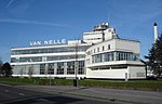 | NetherlandsRotterdam,
51°55′24″K 4°25′6″D / 51.92333°K 4.41833°D / 51.92333; 4.41833 (Van Nellefabriek) | Cultural:NetRot
(ii), (iv) | 694 (1.710) | 2014 | [89] |
| Spiennes'deki Neolitik Çakmaktaşı Madenleri |  | BelgiumSpiennes,
50°25′51″K 3°58′44″D / 50.43083°K 3.97889°D / 50.43083; 3.97889 (Neolithic Flint Mines at Spiennes (Mons)) | Cultural:BelSpi
(i), (iii), (iv) | 172 (430) | 2000 | [90] |
| New Lanark |  | United KingdomLanark, Scotland,
55°39′48″K 3°46′59″B / 55.66333°K 3.78306°B / 55.66333; -3.78306 (New Lanark) | Cultural:UniLanSco
(ii), (iv), (vi) | 146 (360) | 2001 | [91] |
| Nord-Pas-de-Calais Madencilik Havzası |  | FranceNord-Pas de Calais,
50°27′45″K 3°32′46″D / 50.46250°K 3.54611°D / 50.46250; 3.54611 (Nord-Pas de Calais Mining Basin) | Cultural:FraNor
(ii), (iv), (vi) | 3.943 (9.740) | 2012 | |
| Tournai'deki Notre-Dame Katedrali |  | BelgiumTournai,
50°36′22″K 3°23′21″D / 50.60611°K 3.38917°D / 50.60611; 3.38917 (Notre-Dame Cathedral in Tournai) | Cultural:BelTou
(ii), (iv) | 05 (12) | 2000 | [92] |
| Tarihi Bern Şehri |  | SwitzerlandBern,
46°56′53″K 7°27′1″D / 46.94806°K 7.45028°D / 46.94806; 7.45028 (Old City of Bern) | Cultural:SwiCanBer
(iii) | 84.684 (209.260) | 1983 | [93] |
| Eski ve Yeni Edinburgh Şehirleri |  | United KingdomEdinburgh, Scotland,
55°57′0″K 3°13′0″B / 55.95000°K 3.21667°B / 55.95000; -3.21667 (Old and New Towns of Edinburgh) | Cultural:UniEdiSco
(ii), (iv) | — | 1995 | [94] |
| Tarihi Regensburg Şehri ve Stadtamhof Mahallesi |  | GermanyRegensburg,
49°1′14″K 12°5′57″D / 49.02056°K 12.09917°D / 49.02056; 12.09917 (Old Town of Regensburg with Stadtamhof) | Cultural:GerBavReg
(ii), (iii), (iv) | 183 (450) | 2006 | [95] |
| Schönbrunn Sarayı ve Bahçesi |  | AustriaViyana,
48°11′12″K 16°18′48″D / 48.18667°K 16.31333°D / 48.18667; 16.31333 (Palace and Gardens of Schönbrunn) | Cultural:AusVie
(i), (iv) | 186 (460) | 1996 | [96] |
| Fontainebleau Sarayı ve Bahçesi |  | FranceFontainebleau,
48°24′7″K 2°41′53″D / 48.40194°K 2.69806°D / 48.40194; 2.69806 (Palace and Park of Fontainebleau) | Cultural:FraFon
(ii), (vi) | 144 (360) | 1981 | [97] |
| Versay Sarayı ve Bahçesi |  | FranceVersailles,
48°48′18″K 2°7′10″D / 48.80500°K 2.11944°D / 48.80500; 2.11944 (Palace and Park of Versailles) | Cultural:FraVer
(i), (ii), (vi) | 1.070 (2.600) | 1979 | [98] |
| Postdam ve Berlin'deki Bahçe ve Saraylar |  | GermanyBerlin, Potsdam,
52°23′59″K 13°1′59″D / 52.39972°K 13.03306°D / 52.39972; 13.03306 (Palaces and Parks of Potsdam and Berlin) | Cultural:GerBer4
(i), (ii), (iv) | 2.064 (5.100) | 1990 | [99] |
| Paris: Sen Nehri'nin Çevresi |  | FranceParis,
48°51′30″K 2°17′39″D / 48.85833°K 2.29417°D / 48.85833; 2.29417 (Paris, Banks of the Seine) | Cultural:FraPar
(i), (ii), (iv) | 365 (900) | 1991 | [100] |
| Wies Hac Kilisesi |  | GermanySteingaden,
47°40′53″K 10°54′1″D / 47.68139°K 10.90028°D / 47.68139; 10.90028 (Pilgrimage Church of Wies) | Cultural:GerSte
(i), (iii) | 01 (2,5) | 1983 | [101] |
| Nancy'deki Stanislas, Carrière ve Alliance Meydanları |  | FranceNancy,
48°41′37″K 6°10′59″D / 48.69361°K 6.18306°D / 48.69361; 6.18306 (Place Stanislas, Place de la Carrière and Place d'Alliance in Nancy) | Cultural:FraNan
(i), (iv) | 7 (17) | 1983 | [102] |
| Plantin-Moretus Müze Kompleksi |  | BelgiumAnvers,
51°13′6″K 4°23′52″D / 51.21833°K 4.39778°D / 51.21833; 4.39778 (Plantin-Moretus House-Workshops-Museum Complex) | Cultural:BelAnt
(ii), (iii),
(iv), (vi) | 023 (57) | 2005 | [103] |
| Pontcysyllte Su Kemeri ve Kanalları | 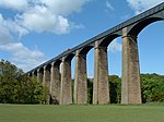 | United KingdomWrexham, Galler,
52°58′13″K 3°5′16″B / 52.97028°K 3.08778°B / 52.97028; -3.08778 (Pontcysyllte Aqueduct and Canal) | Cultural:UniWreWal
(i), (ii), (iv) | 105 (260) | 2009 | [104] |
| Pont du Gard (Roma Su Kemeri) |  | FranceVers-Pont-du-Gard,
43°56′50″K 4°32′7″D / 43.94722°K 4.53528°D / 43.94722; 4.53528 (Pont du Gard (Roman Aqueduct)) | Cultural:FraVer
(i), (iii), (iv) | 033 (82) | 1985 | [105] |
| Alplerin çevresinde yer alan Tarihöncesi Kazık Evler |  | Austria*,
*,
*,
*,
 *, *,
*
47°16′42″K 8°12′27″D / 47.27833°K 8.20750°D / 47.27833; 8.20750 (Prehistoric pile dwellings around the Alps) | Cultural:Swi
(iv), (v) | 3.961 (9.790) | 2011 | [106] |
| Vézère Vadisi'ndeki Tarihöncesi Alanlar ve Dekore Edilmiş Mağaralar |  | FranceLascaux,
45°3′27″K 1°10′12″D / 45.05750°K 1.17000°D / 45.05750; 1.17000 (Prehistoric Sites and Decorated Caves of the Vézère Valley) | Cultural:FraLas
(i), (iii) | — | 1979 | [107] |
| Karpatlardaki ve Avrupa'nın Diğer Bölgelerindeki İlkel Kayın Ormanları |  | Germany*,
 *, *,
 * *
49°5′10″K 22°32′10″D / 49.08611°K 22.53611°D / 49.08611; 22.53611 (Primeval Beech Forests of the Carpathians and the Ancient Beech Forests of Germany) | Natural:Ger1
(ix) | 33.670 (83.200) | 2007 | [108] |
| Provins: Orta Çağ Fuar Kenti |  | FranceProvins,
48°33′35″K 3°17′56″D / 48.55972°K 3.29889°D / 48.55972; 3.29889 (Provins, Town of Medieval Fairs) | Cultural:FraPro
(ii), (iv) | 108 (270) | 2001 | [109] |
| Pireneler-Mont Perdu |  | FranceHautes-Pyrénées and
Province of Huesca,
*
 * *
42°41′8″K 0°0′2″D / 42.68556°K 0.00056°D / 42.68556; 0.00056 (Pyrénées - Mont Perdu) | Mixed:FraHau
(iii), (iv), (v),
(vii), (viii) | 30.639 (75.710) | 1997 | [110] |
| Albula/Bernina Peyzajlarındaki Rhaetian Demiryolları |  | SwitzerlandGraubünden and Tirano,
*
*
46°29′54″K 9°50′47″D / 46.49833°K 9.84639°D / 46.49833; 9.84639 (Rhaetian Railway) | Cultural:SwiGra
(ii) (iv) | 109.386 (270.300) | 2008 | [111] |
| Rietveld Schröder Sarayı |  | NetherlandsUtrecht,
52°5′7″K 5°8′50″D / 52.08528°K 5.14722°D / 52.08528; 5.14722 (Rietveld Schröder House) | Cultural:NetUtr
(i), (ii) | — | 2000 | [112] |
| Trier'deki Roma Kalıntıları, St. Peter Katedrali ve Meryem Ana Kilisesi |  | GermanyTrier,
49°45′0″K 6°37′59″D / 49.75000°K 6.63306°D / 49.75000; 6.63306 (Roman Monuments, Cathedral of St. Peter and Church of Our Lady in Trier) | Cultural:GerTri
(i)(iii),
(iv), (vi) | — | 1986 | [113] |
| Orange'daki Roma Tiyatrosu ve çevresindeki anıtlar ile Zafer Takı |  | FranceOrange,
44°8′9″K 4°48′30″D / 44.13583°K 4.80833°D / 44.13583; 4.80833 (Roman Theatre and its Surroundings and the "Triumphal Arch" of Orange) | Cultural:FraOra
(iii), (vi) | 945 (2.340) | 1981 | [114] |
| Fransa'daki Santiago de Compostela Yolu |  | France
45°11′3″K 0°43′23″D / 45.18417°K 0.72306°D / 45.18417; 0.72306 (Routes of Santiago de Compostela in France) | Cultural:Fra2
(ii), (iv), (vi) | — | 1998 | [115] |
| Kraliyet Botanik Bahçeleri, Kew |  | United KingdomLondra, İngiltere,
51°28′55″K 0°17′39″D / 51.48194°K 0.29417°D / 51.48194; 0.29417 (Royal Botanic Gardens, Kew) | Cultural:UniLon2
(ii), (iii), (iv) | 132 (330) | 2003 | [116] |
| Salins-les-Bains'teki Büyük Tuz Fabrikası ve Arc-et-Senans'taki Kraliyet Tuz Fabrikası |  | FranceArc-et-Senans,
Salins-les-Bains,
46°56′15″K 5°52′35″D / 46.93750°K 5.87639°D / 46.93750; 5.87639 (Royal Saltworks of Arc-et-Senans) | Cultural:FraArc
(i), (ii), (iv) | 1.048 (2.590) | 1982 | [117] |
| Saltaire |  | United KingdomCity of Bradford, İngiltere,
53°50′21″K 1°47′18″B / 53.83917°K 1.78833°B / 53.83917; -1.78833 (Saltaire) | Cultural:United Kingdom
(ii), (iv) | 20 (49) | 2001 | [118] |
| Schokland ve Çevresi |  | NetherlandsNoordoostpolder,
52°38′19″K 5°46′18″D / 52.63861°K 5.77167°D / 52.63861; 5.77167 (Schokland and Surroundings) | Cultural:NetNoo
(iii), (v) | 1.306 (3.230) | 1995 | [119] |
| Semmering Demiryolu |  | AustriaGloggnitz,
Simmering in Styria,
47°38′56″K 15°49′41″D / 47.64889°K 15.82806°D / 47.64889; 15.82806 (Semmering railway) | Cultural:AusGlo
(ii), (iv) | 156 (390) | 1998 | [120] |
| Amsterdam'ın Singelgracht İçindeki Onyedinci Yüzyıl Yapımı Kanallar ile Çevrilmiş Bölgesi |  | NetherlandsAmsterdam,
52°21′54″K 4°53′16″D / 52.36500°K 4.88778°D / 52.36500; 4.88778 (Seventeenth-century canal ring area of Amsterdam inside the Singelgracht) | Cultural:NetAmsSev
(i), (ii), (iv) | 198 (490) | 2010 | [121] |
| Skellig Michael |  | IrelandCounty Kerry,
51°46′19″K 10°32′19″B / 51.77194°K 10.53861°B / 51.77194; -10.53861 (Skellig Michael) | Cultural:IreCou
(iii), (iv) | 22 (54) | 1996 | [122] |
| Speicherstadt ve Kontorhaus Şehirleri ve Chilehaus |  | GermanyHamburg,
53°32′36″K 9°59′31″D / 53.54333°K 9.99194°D / 53.54333; 9.99194 (Speicherstadt) | Cultural:GerSpei
(iv) | 26 (64) | 2015 | [123] |
| Speyer Katedrali | 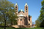 | GermanySpeyer,
49°19′0″K 8°26′35″D / 49.31667°K 8.44306°D / 49.31667; 8.44306 (Speyer Cathedral) | Cultural:GerSpey
(ii) | — | 1981 | [124] |
| St. Kilda |  | United KingdomSt Kilda, İskoçya,
57°49′2″K 8°34′36″B / 57.81722°K 8.57667°B / 57.81722; -8.57667 (St Kilda) | Mixed:UniStkSco
(iii), (v), (vii),
(ix), (x) | 24.201 (59.800) | 1986 | [125][126] |
| Hildesheim'deki Meryem Ana Katedrali ve St. Michael Kilisesi |  | GermanyHildesheim,
52°9′10″K 9°56′38″D / 52.15278°K 9.94389°D / 52.15278; 9.94389 (St Mary's Cathedral and St Michael's Church at Hildesheim) | Cultural:GerHil
(i), (ii), (iii) | 058 (140) | 1985 | [127] |
| Stoclet Sarayı |  | BelgiumBrüksel,
50°50′6″K 4°24′58″D / 50.83500°K 4.41611°D / 50.83500; 4.41611 (Stoclet House) | Cultural:BelBru3
(i), (ii) | 086 (210) | 2009 | [128] |
| Stonehenge, Avebury ve Bağlantılı Siteler |  | United KingdomWiltshire, İngiltere,
51°10′44″K 1°49′31″B / 51.17889°K 1.82528°B / 51.17889; -1.82528 (Stonehenge, Avebury and Associated Sites) | Cultural:UniWil
(i), (ii), (iii) | 4.985 (12.320) | 1986 | [129] |
| Strazburg–Grande Île | 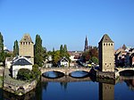 | FranceStrazburg,
48°34′53″K 7°43′48″D / 48.58139°K 7.73000°D / 48.58139; 7.73000 (Strasbourg – Grande île) | Cultural:FraStr
(i), (ii), (iv) | 94 (230) | 1988 | [130] |
| Fountains Manastırı Kalıntıları da Dahil Studley Kraliyet Parkı |  | United KingdomNorth Yorkshire, İngiltere,
54°6′58″K 1°34′23″B / 54.11611°K 1.57306°B / 54.11611; -1.57306 (Studley Royal Park including the Ruins of Fountains Abbey) | Cultural:UniNor
(i), (iv) | 309 (760) | 1986 | [131] |
| İsviçre Alpleri Jungfrau-Aletsch |  | SwitzerlandCantons of Bern ve Valais,
46°30′0″K 8°1′59″D / 46.50000°K 8.03306°D / 46.50000; 8.03306 (Swiss Alps Jungfrau-Aletsch) | Natural:SwiBer2
(vii), (viii), (ix) | 82.400 (204.000) | 2007 | [132] |
| Sardona Tektonik Bölgesi |  | SwitzerlandGlarus,
St. Gallen
and Graubünden,
46°55′0″K 9°15′0″D / 46.91667°K 9.25000°D / 46.91667; 9.25000 (Swiss Tectonic Arena Sardona) | Natural:SwiCanGla
(viii) | 32.850 (81.200) | 2008 | [133] |
| Bellinzona Pazar-Kentinin Üç Kalesi, Savunma Duvarları ve Siperleri |  | SwitzerlandBellinzona,
46°11′35″K 9°1′21″D / 46.19306°K 9.02250°D / 46.19306; 9.02250 (Three Castles of Bellinzona) | Cultural:SwiCanTic
(iv) | 5 (12) | 2000 | [134] |
| Londra Kalesi |  | United KingdomLondra, İngiltere,
51°30′29″K 0°4′34″B / 51.50806°K 0.07611°B / 51.50806; -0.07611 (Tower of London) | Cultural:UniLon3
(ii), (iv) | — | 1988 | [135] |
| Bremen Pazar Meydanı'ndaki Belediye Sarayı ve Roland Heykeli |  | GermanyBremen,
53°4′34″K 8°48′27″D / 53.07611°K 8.80750°D / 53.07611; 8.80750 (Town Hall and Roland on the Marketplace of Bremen) | Cultural:GerBre
(iii), (iv), (vi) | 029 (72) | 2004 | [136] |
| Tarihi Bamberg Şehri |  | GermanyBamberg,
49°53′30″K 10°53′20″D / 49.89167°K 10.88889°D / 49.89167; 10.88889 (Town of Bamberg) | Cultural:GerBam
(ii)(iv) | 142 (350) | 1993 | [137] |
| Yukarı Orta Ren Vadisi |  | GermanyRenanya-Palatina,
Hesse,
50°10′25″K 7°41′39″D / 50.17361°K 7.69417°D / 50.17361; 7.69417 (Upper Middle Rhine Valley) | Cultural:GerRhi
(ii), (iv), (v) | 27.250 (67.300) | 2002 | [138] |
| Vézelay, Kilise ve Tepe |  | FranceVézelay,
47°27′59″K 3°44′54″D / 47.46639°K 3.74833°D / 47.46639; 3.74833 (Vézelay, Church and Hill) | Cultural:FraVez
(i), (vi) | 183 (450) | 1979 | [139] |
| Völkingen Demir İşletmesi |  | GermanyVölklingen,
49°14′40″K 6°50′59″D / 49.24444°K 6.84972°D / 49.24444; 6.84972 (Völklingen Ironworks) | Cultural:GerVöl
(ii), (iv) | 6 (15) | 1994 | [140] |
| Wachau Vadisi’nin Kültürel Peyzajı |  | AustriaWachau,
48°21′52″K 15°26′3″D / 48.36444°K 15.43417°D / 48.36444; 15.43417 (Wachau Cultural Landscape) | Cultural:AusWac
(ii), (iv) | 18.387 (45.440) | 2000 | [141] |
| Wadden Denizi |  | Germany *, *,
*,
*
53°31′43″K 8°33′22″D / 53.52861°K 8.55611°D / 53.52861; 8.55611 (The Wadden Sea) | Natural:Ger2
(viii), (ix), (x) | 968.393 (2.392.950) | 2009, 2011, 2014 | [142] |
| Wartburg Kalesi |  | GermanyEisenach,
50°58′0″K 10°18′25″D / 50.96667°K 10.30694°D / 50.96667; 10.30694 (Wartburg Castle) | Cultural:GerEis
(iii), (vi) | — | 1999 | [143] |
| Westminster Sarayı, Westminster Manastırı ve St. Margaret Kilisesi | 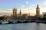 | United KingdomLondra, İngiltere,
51°29′59″K 0°7′43″B / 51.49972°K 0.12861°B / 51.49972; -0.12861 (Westminster Palace, Westminster Abbey and Saint Margaret's Church) | Cultural:UniLon4
(i), (ii), (iv) | 10 (25) | 1987 | [144][145][146] |
| Würzburg Rezidansı, Meydanı ve Bahçeleri |  | GermanyWürzburg,
49°47′34″K 9°56′20″D / 49.79278°K 9.93889°D / 49.79278; 9.93889 (Würzburg Residence with the Court Gardens and Residence Square) | Cultural:GerWür
(i), (iv) | 15 (37) | 1981 | [147] |
| Essen'deki Zollverein Kömür Madeni Endüstriyel Kompleksi |  | GermanyEssen,
51°29′29″K 7°2′46″D / 51.49139°K 7.04611°D / 51.49139; 7.04611 (Zollverein Coal Mine Industrial Complex in Essen) | Cultural:GerEss
(ii), (iii) | — | 2001 | [148] |

 French
 Deutsch


.jpg)


_North_views_of_the_Ste_C%C3%A9cile_Cathedral_and_the_Old_Bridge.jpg)


.JPG)


.jpg)


.jpg)


.jpg)


