
 French
 Deutsch
Dosya:Dependent territories.svg - Vikipedi

Bu SVG dosyasının PNG önizlemesinin boyutu: 800 × 406 piksel. Diğer çözünürlükler: 320 × 162 piksel | 640 × 325 piksel | 1.024 × 520 piksel | 1.280 × 650 piksel | 2.560 × 1.300 piksel | 2.754 × 1.398 piksel.
Tam çözünürlük (SVG dosyası, sözde 2.754 × 1.398 piksel, dosya boyutu: 1,05 MB)
Bu dosya Wikimedia Commons'ta bulunmaktadır. Dosyanın açıklaması aşağıda gösterilmiştir. Commons, serbest/özgür telifli medya dosyalarının bulundurulduğu depodur. Siz de yardım edebilirsiniz. |
Özet
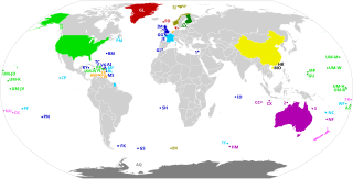
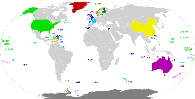
| Açıklama | English: Dependent territories and their sovereign countries. All territories are labelled according to ISO 3166-1. Each territory in the United States Minor Outlying Islands is labelled UM- followed by the first letter of its name and another unique letter if needed. The following territories do not have ISO 3166-1 codes: 1: Akrotiri and Dhekelia 2: Ashmore and Cartier Islands 3: Coral Sea Islands Español: Los Territorios dependientes en el Mundo y los países soberanos de los que dependen. Todos los territorios están etiquetados según la norma ISO 3166-1. Los siguientes territorios no tienen códigos ISO 3166-1: 1) Akrotiri y Dhekelia; 2) Islas Ashmore y Cartier; 3) Islas del Mar de CoralFrançais : Les territoires dépendants dans le monde et les pays souverains dont ils dépendent. Tous les territoires sont labellisés selon la norme ISO 3166-1. Les territoires suivants n'ont pas de codes ISO 3166-1 : 1) Akrotiri et Dhekelia ; 2) Iles Ashmore et Cartier ; 3) Iles de la mer de CorailPortuguês: Os territórios dependentes no mundo e os países soberanos dos quais eles dependem. Todos os territórios são rotulados de acordo com a norma ISO 3166-1. Os seguintes territórios não possuem códigos ISO 3166-1: 1) Akrotiri e Dhekelia; 2) Ashmore e Ilhas Cartier; 3) Ilhas do Mar de CorallDeutsch: Die abhängigen Gebiete in der Welt und die souveränen Länder, von denen sie abhängen. Alle Gebiete sind gemäß ISO 3166-1 gekennzeichnet. Die folgenden Gebiete haben keine ISO 3166-1-Codes: 1) Akrotiri und Dhekelia; 2) Ashmore- und Cartier-Inseln; 3) Korallenmeerinseln |
| Tarih | |
| Kaynak | Yükleyenin kendi çalışması, based on BlankMap-World.svg |
| Yazar | Heitordp |
Lisanslama
Ben, bu işin telif sahibi, burada işi aşağıdaki lisans altında yayımlıyorum:
| Bu dosya Creative Commons Evrensel Kamu Malı İthafı altındadır. | |
| Bu çalışmayı oluşturan kişi bu senet ile eser hakkında tüm dünya çapında telif hakkı yasaları kapsamında, yasalar tarafından izin verilen ölçülerde ve diğer benzer tüm haklarından feragat etmiş ve kamu malı olarak nitelendirmiştir. Siz bu çalışmayı ve eseri hiç bir izin almadan ticari amaçlar da dahil olmak üzere kopyalayabilir, değiştirebilir ve serbestçe dağıtabilirsiniz.
|
Dosya geçmişi
Dosyanın herhangi bir zamandaki hâli için ilgili tarih/saat kısmına tıklayın.
| Tarih/Saat | Küçük resim | Boyutlar | Kullanıcı | Yorum | |
|---|---|---|---|---|---|
| güncel | 22.56, 20 Temmuz 2020 | | 2.754 × 1.398 (1,05 MB) | M.Bitton | Added the missing border between Morocco and Western Sahara. |
| 20.58, 12 Temmuz 2020 |  | 2.754 × 1.398 (1,05 MB) | Heitordp | Corrected code of Heard Island and McDonald Islands, and removed color from Taiwan | |
| 12.13, 12 Temmuz 2020 |  | 2.754 × 1.398 (1,08 MB) | Wiz9999 | Replacing XAD, XAC, and XCS with 1,2, and 3 to make the map more neutral. XAD, XAC, and XCS do not represent any formal labelling/classification system to describe Akrotiri and Dhekelia, Ashmore and Cartier Islands, and Coral Sea Islands outside of this file. | |
| 22.05, 7 Temmuz 2020 |  | 2.754 × 1.398 (1,05 MB) | Heitordp | Uploaded own work with UploadWizard |
Dosya kullanımı
Bu görüntü dosyasına bağlantısı olan sayfalar:
Küresel dosya kullanımı
Aşağıdaki diğer vikiler bu dosyayı kullanır:
- arz.wikipedia.org üzerinde kullanımı
- bn.wikipedia.org üzerinde kullanımı
- en.wikipedia.org üzerinde kullanımı
- eu.wikipedia.org üzerinde kullanımı
- mk.wikipedia.org üzerinde kullanımı
- pt.wikipedia.org üzerinde kullanımı
- simple.wikipedia.org üzerinde kullanımı