
 French
 Deutsch
Dosya:Nangarhar districts.png - Vikipedi
Bu önizlemenin boyutu: 786 × 600 piksel. Diğer çözünürlükler: 315 × 240 piksel | 629 × 480 piksel | 1.000 × 763 piksel.
Tam çözünürlük ((1.000 × 763 piksel, dosya boyutu: 43 KB, MIME tipi: image/png))
Bu dosya Wikimedia Commons'ta bulunmaktadır. Dosyanın açıklaması aşağıda gösterilmiştir. Commons, serbest/özgür telifli medya dosyalarının bulundurulduğu depodur. Siz de yardım edebilirsiniz. |
 | Bu galeride bulunan tüm resimler vektörel grafikler kullanılarak SVG dosyası şeklinde oluşturulmalıdır. Bunun çeşitli avantajları vardır; daha fazla bilgi için Commons:Temizleme medyası sayfasına bakın. Eğer bu resmin SVG formatına sahipseniz, lütfen yükleyin. Lütfen SVG dosyanızı yükledikten sonra, bu şablonu bu resimdeki {{vector version available|yeni resim ismi.svg}} şablonu ile değiştirin. |
Özet
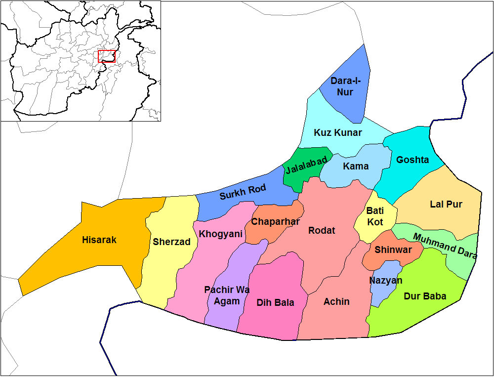
| Açıklama | English: Map of the districts of Nangarhar province of Afghanistan. Created by Rarelibra 19:29, 29 March 2007 (UTC) for public domain use, using MapInfo Professional v8.5 and various mapping resources. |
| Tarih | 29 Mart 2007 (original upload date) |
| Kaynak | No machine-readable source provided. Own work assumed (based on copyright claims). |
| Yazar | No machine-readable author provided. Rarelibra assumed (based on copyright claims). |
Lisanslama
| Ben, bu işin telif sahibi, bu işi kamu malı olarak yayınlıyorum. Bu dünya çapında geçerlidir. Bazı ülkelerde bu yasal olarak mümkün olmayabilir; öyleyse: Ben, bu işi herhangi bir amaç için, herhangi bir şart olmaksızın, yasalarca gerekli olmadıkça, herkesin kullanmasına izin veriyorum. |
Dosya geçmişi
Dosyanın herhangi bir zamandaki hâli için ilgili tarih/saat kısmına tıklayın.
| Tarih/Saat | Küçük resim | Boyutlar | Kullanıcı | Yorum | |
|---|---|---|---|---|---|
| güncel | 14.32, 15 Şubat 2024 | | 1.000 × 763 (43 KB) | User-duck | Cropped 5 % horizontally, 6 % vertically using CropTool with lossless mode. |
| 14.31, 15 Şubat 2024 |  | 1.056 × 816 (43 KB) | User-duck | Reverted to version as of 19:29, 29 March 2007 (UTC)recrop | |
| 19.11, 14 Şubat 2024 |  | 1.000 × 760 (43 KB) | User-duck | Cropped 5 % horizontally, 7 % vertically using CropTool with lossless mode. | |
| 19.29, 29 Mart 2007 |  | 1.056 × 816 (43 KB) | Rarelibra | Map of the districts of Nangarhar province of Afghanistan. Created by ~~~~ for public domain use, using MapInfo Professional v8.5 and various mapping resources. |
Dosya kullanımı
Bu görüntü dosyasına bağlantısı olan sayfalar:
Küresel dosya kullanımı
Aşağıdaki diğer vikiler bu dosyayı kullanır:
- ar.wikipedia.org üzerinde kullanımı
- bn.wikipedia.org üzerinde kullanımı
- ca.wikipedia.org üzerinde kullanımı
- cs.wikipedia.org üzerinde kullanımı
- de.wikipedia.org üzerinde kullanımı
- en.wikipedia.org üzerinde kullanımı
- Nangarhar Province
- Districts of Afghanistan
- Haji Ghalib
- Achin District
- Bati Kot District
- Chaparhar District
- Darai Nur District
- Dur Baba District
- Goshta District
- Hesarak District
- Kama District
- Khogyani District
- Kuz Kunar District
- Lal Pur District
- Momand Dara District
- Nazyan District
- Pachir Aw Agam District
- Rodat District
- Sherzad District
- Shinwar District
- User talk:Rarelibra/Maps1
- Haska Meyna District
- Khogyani (Pashtun tribe)
- Kot District
- Haska Meyna
Bu dosyanın daha fazla küresel kullanımını görüntüle.