
 French
 Deutsch
Dosya:Theoretical map of Romanian origins.png - Vikipedi

Bu önizlemenin boyutu: 776 × 600 piksel. Diğer çözünürlükler: 311 × 240 piksel | 621 × 480 piksel | 972 × 751 piksel.
Tam çözünürlük ((972 × 751 piksel, dosya boyutu: 705 KB, MIME tipi: image/png))
Bu dosya Wikimedia Commons'ta bulunmaktadır. Dosyanın açıklaması aşağıda gösterilmiştir. Commons, serbest/özgür telifli medya dosyalarının bulundurulduğu depodur. Siz de yardım edebilirsiniz. |
Özet
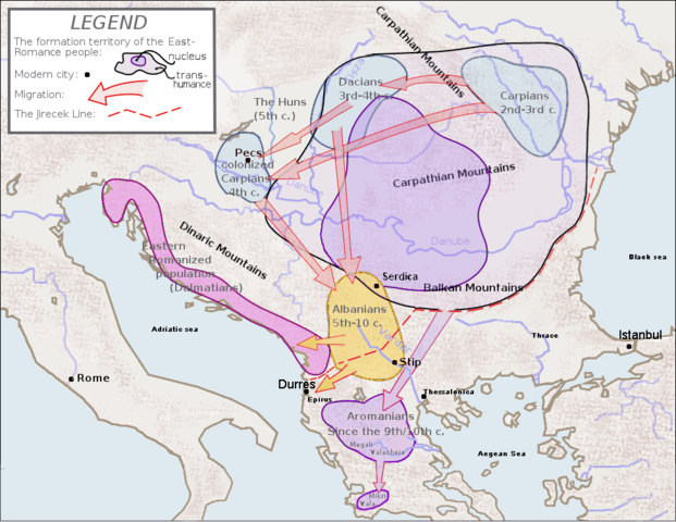
| Açıklama | English: Map of the general areas of the ethnogenesis of the Romanian & Albanian peoples since the linguistic hypothesis of the Daco-Thracian origin of the Albanian language (the other hypothesis supposes an Illyrian origin). Data from: Carlos Quiles, A Grammar of Modern Indo-European, ISBN 8461176391, page 76, fig. 47, and Asterios Koukoudis, The Vlachs : Metropolis and Diaspora, éd. Zitros, Thessaloniki 2003, ISBN: 9789607760869 according with Theophanos Confessor, Georgios Cedrenos and Apokaukos. I slightly fixed the shape of Italy. Image remains in public domain. GhePeU 22:08, 12 February 2006 (UTC) | ||
| Tarih | |||
| Kaynak | Yükleyenin kendi çalışması | ||
| Yazar | User:Ryanaxp | ||
| İzin (Bu dosyanın tekrar kullanımı) |
| ||
| Diğer sürümler |  |
Dosya geçmişi
Dosyanın herhangi bir zamandaki hâli için ilgili tarih/saat kısmına tıklayın.
| Tarih/Saat | Küçük resim | Boyutlar | Kullanıcı | Yorum | |
|---|---|---|---|---|---|
| güncel | 07.27, 15 Şubat 2021 | | 972 × 751 (705 KB) | Demetrios1993 | Extended the Jirecek line above Durres, like it was before. It was obviously taken out by mistake when Megistias replaced "Epidamnus" with "Durres". |
| 10.30, 20 Temmuz 2018 |  | 972 × 751 (602 KB) | Trecătorul răcit | Add Megali & Mikri Valacheia (Μεγάλη, Μικρή Βλαχία) since Theophanos Confessor, Georgios Cedrenos and Apokaukos according with Asterios Koukoudis, ''The Vlachs : Metropolis and Diaspora'', éd. Zitros, Thessaloniki 2003, ISBN: 9789607760869. | |
| 10.27, 25 Ekim 2015 |  | 972 × 675 (562 KB) | Spiridon Ion Cepleanu | Little cosmetic changes again (colours, shoreline) | |
| 15.58, 26 Nisan 2015 |  | 972 × 675 (567 KB) | Spiridon Ion Cepleanu | Little cosmetic changes (arrows, areas) | |
| 17.16, 20 Mart 2013 |  | 972 × 675 (564 KB) | Spiridon Ion Cepleanu | Little changes since Mircea Cociu : Spațiul etnic românesc, ed. Militară, Bucharest 1993, ISBN 973-32-0367-X, containing maps since Jireček, Petrović, Popp, Pușcariu & Rosetti | |
| 14.32, 15 Şubat 2010 |  | 972 × 675 (573 KB) | Megistias | Modern city name for Istanbul and Durres | |
| 22.42, 15 Eylül 2009 |  | 972 × 675 (573 KB) | Megistias | Minor tweak(aesthetic in image edge) | |
| 13.59, 2 Ocak 2008 |  | 972 × 675 (572 KB) | Megistias | This is a map of the general areas in which ethnogenesis of the Romanian people is believed to have occured. It was drawn by me, User:Ryanaxp, on July 31, 2005, and is hereby released into the public domain.{{pd-self}} I slightly fixed the shape of | |
| 22.06, 12 Şubat 2006 |  | 972 × 675 (574 KB) | GhePeU | ||
| 04.19, 31 Temmuz 2005 |  | 972 × 675 (689 KB) | Ryanaxp | This is a map of the general areas in which ethnogenesis of the Romanian people is believed to have occured. It was drawn by me, User:Ryanaxp, on July 31, 2005, and is hereby released into the public domain. {{pd}} |
Dosya kullanımı
Bu görüntü dosyasına bağlantısı olan sayfalar:
Küresel dosya kullanımı
Aşağıdaki diğer vikiler bu dosyayı kullanır:
- af.wikipedia.org üzerinde kullanımı
- ast.wikipedia.org üzerinde kullanımı
- ba.wikipedia.org üzerinde kullanımı
- bg.wikipedia.org üzerinde kullanımı
- ca.wikipedia.org üzerinde kullanımı
- ce.wikipedia.org üzerinde kullanımı
- cs.wikipedia.org üzerinde kullanımı
- cv.wikipedia.org üzerinde kullanımı
- de.wikipedia.org üzerinde kullanımı
- en.wikipedia.org üzerinde kullanımı
- eo.wikipedia.org üzerinde kullanımı
- es.wikipedia.org üzerinde kullanımı
- fr.wikipedia.org üzerinde kullanımı
- gl.wikipedia.org üzerinde kullanımı
- he.wikipedia.org üzerinde kullanımı
- hr.wikipedia.org üzerinde kullanımı
- id.wikipedia.org üzerinde kullanımı
- it.wikipedia.org üzerinde kullanımı
- ja.wikipedia.org üzerinde kullanımı
- ka.wikipedia.org üzerinde kullanımı
- ko.wikipedia.org üzerinde kullanımı
- lt.wikipedia.org üzerinde kullanımı
- nl.wikipedia.org üzerinde kullanımı
- pl.wikipedia.org üzerinde kullanımı
- pt.wikipedia.org üzerinde kullanımı
- ro.wikipedia.org üzerinde kullanımı
- ru.wikipedia.org üzerinde kullanımı
Bu dosyanın daha fazla küresel kullanımını görüntüle.