地狱峡谷 - 维基百科,自由的百科全书
此條目需要擴充。 (2018年3月21日) |
| 地狱峡谷 | |
|---|---|
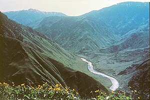
 斯内克河蜿蜒在峡谷内 | |
| 國家 | United States |
| 州 | 俄勒冈州、爱达荷州 |
| 县 | 瓦洛瓦縣、亞當斯縣、愛達荷縣 |
| 流域 | |
| 源頭 | 斯内克河 |
| • 位置 | Wallowa and Adams countiesWallowa and Idaho countiesnear river mile (RM) 254 |
| • 坐标 | 45°09′37″N 116°43′29″W / 45.16028°N 116.72472°W[2] |
| • 海拔 | 1,688英尺(515米)[1] |
| 河口 | 斯内克河 |
| • 位置 | Wallowa and Idaho countiesnear RM 238 |
| • 坐标 | 45°22′17″N 116°38′18″W / 45.37139°N 116.63833°W |
| • 海拔 | 1,384英尺(422米)[2] |
| 本貌 | |
| 流量 | |
| • 最小流量 | 1 cu ft/s(0.028 m3/s) |
地狱峡谷(英語:Hells Canyon)是条10英里(16公里)宽的峡谷,位于美国东俄勒冈州、东华盛顿州和西爱达荷州。它是地狱峡谷休闲区的一部分,也是北美洲最深的河谷[3],在斯内克河的冲刷下其峡谷深达7,993英尺(2,436米)。[4]
华工浴血滩
[编辑]1887年地狱峡谷华人大屠杀发生于地狱峡谷内的Dug Bar附近。2005年,美国地名委员会把这个屠杀地点正式命名为华工浴血滩 [5]。2012年6月22,美国哈佛学者、前美联社大记者R. Gregory Nokes [6]多方集资,制作了一个纪念碑,矗立于华工浴血滩 [7] [8]。这块石碑上面刻著三种语言,悼念遇难华工:英文、Sahaptin、与中文。
“一八八七年 三十多名金礦華工 在此慘遭殺戳 至今無人入罪” [9]
- 华工浴血滩纪念碑
参考资料
[编辑]- ^ Source elevation derived from Google Earth search using GNIS source coordinates.
- ^ 2.0 2.1 Hells Canyon. Geographic Names Information System. United States Geological Survey. 1979-06-21 [2010-12-26]. (原始内容存档于2021-11-05).
- ^ Hells Canyon National Recreation Area: Hells Canyon Overview. U.S. Forest Service. [2010-12-26]. (原始内容存档于2010-12-06).
- ^ Hells Canyon National Recreation Area: Establishment of HCNRA. U.S. Forest Service. [2010-12-26]. (原始内容存档于2010-12-03).
- ^ Board votes to name site after 1887 massacre. The Daily News Online (Associated Press). Jun 27, 2005 [2021-05-02]. (原始内容存档于2021-05-03).
- ^ Nokes, R. Gregory. Massacred for Gold, The Chinese in Hells Canyon. Oregon State University Press. October 2009: 208 [2021-05-02]. ISBN 978-0-87071-570-9. (原始内容存档于2021-05-02).
- ^ 另一个值得在五月底缅怀的日子:华工纪念日. 北美新视界. 美国华人联合会. 2020-05-27 [2021-05-02]. (原始内容存档于2021-05-05).
- ^ 先人的足迹3. 华工浴血滩. 珍珠湾全球网. 2018-03-25 [2021-05-02]. (原始内容存档于2021-05-02).
- ^ Chinese Massacre Cove. The Historical Marker Database. August 27, 2019 [2021-05-02]. (原始内容存档于2021-05-03).


 French
 Deutsch