白沙导弹靶场 - 维基百科,自由的百科全书
白沙导弹靶场[1] New Mexico Joint Guided Missile Test Range (1947) White Sands Proving Ground (1945) Alamogordo Bombing and Gunnery Range (1941)[2] | |
|---|---|
| 美國陸軍測試與評估司令部的一部分 | |
圣安德烈斯山脉 Oscura Mountains San Augustin Mountains Tularosa Basin Chupadera Mesa | |
 | |
 WSMR位置 | |
| 坐标 | 32°20′08″N 106°24′21″W / 32.33556°N 106.40583°W[3]Condron Army Airfield near the southernmost WSMR point |
| 设施信息 | |
| 控制者 | 美國陸軍 |
| 网站 | www |
| 历史 | |
| 建於 | 1948-07-09 cantonment completed[4] 1957-02: Launch Complex 37 completed |
| 建造者 | 军械兵团[4] |
| 驻军状态 | |
| 现任指挥官 | BG David C. Trybula(2019–現在)[5] |
| 历任指挥官 |
|
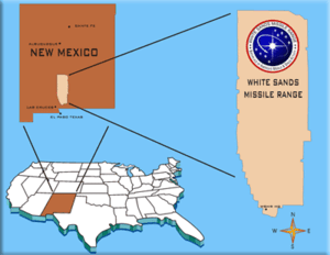
白沙导弹靶场(英語:White Sands Missile Range)位于美國新墨西哥州阿拉莫戈多,该导弹靶场由美国陆军所管理,面积大约8,287平方公里,为美国最大军事设施。它被称作美国陆军导弹的摇篮。[7]
歷史地標
[编辑]参考文献
[编辑]- ^ 存档副本. [2020-08-02]. (原始内容存档于2009-02-04).
- ^ Chapter Four: Global War at White Sands 1940–1945. White Sands Administrative History. National Park Service. [7 October 2008]. (原始内容存档于2010-11-11).
Executive Order No. 9029
- ^ Condron Army Airfield (2444053). Geographic Names Information System. United States Geological Survey. [2014-05-28]. (Doña Ana county—entered in the GNIS on 20 March 2011)
- ^ 4.0 4.1 Development of the Corporal: the embryo of the army missile program (PDF). Army Ballistic Missile Agency. April 1961. (原始内容 (PDF)存档于27 March 2009).
|volume=被忽略 (帮助) - ^ WSMR Official Website: Commanding Commander White Sands Missile Range. [2020-08-02]. (原始内容存档于2021-03-23).
- ^ OACSIM - Leadership - ACSIM. www.acsim.army.mil. [2020-08-02]. (原始内容存档于2020-06-15).
- ^ 揭秘美国四大新武器试验场:先进装备的最后门槛. [2008-04-29]. (原始内容存档于2008-05-09).
| 这是一篇美國軍事小作品。您可以通过编辑或修订扩充其内容。 |


 French
 Deutsch