蓋恩斯敦 (阿拉巴馬州) - 维基百科,自由的百科全书
| 蓋恩斯敦 | |
|---|---|
| 非建制地區 | |
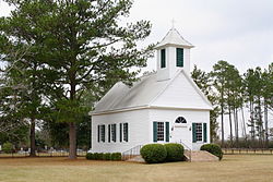
 蓋恩斯敦的循道宗教堂 | |
| 坐标:31°26′43.58″N 87°41′36″W / 31.4454389°N 87.69333°W | |
| 國家 | 美国 |
| 州份 | 阿拉巴馬州 |
| 縣 | 克拉克縣 |
| 海拔 | 81 公尺(266 英尺) |
| 时区 | 北美中部时区(UTC-6) |
| • 夏时制 | CDT(UTC-5) |
| 電話區號 | 251 |
| 地名信息系统ID | 156387[1] |
蓋恩斯敦(英語:Gainestown)是一個位於美國阿拉巴馬州克拉克縣的非建制地區,位於阿拉巴馬河畔。該地的面積和人口皆未知[2]。蓋恩斯敦得名自喬治·斯特羅·蓋恩斯,他於1809年在此地建立了一處與美洲原住民貿易的貿易站[3],1814年克里克战争結束後貿易站也告關閉。蓋恩斯敦城鎮明確的建立年代已不可考,不過最早在1815年已有人以此名稱呼這裡的社區。在河運貿易興盛的年代,蓋恩斯敦曾增長為一個大型城鎮,但南北戰爭後又慢慢地衰退[4]。 1911年3月26日,蓋恩斯敦被龍捲風侵襲,至少有12間房子被毀[4],主要街區也受到相當破壞。當時的記載指出鎮上一間乾貨店被毀,店內的貨物碎片被吹到遠處,在東邊30英里(48公里)外的門羅縣被發現[5]。
蓋恩斯敦有三個遺址名列國家史蹟名錄,分別是蓋恩斯敦循道宗教堂與墓園、蓋恩斯敦校舍與威爾森-芬利之家[6]。
地理
[编辑]蓋恩斯敦的座標為31°26′44″N 87°41′36″W / 31.44544°N 87.69332°W[1],而該地最高點為海拔高度81米(即266英尺)。
參考文獻
[编辑]- ^ 1.0 1.1 xxx. Geographic Names Information System. United States Geological Survey.
- ^ American FactFinder. 美国人口调查局. [2011-05-14]. (原始内容存档于2013-09-11).
- ^ Historical Markers & Sites in Clarke County. Clarke County Historical Society. [February 21, 2011]. (原始内容存档于2010-11-20).
- ^ 4.0 4.1 Clarke County MPS (PDF). National Register of Historic Places. National Park Service. [February 21, 2011]. (原始内容存档 (PDF)于2016-10-11).
- ^ United States Army Signal Corps; et al. District No. 2: South Atlantic and East Gulf States. Monthly Weather Review (War Department, Office of the Chief Signal Officer). 1911, 39 (1): 332. doi:10.1175/1520-0493(1911)39<331:dnsaae>2.0.co;2.
- ^ National Register Information System. National Register of Historic Places. National Park Service. 2009-03-13.


 French
 Deutsch
