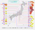
File:2011 Tohoku earthquake observed tsunami heights.png - 维基百科,自由的百科全书

本预览的尺寸:656 × 600像素。 其他分辨率:263 × 240像素 | 525 × 480像素 | 700 × 640像素。
原始文件 (700 × 640像素,文件大小:299 KB,MIME类型:image/png)
文件历史
点击某个日期/时间查看对应时刻的文件。
| 日期/时间 | 缩略图 | 大小 | 用户 | 备注 | |
|---|---|---|---|---|---|
| 当前 | 2011年4月29日 (五) 10:47 |  | 700 × 640(299 KB) | Pekachu | 相馬の津波高さ変更に伴う修正([http://www.jma.go.jp/jma/press/1104/13a/201104131600.html JMA press]) |
| 2011年4月2日 (六) 13:38 |  | 700 × 640(299 KB) | Pekachu | 着色間違いを訂正 | |
| 2011年4月2日 (六) 13:22 |  | 700 × 640(299 KB) | Pekachu | {{Information |Description ={{en|1=Map of 2011 Tohoku(Sendai) earthquake observed tsunami heights in Japan.}} {{ja|1=東北地方太平洋沖地震で観測された、日本各地の |
文件用途
以下2个页面使用本文件:
全域文件用途
以下其他wiki使用此文件:
- en.wikipedia.org上的用途
- ja.wikipedia.org上的用途
- ko.wikipedia.org上的用途
- zh-yue.wikipedia.org上的用途


 French
 Deutsch
