File:Strait of Dover map.png - 维基百科,自由的百科全书

本预览的尺寸:798 × 599像素。 其他分辨率:320 × 240像素 | 639 × 480像素 | 1,000 × 751像素。
原始文件 (1,000 × 751像素,文件大小:187 KB,MIME类型:image/png)
文件历史
点击某个日期/时间查看对应时刻的文件。
| 日期/时间 | 缩略图 | 大小 | 用户 | 备注 | |
|---|---|---|---|---|---|
| 当前 | 2014年6月13日 (五) 19:17 |  | 1,000 × 751(187 KB) | Hohum | Adjust colours |
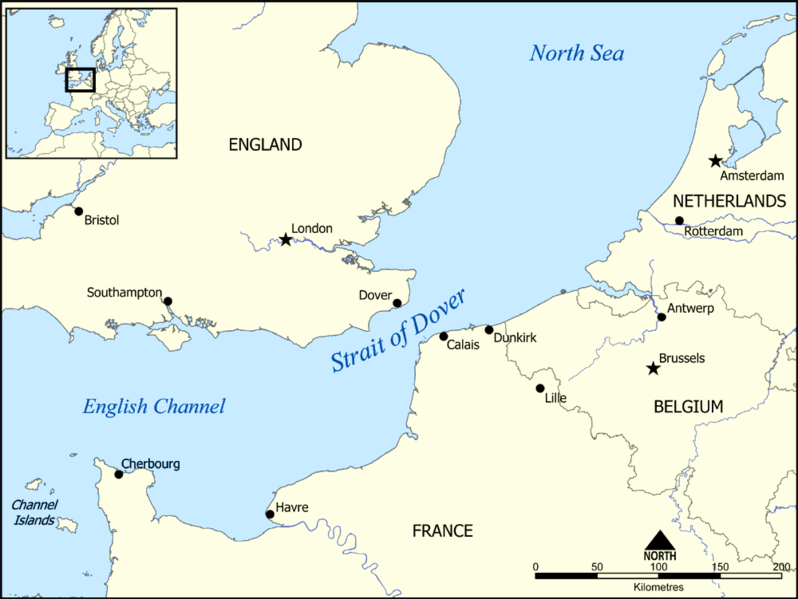
| 2005年12月15日 (四) 15:34 |  | 1,000 × 751(296 KB) | NormanEinstein | This map shows the location of the Strait of Dover between England and France, and part of the English Channel and the North Sea. It also shows nearby towns such as Dover, Calais, and Dunkirk. Created by NormanEinstein, December 15, 2005. {{GFDL-self}} |
文件用途
以下2个页面使用本文件:
全域文件用途
以下其他wiki使用此文件:
- af.wikipedia.org上的用途
- an.wikipedia.org上的用途
- ar.wikipedia.org上的用途
- ba.wikipedia.org上的用途
- be-tarask.wikipedia.org上的用途
- be.wikipedia.org上的用途
- bg.wikipedia.org上的用途
- bh.wikipedia.org上的用途
- bn.wikipedia.org上的用途
- br.wikipedia.org上的用途
- da.wikipedia.org上的用途
- de.wikipedia.org上的用途
- el.wikipedia.org上的用途
- en.wikipedia.org上的用途
- en.wikibooks.org上的用途
- fa.wikipedia.org上的用途
- fi.wikipedia.org上的用途
- fr.wikipedia.org上的用途
- fy.wikipedia.org上的用途
- gl.wikipedia.org上的用途
- hu.wikipedia.org上的用途
- id.wikipedia.org上的用途
- it.wikipedia.org上的用途
- ja.wikipedia.org上的用途
- la.wikipedia.org上的用途
- mr.wikipedia.org上的用途
- ms.wikipedia.org上的用途
- nn.wikipedia.org上的用途
- no.wikipedia.org上的用途
- pt.wikipedia.org上的用途
- ro.wikipedia.org上的用途
- simple.wikipedia.org上的用途
查看此文件的更多全域用途。


 French
 Deutsch


