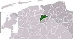
Grootegast
Grootegast | |
|---|---|
Village, former municipality | |
 Wind mill in Sebaldeburen | |
 Location in Groningen | |
| Coordinates: 53°13′N 6°17′E / 53.217°N 6.283°E | |
| Country | |
| Province | |
| Municipality | |
| Area | |
• Total | 31.27 km2 (12.07 sq mi) |
| Elevation | 2 m (7 ft) |
| Population (2021)[1] | |
• Total | 3,350 |
| • Density | 110/km2 (280/sq mi) |
| Time zone | UTC+1 (CET) |
| • Summer (DST) | UTC+2 (CEST) |
| Postcode | 9820–9823, 9860–9869 |
| Area code | 0594 |
Grootegast (Dutch pronunciation: [ˈɣroːtəˌɣɑst] ⓘ; Gronings: Grodegast; West Frisian: Gruttegast) is a village and former municipality in the northeastern Netherlands. It is the sister city of Kingston, Tasmania. The municipality was merged into the municipality of Westerkwartier on 1 January 2019.[3]
Geography
[edit]
The former municipality contained the population centres: Doezum, Enumatil, Faan, Grootegast, Kornhorn, Lutjegast, Niekerk, Oldekerk, Opende, Sebaldeburen. In some of these villages, they still speak the West Frisian language.
History
[edit]The village originated around the year 1000 (as Majorgast) and was profiled from 1400 onwards as the counterpart of Lutjegast. The village contains a 17th-century church, the so-called Witte Kerkje ('Little White Church'). This church was restored in 1829.[4]
Grootegast was the main village of the former municipality. The name of the village refers to a gast or gaast, a higher, sandy ridge in an otherwise swampy area. Groot is Dutch for 'large'.
Dialect
[edit]The Grootegasters dialect, or Westerkwartiers, is clearly a borderline case. Linguistically, the influences of three provinces are noticeable: the dialect is a variant of Gronings, but in terms of intelligibility it is more like Drents; however, the accent and grammar sound rather Frisian, which can be explained by the fact that almost all of Lutjegast still spoke Frisian 100 years ago. Being a border village of Lutjegast, Frisian influence is still noticeable today in the number of villagers of Frisian origin and the many business and social contacts with Friesland.
Notable people
[edit]- Cornelius Van Til (1895–1987), theologian
- Ron Groenewoud (1937), football player
References
[edit]- ^ a b "Kerncijfers wijken en buurten 2021". Central Bureau of Statistics. Retrieved 7 March 2022.
- ^ "Postcodetool for 9861AC". Actueel Hoogtebestand Nederland (in Dutch). Het Waterschapshuis. Archived from the original on 21 September 2013. Retrieved 21 January 2014.
- ^ "Gemeentelijke indeling op 1 januari 2019". CBS (in Dutch). Retrieved 30 November 2019.
- ^ Formsma, W.J.; Luitjens-Dijkveld, R.A.; Pathuis, A. (1987). De Ommelander Borgen en Steenhuizen. Round the World Publishing. ISBN 9023223144.
External links
[edit] Media related to Grootegast at Wikimedia Commons


 French
 Deutsch
