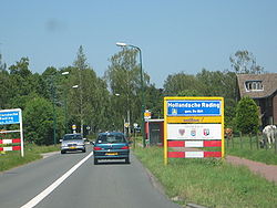
Hollandsche Rading
Hollandsche Rading | |
|---|---|
Village | |
 Entrance sign for Hollandsche Rading | |
| Coordinates: 52°10′30″N 5°10′45″E / 52.17500°N 5.17917°E | |
| Country | Netherlands |
| Province | Utrecht |
| Municipality | De Bilt |
| Area | |
| • Total | 8.33 km2 (3.22 sq mi) |
| Elevation | 2 m (7 ft) |
| Population (2021)[1] | |
| • Total | 1,575 |
| • Density | 190/km2 (490/sq mi) |
| Time zone | UTC+1 (CET) |
| • Summer (DST) | UTC+2 (CEST) |
| Postal code | 3739[1] |
| Dialing code | 035 |
Hollandsche Rading is a village in the Dutch province of Utrecht. It is a part of the municipality of De Bilt, and lies about 5 km south of Hilversum. Hollandsche Rading has a railway station on the route between Utrecht and Hilversum.
The name means "Border of Holland": the village is located on the border between the provinces Utrecht and North Holland.
History
[edit]It was first mentioned in 1696 as Die Hollantse Radinge, but had been the border since 1352.[3] The border is nowadays just to the north of the village. Up to 1930, Hollandsche Rading mainly consisted of heath.[4] Yet, in 1885, a railway station was constructed in the hamlet.[5] The houses were built for the people returning from the Dutch East Indies. In 1938, a church was built.[4]
Gallery
[edit]- Restaurant in Hollandsche Rading
- Railway station
- House in Hollandsche Rading
- House in Hollandsche Rading
References
[edit]- ^ a b c "Kerncijfers wijken en buurten 2021". Central Bureau of Statistics. Retrieved 28 March 2022.
two entries
- ^ "Postcodetool for 3739JG". Actueel Hoogtebestand Nederland (in Dutch). Het Waterschapshuis. Retrieved 28 March 2022.
- ^ "Hollandsche Rading - (geografische naam)". Etymologiebank (in Dutch). Retrieved 28 March 2022.
- ^ a b "Hollandsche Rading". Plaatsengids (in Dutch). Retrieved 28 March 2022.
- ^ "Station Hollandsche Rading". Stationsweb (in Dutch). Retrieved 28 March 2022.
Wikimedia Commons has media related to Hollandsche Rading.


 French
 Deutsch


