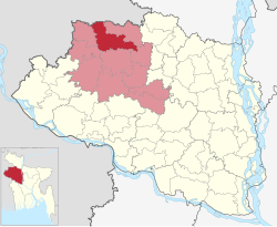
Patnitala Upazila
Patnitala Upazila পত্নীতলা উপজেলা | |
|---|---|
 | |
| Coordinates: 25°3′N 88°44′E / 25.050°N 88.733°E | |
| Country | |
| Division | Rajshahi |
| District | Naogaon |
| Area | |
• Total | 382.38 km2 (147.64 sq mi) |
| Population | |
• Total | 250,729 |
| • Density | 660/km2 (1,700/sq mi) |
| Time zone | UTC+6 (BST) |
| Postal code | 6540[2] |
| Website | patnitala |
Patnitala Upazila (Bengali: পত্নীতলা উপজেলা) is an Upazila of Naogaon District in the Division of Rajshahi, Bangladesh.
Geography
[edit]
Patnitala is located at 25°03′00″N 88°44′00″E / 25.0500°N 88.7333°E. It has 58,661 units of households and total area 382.38 km2. The major rivers are the Atrai and the Shiba.[3]
Patnitala Upazila is bounded by Dhamoirhat Upazila and Tapan CD Block of Dakshin Dinajpur district, West Bengal, India, on the north, Badalgachhi on the east, Mohadevpur Upazila on the south and Porsha and Sapahar Upazilas on the west.[3][4][5]
Demographics
[edit]According to the 2011 Census of Bangladesh, Patnitala Upazila had 58,661 households and a population of 231,900. 43,996 (18.97%) were under 10 years of age. Patnitala had a literacy rate (age 7 and over) of 52.55%, compared to the national average of 51.8%, and a sex ratio of 987 females per 1000 males. 21,670 (9.34%) lived in urban areas.[7] Ethnic population was 20,270 (8.74%), of which Oraon were 6,552, Santal 5,375 and Barman 3,780.[8]
As of the 1991 Bangladesh census, Patnitala had a population of 1 98 164. Males constituted 51.26% of the population and females 48.74%. This upazila's eighteen up population was 98279. Patnitala had an average literacy rate of 32.9% (7+ years), and the national average of 32.4% literate.[9]
Points of interest
[edit]Dibar Dighi is a large historic pond with a stone pillar, Kaivarta stambha, in its middle. Both date from the late eleventh century.[10][11][12][13]
- Gahon Pirbabar Mazar, Patnitala
- Kancon, Hazarat Zahor Uddin Cistia Babar Mazar, Patnitala
- Katabari Mazar, Patnitala
- Atrai River, Patnitala
- Nazipur Pouro Park, Nazipur
- Paikbanda Shalbon
- More than Forest (Shihara and Nirmoil)
Administration
[edit]Niamatpur Thana was formed in 1918 and it was turned into an upazila in 1983.[14]
Patnitala Upazila is divided into Patnitala Municipality and 11 union parishads: Akbarpur, Amair, Dibar, Goshnagar, Krishanapur, Matindhar, Nazipur, Nirmail, Patichara, Patnitala, and Shihara. The union parishads are subdivided into 297 mauzas and 297 villages.[15]
M P: Alhaz Shahidujjaman Sarker Bablu. Upazila Chairman: Md. Abdul Gaffar. Mayor of Nazipur Municipality: Rezaul Karim Babu (Balu Babu)
Education
[edit]There are four colleges in the upazila. They include Chowrat Shibpur Barendra College; Nazipur Government College, founded in 1973; and Nazipur Mohila College (1995).[3][16]
According to Banglapedia, Kantabari High School, founded in 1924, Nazipur Pilot High School (1930), and Sarlabala (Gandhi) Girls' School (1920), are notable secondary schools.[3]
The madrasa education system includes seven fazil madrasas. Nazipur Siddikia Fazil Madrasha was founded in 1969.[3][17]
See also
[edit]References
[edit]- ^ National Report (PDF). Population and Housing Census 2022. Vol. 1. Dhaka: Bangladesh Bureau of Statistics. November 2023. p. 402. ISBN 978-9844752016.
- ^ "Bangladesh Postal Code". Dhaka: Bangladesh Postal Department under the Department of Posts and Telecommunications of the Ministry of Posts, Telecommunications and Information Technology of the People's Republic of Bangladesh. 21 October 2024.
- ^ a b c d e Tuhin, Shamsul Arefin (2012). "Patnitala Upazila". In Islam, Sirajul; Jamal, Ahmed A. (eds.). Banglapedia: National Encyclopedia of Bangladesh (Second ed.). Asiatic Society of Bangladesh.
- ^ "District Census Handbook 2011 Dakshin Dinajpur" (PDF). Map of Dakshin Dinajpur showing CD Blocks on the fourth page. Directorate of Census Operations. Retrieved 8 December 2018.
- ^ "District Human Development Report" (PDF). Uttar Dinajpur. Page 14: Map showing locational setting of Uttar Dinajpur district (includes Dakshin Dinajpur district). Department of Planning, Statistics and Programme Implementation, Government of West Bengal. Archived from the original (PDF) on 24 December 2019. Retrieved 8 December 2018.
- ^ Population and Housing Census 2022 - District Report: Naogaon (PDF). District Series. Dhaka: Bangladesh Bureau of Statistics. June 2024. ISBN 978-984-475-233-7.
- ^ "Bangladesh Population and Housing Census 2011 Zila Report – Naogaon" (PDF). bbs.gov.bd. Bangladesh Bureau of Statistics.
- ^ "Community Tables: Naogaon district" (PDF). bbs.gov.bd. Bangladesh Bureau of Statistics. 2011.
- ^ "Population Census Wing, BBS". Archived from the original on 2005-03-27. Retrieved November 10, 2006.
- ^ Chakrabarti, Dilip K. (1992). Ancient Bangladesh, a study of the archaeologcial sources. Oxford University Press. p. 155.
- ^ Indian Information Series. Vol. 4–5. India: Bureau of Public Information. 1939.
- ^ Maitreẏa, Akshaẏakumāra (1987). The fall of the Pāla Empire. University of North Bengal. p. 44.
- ^ Rahman, Kazi Mostafizur (2012). "Dibar Dighi and Kaivarta Stambha". In Islam, Sirajul; Jamal, Ahmed A. (eds.). Banglapedia: National Encyclopedia of Bangladesh (Second ed.). Asiatic Society of Bangladesh.
- ^ "Niamatpur Upazila - Banglapedia". en.banglapedia.org. Retrieved 2023-02-23.
- ^ "District Statistics 2011: Naogaon" (PDF). Bangladesh Bureau of Statistics. Archived from the original (PDF) on 13 November 2014. Retrieved 14 July 2014.
- ^ "List of Colleges" (Excel). Bangladesh Bureau of Education Information and Statistics.
- ^ "Fazil Madrasha". Ministry of Education. Archived from the original on 2014-10-07. Retrieved 15 July 2014.


 French
 Deutsch