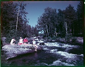
Rushing River Provincial Park
| Rushing River Provincial Park | |
|---|---|
 | |
Location of the park in Ontario | |
| Location | Kenora District, Ontario, Canada |
| Nearest city | Kenora |
| Coordinates | 49°41′22″N 94°13′40″W / 49.68944°N 94.22778°W[2] |
| Area | 340 ha (840 acres)[3] |
| Designation | Recreational |
| Established | 1958[4][3] |
| Visitors | 75,300 (in 2022[5]) |
| Governing body | Ontario Parks |
| www | |
 | |
Rushing River Provincial Park is 20 kilometres (12 mi) southeast of Kenora, Ontario, Canada.[2] It is a family campground at the mouth of the Rushing River where it enters Dogtooth Lake. It is a gateway to Eagle-Dogtooth Provincial Park, that borders on its east side.[3]
The park has predominantly glacial features. The Park features swimming, boating, canoe, kayak and stand up paddle board rentals, as well as fishing, hiking, and camping including electrical and non electrical sites.[3]
References
[edit]- ^ UNEP-WCMC. "Protected Area Profile for Rushing River Provincial Park". World Database on Protected Areas. Retrieved 2024-11-08.
- ^ a b "Eagle-Rushing River Provincial Park". Geographical Names Data Base. Natural Resources Canada. Retrieved 23 October 2023.
- ^ a b c d "Rushing River Provincial Park". www.ontarioparks.com. Ontario Parks. Retrieved 23 October 2023.
- ^ "Rushing River Provincial Park - Recreation". Protected Planet. Archived from the original on 3 September 2014.
- ^ Parks, Ontario. "Ontario_Parks-Visitation-Statistics 2022 - Ministries". data.ontario.ca. Retrieved 2024-11-08.
External links
[edit]


 French
 Deutsch
