Las Cruces, New Mexico - Simple English Wikipedia, the free encyclopedia
Las Cruces, New Mexico | |
|---|---|
| Nickname: The City of the Crosses | |
| Motto: People Helping People | |
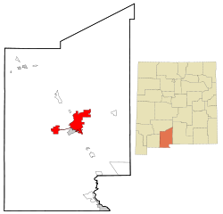
 Location of Las Cruces within Doña Ana County and New Mexico | |
| Coordinates: 32°18′52″N 106°46′44″W / 32.31444°N 106.77889°W | |
| Country | |
| State | |
| County | Doña Ana |
| Founded | 1849 |
| Incorporated | 1907[1]: 135 |
| Government | |
| • Type | Council–manager |
| Area | |
| • City | 77.03 sq mi (199.51 km2) |
| • Land | 76.93 sq mi (199.26 km2) |
| • Water | 0.10 sq mi (0.25 km2) |
| Elevation | 3,900 ft (1,200 m) |
| Population | |
| • City | 111,385 |
| • Density | 1,447.82/sq mi (559.00/km2) |
| • Metro | 217,552 (US: 202th) |
| Demonym | Las Crucen |
| Time zone | UTC−07:00 (Mountain) |
| • Summer (DST) | UTC−06:00 (DST) |
| ZIP Codes | 88001, 88003-88007, 88011-88013 |
| Area code | 575 |
| FIPS code | 35-39380 |
| GNIS feature ID | 0899715 |
| Website | www |
Las Cruces is the second largest city in the American state of New Mexico. The current population is about 110,000. The city is known for its large Urban Renewal Project that tore down much of its historic Main Street area.
The main campus of New Mexico State University is in Las Cruces.
References
[change | change source]- ↑ Harris, Linda G. (1993). Las Cruces: An Illustrated History. Las Cruces: Arroyo Press. ISBN 0-9623682-5-3.
- ↑ "ArcGIS REST Services Directory". United States Census Bureau. Retrieved October 12, 2022.
- ↑ "QuickFacts: Las Cruces city, New Mexico". United States Census Bureau. Retrieved March 14, 2024.


 French
 Deutsch


