Soest (district) - Simple English Wikipedia, the free encyclopedia
Soest | |
|---|---|
 | |
| Coordinates: 51°35′N 8°15′E / 51.58°N 8.25°E | |
| Country | Germany |
| State | North Rhine-Westphalia |
| Adm. region | Arnsberg |
| Capital | Soest |
| Area | |
| • Total | 1,327.47 km2 (512.54 sq mi) |
| Population (31 December 2023)[1] | |
| • Total | 306,674 |
| • Density | 230/km2 (600/sq mi) |
| Time zone | UTC+01:00 (CET) |
| • Summer (DST) | UTC+02:00 (CEST) |
| Vehicle registration | SO |
| Website | http://www.kreis-soest.de |
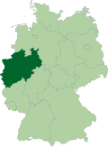
Soest (IPA: [ˈzoːst]) is a Kreis (district) in the middle of North Rhine-Westphalia, Germany.
Coat of arms
[change | change source] | The coat of arms show two symbols from the bishops Cologne, who owned the Soest until 1449. In left half is the key of Saint Peter, the patron of Cologne, in the right the black cross of Cologne. After the district was merged with Lippstadt the rose as symbol of the Lippe area was added on top of the cross. This new version of the coat of arms was granted in 1976. |
Towns and municipalities
[change | change source]| Towns | Municipalities |
|---|---|
References
[change | change source]Other websites
[change | change source]- Official website Archived 2012-05-03 at the Wayback Machine (German, English)


 French
 Deutsch
