
 French
 Deutsch
List of the highest major summits of Colorado

The following sortable table comprises the 117 highest mountain peaks of the U.S. State of Colorado with at least 3000 meters (9843 feet) of elevation and at least 500 meters (1640 feet) of topographic prominence.
Topographic elevation is the vertical distance above the reference geoid, a mathematical model of the Earth's sea level as an equipotential gravitational surface. The topographic prominence of a summit is the elevation difference between that summit and the highest or key col to a higher summit. The topographic isolation of a summit is the minimum great-circle distance to a point of equal elevation.
This article defines a significant summit as a summit with at least 100 meters (328.1 feet) of topographic prominence, and a major summit as a summit with at least 500 meters (1640 feet) of topographic prominence. An ultra-prominent summit is a summit with at least 1500 meters (4921 feet) of topographic prominence. There are three ultra-prominent summits in Colorado.
All elevations in this article include an elevation adjustment from the National Geodetic Vertical Datum of 1929 (NGVD 29) to the North American Vertical Datum of 1988 (NAVD 88). For further information, please see this United States National Geodetic Survey note.
If an elevation or prominence is calculated as a range of values, the arithmetic mean is shown.
Highest major summits
[edit]Gallery
[edit]-

-

-
 3. Mount Harvard is the highest of the Collegiate Peaks and the third-highest peak of the Rocky Mountains.
 -
 4. Blanca Peak is the highest peak of the Sangre de Cristo Mountains and the second-most topographically isolated peak of Colorado.
 -

-
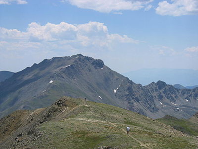
 6. Uncompahgre Peak is the highest peak of the San Juan Mountains and the sixth-highest peak of the Rocky Mountains.
 -
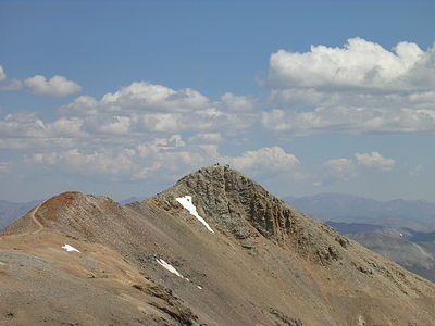
 7. Crestone Peak is the highest peak of the Crestones and the seventh-highest peak of the Rocky Mountains.
 -
 8. Mount Lincoln is the highest peak of the Mosquito Range and the eighth-highest peak of the Rocky Mountains.
 -
 9. Castle Peak is the highest peak of the Elk Mountains and the ninth-highest peak of the Rocky Mountains.
 -
 10. Grays Peak is the highest peak of the Front Range and the tenth-highest peak of the Rocky Mountains.
 -

-
 25. This photograph of the legendary Mount of the Holy Cross was taken by William Henry Jackson in 1874.


_-_2006-07-16.jpg)


See also
[edit]- List of mountain peaks of North America
- List of mountain peaks of Greenland
- List of mountain peaks of Canada
- List of mountain peaks of the Rocky Mountains
- List of mountain peaks of the United States
- List of mountain peaks of México
- List of mountain peaks of Central America
- List of mountain peaks of the Caribbean
- Colorado
- Physical geography
Notes
[edit]- ^ The summit of Mount Elbert is the highest point of the U.S. State of Colorado, the Rocky Mountains of North America, and the entire Mississippi River drainage basin.
- ^ Mount Massive is the second-highest summit of the Rocky Mountains.
- ^ The elevation of Mount Massive includes an adjustment of +2.087 m (6.85 ft) from NGVD 29 to NAVD 88.
- ^ The summit of Mount Harvard is the highest point of the Collegiate Peaks.
- ^ Mount Harvard is the southernmost and easternmost summit of its elevation in the Rocky Mountains.
- ^ The summit of Blanca Peak is the highest point of the Sangre de Cristo Mountains and the entire Rio Grande drainage basin.
- ^ Blanca Peak is the southernmost ultra-prominent summit of the Rocky Mountains.
- ^ The elevation of Blanca Peak includes an adjustment of +1.755 m (5.76 ft) from NGVD 29 to NAVD 88.
- ^ The elevation of La Plata Peak includes an adjustment of +1.983 m (6.51 ft) from NGVD 29 to NAVD 88.
- ^ The summit of Uncompahgre Peak is the highest point of the San Juan Mountains and the entire Gulf of California drainage basin.
- ^ Uncompahgre Peak is the westernmost summit of its elevation in the Rocky Mountains.
- ^ The summit of Crestone Peak is the highest point of the Crestones.
- ^ The elevation of Crestone Peak includes an adjustment of +1.76 m (5.77 ft) from NGVD 29 to NAVD 88.
- ^ The summit of Mount Lincoln is the highest point of the Mosquito Range and the entire Missouri River drainage basin.
- ^ Mount Lincoln is the northernmost summit of its elevation in the Rocky Mountains.
- ^ The summit of Castle Peak is the highest point of the Elk Mountains.
- ^ The summit of Grays Peak is the highest point of the Front Range and the Continental Divide in North America.
- ^ Grays Peak is the northernmost summit of its elevation in the Rocky Mountains.
- ^ The summit of Mount Antero is the highest point of the southern Sawatch Range.
- ^ The summit elevation of Mount Blue Sky includes a vertical offset of +1.798 m (5.9 ft) from the station benchmark.
- ^ The summit of Longs Peak is the highest point of the northern Front Range.
- ^ Longs Peak is the northernmost 14,000-foot (4267-meter) summit of the Rocky Mountains.
- ^ The summit of Mount Wilson is the highest point of the San Miguel Mountains.
- ^ Mount Wilson is the westernmost summit of its elevation in the Rocky Mountains.
- ^ The elevation of Mount Wilson includes an adjustment of +1.899 m (6.23 ft) from NGVD 29 to NAVD 88.
- ^ The summit of Mount Sneffels is the highest point of the Sneffels Range.
- ^ The elevation of Capitol Peak includes an adjustment of +1.991 m (6.53 ft) from NGVD 29 to NAVD 88.
- ^ The summit of Windom Peak is the highest point of the Needle Mountains.
- ^ Mount Eolus may be higher than Windom Peak.
- ^ The elevation of Windom Peak includes an adjustment of +1.785 m (5.86 ft) from NGVD 29 to NAVD 88.
- ^ The summit of Culebra Peak is the highest point of the Culebra Range.
- ^ Culebra Peak is the southernmost 14,000-foot (4267-meter) summit of the Rocky Mountains.
- ^ The elevation of Culebra Peak includes an adjustment of +1.74 m (5.71 ft) from NGVD 29 to NAVD 88.
- ^ The summit of San Luis Peak is the highest point of the La Garita Mountains.
- ^ The summit of Mount of the Holy Cross is the highest point of the northern Sawatch Range.
- ^ The summit elevation of Mount of the Holy Cross includes a vertical offset of +0.61 m (2 ft) from the station benchmark.
- ^ Grizzly Peak lies on the Conteinetal Divide of the Americas.
- ^ The summit of Mount Ouray is the highest point of the far southern Sawatch Range.
- ^ The elevation of Vermilion Peak includes an adjustment of +1.827 m (5.99 ft) from NGVD 29 to NAVD 88.
- ^ The elevation of Bald Mountain includes an adjustment of +1.922 m (6.31 ft) from NGVD 29 to NAVD 88.
- ^ The elevation of Mount Oso includes an adjustment of +1.776 m (5.83 ft) from NGVD 29 to NAVD 88.
- ^ The elevation of Bard Peak includes an adjustment of +1.707 m (5.6 ft) from NGVD 29 to NAVD 88.
- ^ The elevation of West Spanish Peak includes an adjustment of +1.468 m (4.82 ft) from NGVD 29 to NAVD 88.
- ^ The summit of Mount Powell is the highest point of the Gore Range.
- ^ The elevation of Mount Powell includes an adjustment of +1.771 m (5.81 ft) from NGVD 29 to NAVD 88.
- ^ The summit of Hagues Peak is the highest point of the Mummy Range.
- ^ The elevation of Tower Mountain includes an adjustment of +1.796 m (5.89 ft) from NGVD 29 to NAVD 88.
- ^ The elevation of Treasure Mountain includes an adjustment of +2.008 m (6.59 ft) from NGVD 29 to NAVD 88.
- ^ The summit of North Arapaho Peak is the highest point of the Indian Peaks.
- ^ The elevation of North Arapaho Peak includes an adjustment of +1.763 m (5.78 ft) from NGVD 29 to NAVD 88.
- ^ The elevation of Parry Peak includes an adjustment of +1.763 m (5.78 ft) from NGVD 29 to NAVD 88.
- ^ The summit of Bill Williams Peak is the highest point of the Williams Mountains.
- ^ The elevation of Bill Williams Peak includes an adjustment of +2.044 m (6.71 ft) from NGVD 29 to NAVD 88.
- ^ The elevation of Sultan Mountain includes an adjustment of +1.649 m (5.41 ft) from NGVD 29 to NAVD 88.
- ^ The elevation of Mount Herard includes an adjustment of +1.64 m (5.38 ft) from NGVD 29 to NAVD 88.
- ^ The elevation of West Buffalo Peak includes an adjustment of +1.834 m (6.02 ft) from NGVD 29 to NAVD 88.
- ^ The summit of Summit Peak is the highest point of the southern San Juan Mountains.
- ^ Dolores Peak may be higher than Middle Peak.
- ^ The elevation of Middle Peak includes an adjustment of +1.809 m (5.94 ft) from NGVD 29 to NAVD 88.
- ^ The elevation of Antora Peak includes an adjustment of +1.883 m (6.18 ft) from NGVD 29 to NAVD 88.
- ^ The elevation of Henry Mountain includes an adjustment of +2.037 m (6.68 ft) from NGVD 29 to NAVD 88.
- ^ The summit of Hesperus Mountain is the highest point of the La Plata Mountains.
- ^ The elevation of Hesperus Mountain includes an adjustment of +1.65 m (5.41 ft) from NGVD 29 to NAVD 88.
- ^ The elevation of Jacque Peak includes an adjustment of +1.866 m (6.12 ft) from NGVD 29 to NAVD 88.
- ^ The elevation of Bennett Peak includes an adjustment of +1.782 m (5.85 ft) from NGVD 29 to NAVD 88.
- ^ The summit of Twilight Peak is the highest point of the West Needle Mountains.
- ^ The elevation of Twilight Peak includes an adjustment of +1.537 m (5.04 ft) from NGVD 29 to NAVD 88.
- ^ The summit of West Elk Peak is the highest point of the West Elk Mountains.
- ^ The elevation of Mount Centennial includes an adjustment of +1.814 m (5.95 ft) from NGVD 29 to NAVD 88.
- ^ The summit of Clark Peak is the highest point of the Medicine Bow Mountains.
- ^ The summit of Mount Richthofen is the highest point of the Never Summer Mountains.
- ^ The elevation of Mount Richthofen includes an adjustment of +1.658 m (5.44 ft) from NGVD 29 to NAVD 88.
- ^ The elevation of East Spanish Peak includes an adjustment of +1.372 m (4.5 ft) from NGVD 29 to NAVD 88.
- ^ The elevation of Gothic Mountain includes an adjustment of +1.936 m (6.35 ft) from NGVD 29 to NAVD 88.
- ^ The elevation of Specimen Mountain includes an adjustment of +1.614 m (5.3 ft) from NGVD 29 to NAVD 88.
- ^ The summit of Knobby Crest is the highest point of the Kenosha Mountains.
- ^ The elevation of Knobby Crest includes an adjustment of +1.595 m (5.23 ft) from NGVD 29 to NAVD 88.
- ^ The summit of Bison Mountain is the highest point of the Tarryall Mountains.
- ^ The elevation of Matchless Mountain includes an adjustment of +1.941 m (6.37 ft) from NGVD 29 to NAVD 88.
- ^ The summit of Flat Top Mountain is the highest point of the Flat Tops.
- ^ The summit of Greenhorn Mountain is the highest point of the Wet Mountains.
- ^ The elevation of Elliott Mountain includes an adjustment of +1.709 m (5.61 ft) from NGVD 29 to NAVD 88.
- ^ The summit of Parkview Mountain is the highest point of the Rabbit Ears Range.
- ^ The elevation of Cornwall Mountain includes an adjustment of +1.715 m (5.63 ft) from NGVD 29 to NAVD 88.
- ^ The summit of Mount Zirkel is the highest point of the Park Range.
- ^ The elevation of Mount Zirkel includes an adjustment of +1.632 m (5.35 ft) from NGVD 29 to NAVD 88.
- ^ The elevation of Crested Butte includes an adjustment of +1.94 m (6.36 ft) from NGVD 29 to NAVD 88.
- ^ The elevation of Park Cone includes an adjustment of +1.873 m (6.15 ft) from NGVD 29 to NAVD 88.
- ^ The elevation of Mount Zwischen includes an adjustment of +1.481 m (4.86 ft) from NGVD 29 to NAVD 88.
- ^ The elevation of Huntsman Ridge Peak includes an adjustment of +1.711 m (5.61 ft) from NGVD 29 to NAVD 88.
- ^ The summit of Waugh Mountain is the highest point of the South Park Hills.
- ^ The elevation of Waugh Mountain includes an adjustment of +1.702 m (5.58 ft) from NGVD 29 to NAVD 88.
- ^ The elevation of Coal Mountain includes an adjustment of +1.625 m (5.33 ft) from NGVD 29 to NAVD 88.
- ^ The elevation of Black Mountain includes an adjustment of +1.631 m (5.35 ft) from NGVD 29 to NAVD 88.
- ^ The elevation of Puma Peak includes an adjustment of +1.513 m (4.96 ft) from NGVD 29 to NAVD 88.
- ^ The elevation of Mount Mestas includes an adjustment of +1.372 m (4.5 ft) from NGVD 29 to NAVD 88.
- ^ The elevation of Thirtynine Mile Mountain includes an adjustment of +1.584 m (5.2 ft) from NGVD 29 to NAVD 88.
- ^ The elevation of Tomichi Dome includes an adjustment of +1.693 m (5.55 ft) from NGVD 29 to NAVD 88.
- ^ The summit of Blair Mountain is the highest point of the White River Plateau.
- ^ The elevation of Blair Mountain includes an adjustment of +1.565 m (5.13 ft) from NGVD 29 to NAVD 88.
- ^ The elevation of Twin Sisters Peaks includes an adjustment of +1.388 m (4.55 ft) from NGVD 29 to NAVD 88.
- ^ The elevation of Iron Mountain includes an adjustment of +1.436 m (4.71 ft) from NGVD 29 to NAVD 88.
- ^ The elevation of Marcellina Mountain includes an adjustment of +1.658 m (5.44 ft) from NGVD 29 to NAVD 88.
- ^ The summit of Crater Peak is the highest point of Grand Mesa.
- ^ The elevation of Castle Peak includes an adjustment of +1.575 m (5.17 ft) from NGVD 29 to NAVD 88.
- ^ The elevation of Hardscrabble Mountain includes an adjustment of +1.612 m (5.29 ft) from NGVD 29 to NAVD 88.
- ^ The elevation of Cochetopa Dome includes an adjustment of +1.804 m (5.92 ft) from NGVD 29 to NAVD 88.
- ^ The elevation of Laramie Mountains HP includes an adjustment of +1.415 m (4.64 ft) from NGVD 29 to NAVD 88.
- ^ The summit of Sand Mountain North is the highest point of the Elkhead Mountains.
- ^ The elevation of Sand Mountain North includes an adjustment of +1.502 m (4.93 ft) from NGVD 29 to NAVD 88.
- ^ The elevation of Black Mountain includes an adjustment of +1.537 m (5.04 ft) from NGVD 29 to NAVD 88.
- ^ The elevation of Sleepy Cat Peak includes an adjustment of +1.471 m (4.83 ft) from NGVD 29 to NAVD 88.
- ^ The elevation of Columbus Mountain includes an adjustment of +1.378 m (4.52 ft) from NGVD 29 to NAVD 88.
- ^ The summit of Ute Peak is the highest point of Ute Mountain.
- ^ The elevation of Horse Mountain includes an adjustment of +1.461 m (4.79 ft) from NGVD 29 to NAVD 88.
References
[edit]- ^ "MOUNT ELBERT". Datasheet for NGS Station KL0637. U.S. National Geodetic Survey. Retrieved 18 May 2016.
- ^ "Mount Elbert". Geographic Names Information System. United States Geological Survey, United States Department of the Interior.
- ^ "Mount Elbert". Peakbagger.com. Retrieved 18 May 2016.
- ^ "Mount Elbert". Bivouac.com. Retrieved 18 May 2016.
- ^ "MOUNT MASSIVE CAIRN". Datasheet for NGS Station KL0640. U.S. National Geodetic Survey. Retrieved 18 May 2016.
- ^ "Mount Massive". Geographic Names Information System. United States Geological Survey, United States Department of the Interior.
- ^ "Mount Massive". Peakbagger.com. Retrieved 18 May 2016.
- ^ "Mount Massive". Bivouac.com. Retrieved 18 May 2016.
- ^ "HARVARD". Datasheet for NGS Station JL0879. U.S. National Geodetic Survey. Retrieved 18 May 2016.
- ^ "Mount Harvard". Geographic Names Information System. United States Geological Survey, United States Department of the Interior.
- ^ "Mount Harvard". Peakbagger.com. Retrieved 18 May 2016.
- ^ "Mount Harvard". Bivouac.com. Retrieved 18 May 2016.
- ^ "Blanca Peak". Geographic Names Information System. United States Geological Survey, United States Department of the Interior.
- ^ "Blanca Peak". Peakbagger.com. Retrieved 18 May 2016.
- ^ "Blanca Peak". Bivouac.com. Retrieved 18 May 2016.
- ^ "La Plata Peak". Geographic Names Information System. United States Geological Survey, United States Department of the Interior.
- ^ "La Plata Peak". Peakbagger.com. Retrieved 18 May 2016.
- ^ "La Plata Peak". Bivouac.com. Retrieved 18 May 2016.
- ^ "UNCOMPAHGRE". Datasheet for NGS Station JL0798. U.S. National Geodetic Survey. Retrieved 18 May 2016.
- ^ "Uncompahgre Peak". Geographic Names Information System. United States Geological Survey, United States Department of the Interior.
- ^ "Uncompahgre Peak". Peakbagger.com. Retrieved 18 May 2016.
- ^ "Uncompahgre Peak". Bivouac.com. Retrieved 18 May 2016.
- ^ "Crestone Peak". Geographic Names Information System. United States Geological Survey, United States Department of the Interior.
- ^ "Crestone Peak". Peakbagger.com. Retrieved 18 May 2016.
- ^ "Crestone Peak". Bivouac.com. Retrieved 18 May 2016.
- ^ "MT LINCOLN". Datasheet for NGS Station KL0627. U.S. National Geodetic Survey. Retrieved 18 May 2016.
- ^ "Mount Lincoln". Geographic Names Information System. United States Geological Survey, United States Department of the Interior.
- ^ "Mount Lincoln". Peakbagger.com. Retrieved 18 May 2016.
- ^ "Mount Lincoln". Bivouac.com. Retrieved 18 May 2016.
- ^ "CASTLE PK". Datasheet for NGS Station KL0659. U.S. National Geodetic Survey. Retrieved 18 May 2016.
- ^ "Castle Peak". Geographic Names Information System. United States Geological Survey, United States Department of the Interior.
- ^ "Castle Peak". Peakbagger.com. Retrieved 18 May 2016.
- ^ "Castle Peak". Bivouac.com. Retrieved 18 May 2016.
- ^ "GRAYS PEAK". Datasheet for NGS Station KK2036. U.S. National Geodetic Survey. Retrieved 18 May 2016.
- ^ "Grays Peak". Geographic Names Information System. United States Geological Survey, United States Department of the Interior.
- ^ "Grays Peak". Peakbagger.com. Retrieved 18 May 2016.
- ^ "Grays Peak". Bivouac.com. Retrieved 18 May 2016.
- ^ "MT ANTERO". Datasheet for NGS Station JL0883. U.S. National Geodetic Survey. Retrieved 18 May 2016.
- ^ "Mount Antero". Geographic Names Information System. United States Geological Survey, United States Department of the Interior.
- ^ "Mount Antero". Peakbagger.com. Retrieved 18 May 2016.
- ^ "Mount Antero". Bivouac.com. Retrieved 18 May 2016.
- ^ "EVANS". Datasheet for NGS Station KK2030. U.S. National Geodetic Survey. Retrieved 18 May 2016.
- ^ "Mount Blue Sky". Geographic Names Information System. United States Geological Survey, United States Department of the Interior.
- ^ "Mount Blue Sky". Peakbagger.com. Retrieved 18 May 2016.
- ^ "Mount Blue Sky". Bivouac.com. Retrieved 18 May 2016.
- ^ "LONGS PEAK". Datasheet for NGS Station LL1346. U.S. National Geodetic Survey. Retrieved 18 May 2016.
- ^ "Longs Peak". Geographic Names Information System. United States Geological Survey, United States Department of the Interior.
- ^ "Longs Peak". Peakbagger.com. Retrieved 18 May 2016.
- ^ "Longs Peak". Bivouac.com. Retrieved 18 May 2016.
- ^ "Mount Wilson". Geographic Names Information System. United States Geological Survey, United States Department of the Interior.
- ^ "Mount Wilson". Peakbagger.com. Retrieved 18 May 2016.
- ^ "Mount Wilson". Bivouac.com. Retrieved 18 May 2016.
- ^ "PRINCETON". Datasheet for NGS Station JL0886. U.S. National Geodetic Survey. Retrieved 18 May 2016.
- ^ "Mount Princeton". Geographic Names Information System. United States Geological Survey, United States Department of the Interior.
- ^ "Mount Princeton". Peakbagger.com. Retrieved 18 May 2016.
- ^ "Mount Princeton". Bivouac.com. Retrieved 18 May 2016.
- ^ "YALE". Datasheet for NGS Station JL0889. U.S. National Geodetic Survey. Retrieved 18 May 2016.
- ^ "Mount Yale". Geographic Names Information System. United States Geological Survey, United States Department of the Interior.
- ^ "Mount Yale". Peakbagger.com. Retrieved 18 May 2016.
- ^ "Mount Yale". Bivouac.com. Retrieved 18 May 2016.
- ^ "MAROON PEAK". Datasheet for NGS Station KL0805. U.S. National Geodetic Survey. Retrieved 18 May 2016.
- ^ "Maroon Peak". Geographic Names Information System. United States Geological Survey, United States Department of the Interior.
- ^ "Maroon Peak". Peakbagger.com. Retrieved 18 May 2016.
- ^ "Maroon Peak". Bivouac.com. Retrieved 18 May 2016.
- ^ "SNEFFLES". Datasheet for NGS Station JL0826. U.S. National Geodetic Survey. Retrieved 18 May 2016.
- ^ "Mount Sneffels". Geographic Names Information System. United States Geological Survey, United States Department of the Interior.
- ^ "Mount Sneffels". Peakbagger.com. Retrieved 18 May 2016.
- ^ "Mount Sneffels". Bivouac.com. Retrieved 18 May 2016.
- ^ "CAPITOL PK". Datasheet for NGS Station KL0688. U.S. National Geodetic Survey. Retrieved 18 May 2016.
- ^ "Capitol Peak". Geographic Names Information System. United States Geological Survey, United States Department of the Interior.
- ^ "Capitol Peak". Peakbagger.com. Retrieved 18 May 2016.
- ^ "Capitol Peak". Bivouac.com. Retrieved 18 May 2016.
- ^ "PIKES PEAK". Datasheet for NGS Station JK1242. U.S. National Geodetic Survey. Retrieved 18 May 2016.
- ^ "Pikes Peak". Geographic Names Information System. United States Geological Survey, United States Department of the Interior.
- ^ "Pikes Peak". Peakbagger.com. Retrieved 18 May 2016.
- ^ "Pikes Peak". Bivouac.com. Retrieved 18 May 2016.
- ^ "Windom Peak". Geographic Names Information System. United States Geological Survey, United States Department of the Interior.
- ^ "Windom Peak". Peakbagger.com. Retrieved 18 May 2016.
- ^ "Windom Peak". Bivouac.com. Retrieved 18 May 2016.
- ^ "HANDIES". Datasheet for NGS Station HL0635. U.S. National Geodetic Survey. Retrieved 18 May 2016.
- ^ "Handies Peak". Geographic Names Information System. United States Geological Survey, United States Department of the Interior.
- ^ "Handies Peak". Peakbagger.com. Retrieved 18 May 2016.
- ^ "Handies Peak". Bivouac.com. Retrieved 18 May 2016.
- ^ "Culebra Peak". Geographic Names Information System. United States Geological Survey, United States Department of the Interior.
- ^ "Culebra Peak". Peakbagger.com. Retrieved 18 May 2016.
- ^ "Culebra Peak". Bivouac.com. Retrieved 18 May 2016.
- ^ "SAN LUIS PEAK CAIRN". Datasheet for NGS Station HL0570. U.S. National Geodetic Survey. Retrieved 18 May 2016.
- ^ "San Luis Peak". Geographic Names Information System. United States Geological Survey, United States Department of the Interior.
- ^ "San Luis Peak". Peakbagger.com. Retrieved 18 May 2016.
- ^ "San Luis Peak". Bivouac.com. Retrieved 18 May 2016.
- ^ "MT HOLY CROSS ET". Datasheet for NGS Station KL0649. U.S. National Geodetic Survey. Retrieved 18 May 2016.
- ^ "Mount of the Holy Cross". Geographic Names Information System. United States Geological Survey, United States Department of the Interior.
- ^ "Mount of the Holy Cross". Peakbagger.com. Retrieved 18 May 2016.
- ^ "Mount of the Holy Cross". Bivouac.com. Retrieved 18 May 2016.
- ^ "GRIZZLY". Datasheet for NGS Station KL0800. U.S. National Geodetic Survey. Retrieved 18 May 2016.
- ^ "Grizzly Peak". Geographic Names Information System. United States Geological Survey, United States Department of the Interior.
- ^ "Grizzly Peak". Peakbagger.com. Retrieved 18 May 2016.
- ^ "Grizzly Peak". Bivouac.com. Retrieved 18 May 2016.
- ^ "MOUNT OURAY RESET". Datasheet for NGS Station JL0672. U.S. National Geodetic Survey. Retrieved 18 May 2016.
- ^ "Mount Ouray". Geographic Names Information System. United States Geological Survey, United States Department of the Interior.
- ^ "Mount Ouray". Peakbagger.com. Retrieved 18 May 2016.
- ^ "Mount Ouray". Bivouac.com. Retrieved 18 May 2016.
- ^ "Vermilion Peak". Geographic Names Information System. United States Geological Survey, United States Department of the Interior.
- ^ "Vermilion Peak". Peakbagger.com. Retrieved 18 May 2016.
- ^ "Vermilion Peak". Bivouac.com. Retrieved 18 May 2016.
- ^ "SILVERHEELS ET". Datasheet for NGS Station KL0629. U.S. National Geodetic Survey. Retrieved 18 May 2016.
- ^ "Mount Silverheels". Geographic Names Information System. United States Geological Survey, United States Department of the Interior.
- ^ "Mount Silverheels". Peakbagger.com. Retrieved 18 May 2016.
- ^ "Mount Silverheels". Bivouac.com. Retrieved 18 May 2016.
- ^ "PYRAMID". Datasheet for NGS Station HL0589. U.S. National Geodetic Survey. Retrieved 18 May 2016.
- ^ "Rio Grande Pyramid". Geographic Names Information System. United States Geological Survey, United States Department of the Interior.
- ^ "Rio Grande Pyramid". Peakbagger.com. Retrieved 18 May 2016.
- ^ "Rio Grande Pyramid". Bivouac.com. Retrieved 18 May 2016.
- ^ "Bald Mountain". Geographic Names Information System. United States Geological Survey, United States Department of the Interior.
- ^ "Bald Mountain". Peakbagger.com. Retrieved 18 May 2016.
- ^ "Bald Mountain". Bivouac.com. Retrieved 18 May 2016.
- ^ "Mount Oso". Geographic Names Information System. United States Geological Survey, United States Department of the Interior.
- ^ "Mount Oso". Peakbagger.com. Retrieved 18 May 2016.
- ^ "Mount Oso". Bivouac.com. Retrieved 18 May 2016.
- ^ "MT JACKSON ET". Datasheet for NGS Station KL0650. U.S. National Geodetic Survey. Retrieved 18 May 2016.
- ^ "Mount Jackson". Geographic Names Information System. United States Geological Survey, United States Department of the Interior.
- ^ "Mount Jackson". Peakbagger.com. Retrieved 18 May 2016.
- ^ "Mount Jackson". Bivouac.com. Retrieved 18 May 2016.
- ^ "Bard Peak". Geographic Names Information System. United States Geological Survey, United States Department of the Interior.
- ^ "Bard Peak". Peakbagger.com. Retrieved 18 May 2016.
- ^ "Bard Peak". Bivouac.com. Retrieved 18 May 2016.
- ^ "West Spanish Peak". Geographic Names Information System. United States Geological Survey, United States Department of the Interior.
- ^ "West Spanish Peak". Peakbagger.com. Retrieved 18 May 2016.
- ^ "West Spanish Peak". Bivouac.com. Retrieved 18 May 2016.
- ^ "Mount Powell". Geographic Names Information System. United States Geological Survey, United States Department of the Interior.
- ^ "Mount Powell". Peakbagger.com. Retrieved 18 May 2016.
- ^ "Mount Powell". Bivouac.com. Retrieved 18 May 2016.
- ^ "HAGUE RM". Datasheet for NGS Station LL1350. U.S. National Geodetic Survey. Retrieved 18 May 2016.
- ^ "Hagues Peak". Geographic Names Information System. United States Geological Survey, United States Department of the Interior.
- ^ "Hagues Peak". Peakbagger.com. Retrieved 18 May 2016.
- ^ "Hagues Peak". Bivouac.com. Retrieved 18 May 2016.
- ^ "Tower Mountain". Geographic Names Information System. United States Geological Survey, United States Department of the Interior.
- ^ "Tower Mountain". Peakbagger.com. Retrieved 18 May 2016.
- ^ "Tower Mountain". Bivouac.com. Retrieved 18 May 2016.
- ^ "Treasure Mountain". Geographic Names Information System. United States Geological Survey, United States Department of the Interior.
- ^ "Treasure Mountain". Peakbagger.com. Retrieved 18 May 2016.
- ^ "Treasure Mountain". Bivouac.com. Retrieved 18 May 2016.
- ^ "NORTH ARAPAHOE PEAK CAIRN". Datasheet for NGS Station LL1357. U.S. National Geodetic Survey. Retrieved 18 May 2016.
- ^ "North Arapaho Peak". Geographic Names Information System. United States Geological Survey, United States Department of the Interior.
- ^ "North Arapaho Peak". Peakbagger.com. Retrieved 18 May 2016.
- ^ "North Arapaho Peak". Bivouac.com. Retrieved 18 May 2016.
- ^ "Parry Peak". Geographic Names Information System. United States Geological Survey, United States Department of the Interior.
- ^ "Parry Peak". Peakbagger.com. Retrieved 18 May 2016.
- ^ "Parry Peak". Bivouac.com. Retrieved 18 May 2016.
- ^ "Bill Williams Peak". Peakbagger.com. Retrieved December 13, 2023.
- ^ "Bill Williams Peak". Bivouac.com. Retrieved December 13, 2023.
- ^ "Sultan Mountain". Geographic Names Information System. United States Geological Survey, United States Department of the Interior.
- ^ "Sultan Mountain". Peakbagger.com. Retrieved 18 May 2016.
- ^ "Sultan Mountain". Bivouac.com. Retrieved 18 May 2016.
- ^ "Mount Herard". Geographic Names Information System. United States Geological Survey, United States Department of the Interior.
- ^ "Mount Herard". Peakbagger.com. Retrieved 18 May 2016.
- ^ "Mount Herard". Bivouac.com. Retrieved 18 May 2016.
- ^ "BUFFALO WEST PEAK CAIRN". Datasheet for NGS Station JL0653. U.S. National Geodetic Survey. Retrieved 18 May 2016.
- ^ "West Buffalo Peak". Geographic Names Information System. United States Geological Survey, United States Department of the Interior.
- ^ "West Buffalo Peak". Peakbagger.com. Retrieved 18 May 2016.
- ^ "West Buffalo Peak". Bivouac.com. Retrieved 18 May 2016.
- ^ "SUMMIT". Datasheet for NGS Station HL0503. U.S. National Geodetic Survey. Retrieved 18 May 2016.
- ^ "Summit Peak". Geographic Names Information System. United States Geological Survey, United States Department of the Interior.
- ^ "Summit Peak". Peakbagger.com. Retrieved 18 May 2016.
- ^ "Summit Peak". Bivouac.com. Retrieved 18 May 2016.
- ^ "Middle Peak". Geographic Names Information System. United States Geological Survey, United States Department of the Interior.
- ^ "Middle Peak". Peakbagger.com. Retrieved 18 May 2016.
- ^ "Middle Peak". Bivouac.com. Retrieved 18 May 2016.
- ^ "Antora Peak". Geographic Names Information System. United States Geological Survey, United States Department of the Interior.
- ^ "Antora Peak". Peakbagger.com. Retrieved 18 May 2016.