
 French
 Deutsch
List of mountain peaks of Colorado

This is a list of major mountain peaks in the U.S. State of Colorado.
This article comprises three sortable tables of major mountain peaks[a] in Colorado.
The summit of a mountain or hill may be measured in three principal ways:
- The topographic elevation of a summit measures the height of the summit above a geodetic sea level.[b][c] The first table below ranks the 55 highest major summits of Colorado by elevation.
- The topographic prominence of a summit is a measure of how high the summit rises above its surroundings.[d][c] The second table below ranks the 50 most prominent summits of Colorado.
- The topographic isolation (or radius of dominance) of a summit measures how far the summit lies from its nearest point of equal elevation.[e] The third table below ranks the 50 most isolated major summits of Colorado.
Highest major summits
[edit]Of the highest major summits of Colorado, the following 63 peaks exceed 4000 meters (13,123 feet) elevation[f] and 117 peaks exceed 3000 meters (9843 feet) elevation.
Most prominent summits
[edit]Of the most prominent summits of Colorado, only Mount Elbert exceeds 2000 meters (6562 feet) of topographic prominence. Three peaks are ultra-prominent summits with more than 1500 meters (4921 feet) of topographic prominence and 14 peaks exceed 1000 meters (3281 feet) of topographic prominence.
Most isolated major summits
[edit]Of the most isolated major summits of Colorado, Mount Elbert exceeds 1000 kilometers (621.4 miles) of topographic isolation and three peaks exceed 100 kilometers (62.14 miles) of topographic isolation.
Gallery
[edit]-

-

-
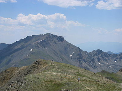 Mount Harvard is the highest of the Collegiate Peaks and the third highest peak of the Rocky Mountains.
 -

-
 Blanca Peak is the highest peak of the Sangre de Cristo Mountains and the second most topographically isolated peak of Colorado.
 -
 Uncompahgre Peak is the highest peak of the San Juan Mountains and the sixth highest peak of the Rocky Mountains.
 -
 Crestone Peak is the highest peak of the Crestones and the seventh highest peak of the Rocky Mountains.
 -
 Mount Lincoln is the highest peak of the Mosquito Range and the eighth highest peak of the Rocky Mountains.
 -
 Castle Peak is the highest peak of the Elk Mountains and the ninth highest peak of the Rocky Mountains.
 -
 Grays Peak is the highest peak of the Front Range, the highest point on the Continental Divide, and the tenth highest peak of the Rocky Mountains.
 -
 Longs Peak is the highest peak in Rocky Mountain National Park and northern Colorado.
 -
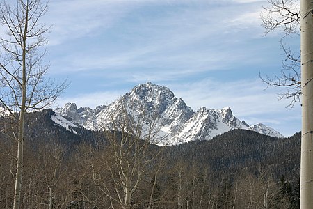 Impressive Mount Sneffels in southwestern Colorado is often said to be the most beautiful mountain in the state.
 -
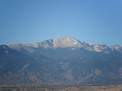 Pikes Peak is the second most topographically prominent mountain summit of Colorado and the easternmost fourteener. The peak sits on top of Pikes Mountain.
 -
 This photograph of the legendary Mount of the Holy Cross was taken by William Henry Jackson in 1874.
 -
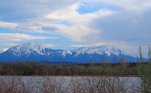 The Spanish Peaks in southern Colorado are two prominent mountains which can be seen for many miles.

_-_2006-07-16.jpg)


See also
[edit]- Bibliography of Colorado
- Geography of Colorado
- History of Colorado
- Index of Colorado-related articles
- List of Colorado-related lists
- Outline of Colorado
Notes
[edit]- ^ This article defines a significant summit as a summit with at least 100 meters (328.1 feet) of topographic prominence, and a major summit as a summit with at least 500 meters (1640 feet) of topographic prominence. All summits in this article have at least 500 meters of topographic prominence. An ultra-prominent summit is a summit with at least 1500 meters (4921 feet) of topographic prominence.
- ^ All elevations in this article include an elevation adjustment from the National Geodetic Vertical Datum of 1929 (NGVD 29) to the North American Vertical Datum of 1988 (NAVD 88). For further information, please see this United States National Geodetic Survey note.
- ^ a b If the elevation or prominence of a summit is calculated as a range of values, the arithmetic mean is shown.
- ^ The topographic prominence of a summit is the topographic elevation difference between the summit and its highest or key col to a higher summit. The summit may be near its key col or quite far away. The key col for Denali in Alaska is the Isthmus of Rivas in Nicaragua, 7642 kilometers (4749 miles) away.
- ^ The topographic isolation of a summit is the great-circle distance to its nearest point of equal elevation.
- ^ This list of the 55 major 4000-meter summits of Colorado includes 30 peaks with more than 500 meters of topographic prominence but less than 4267 meters in elevation: Grizzly Peak, Mount Ouray, Vermilion Peak, Mount Silverheels, Rio Grande Pyramid, Bald Mountain, Mount Oso, Mount Jackson, Bard Peak, West Spanish Peak, Mount Powell, Hagues Peak, Tower Mountain, Treasure Mountain, North Arapaho Peak, Parry Peak, Bill Williams Peak, Sultan Mountain, Mount Herard, West Buffalo Peak, Summit Peak, Middle Peak, Antora Peak, Henry Mountain, Hesperus Mountain, Jacque Peak, Bennett Peak, Conejos Peak, Twilight Peak, and South River Peak.
The list of the 53 Colorado fourteeners includes 28 peaks with over 14,000 feet of elevation but less than 1640 feet of topographic prominence: Torreys Peak, Quandary Peak, Mount Shavano, Mount Belford, Crestone Needle, Mount Bross, Kit Carson Mountain, Tabeguache Peak, Mount Oxford, Mount Democrat, Snowmass Mountain, Windom Peak, Challenger Point, Mount Columbia, Missouri Mountain, Humboldt Peak, Mount Bierstadt, Sunlight Peak, Ellingwood Point, Mount Lindsey, Little Bear Peak, Mount Sherman, Redcloud Peak, Pyramid Peak, Wilson Peak, Wetterhorn Peak, Huron Peak, and Sunshine Peak.
The first 25 summits on this list are included on both lists: Mount Elbert, Mount Massive, Mount Harvard, Blanca Peak, La Plata Peak, Uncompahgre Peak, Crestone Peak, Mount Lincoln, Castle Peak, Grays Peak, Mount Antero, Mount Evans, Longs Peak, Mount Wilson, Mount Princeton, Mount Yale, Maroon Peak, Mount Sneffels, Capitol Peak, Pikes Peak, Mount Eolus, Handies Peak, Culebra Peak, San Luis Peak, and Mount of the Holy Cross.
- ^ a b c The summit of Mount Elbert is the highest point of the U.S. State of Colorado, the Rocky Mountains of North America, and the entire Mississippi River drainage basin.
- ^ Mount Massive is the second highest summit of the Rocky Mountains.
- ^ The elevation of Mount Massive includes an adjustment of +2.087 m (6.85 ft) from NGVD 29 to NAVD 88.
- ^ a b The summit of Mount Harvard is the highest point of the Collegiate Peaks.
- ^ a b Mount Harvard is the southernmost and easternmost summit of its elevation in the Rocky Mountains.
- ^ a b c The summit of Blanca Peak is the highest point of the Sangre de Cristo Mountains and the entire Rio Grande (Rio Bravo del Norte) drainage basin.
- ^ a b c Blanca Peak is the southernmost ultra-prominent summit of the Rocky Mountains.
- ^ a b c The elevation of Blanca Peak includes an adjustment of +1.755 m (5.76 ft) from NGVD 29 to NAVD 88.
- ^ The elevation of La Plata Peak includes an adjustment of +1.983 m (6.51 ft) from NGVD 29 to NAVD 88.
- ^ a b c The summit of Uncompahgre Peak is the highest point of the San Juan Mountains and the entire Gulf of California drainage basin.
- ^ a b c Uncompahgre Peak is the westernmost summit of its elevation in the Rocky Mountains.
- ^ a b c The summit of Crestone Peak is the highest point of the Crestones.
- ^ a b c The elevation of Crestone Peak includes an adjustment of +1.76 m (5.77 ft) from NGVD 29 to NAVD 88.
- ^ a b c The summit of Mount Lincoln is the highest point of the Mosquito Range and the entire Missouri River drainage basin.
- ^ a b c Mount Lincoln is the northernmost summit of its elevation in the Rocky Mountains.
- ^ a b c The summit of Castle Peak is the highest point of the Elk Mountains.
- ^ a b c The summit of Grays Peak is the highest point of the Front Range and the Continental Divide in North America.
- ^ a b c Grays Peak is the northernmost summit of its elevation in the Rocky Mountains.
- ^ a b c The summit of Mount Antero is the highest point of the southern Sawatch Range.
- ^ The summit elevation of Mount Blue Sky includes a vertical offset of +1.798 m (5.9 ft) from the station benchmark.
- ^ a b c The summit of Longs Peak is the highest point of the northern Front Range.
- ^ a b c Longs Peak is the northernmost 14,000-foot (4267-meter) summit of the Rocky Mountains.
- ^ a b c The summit of Mount Wilson is the highest point of the San Miguel Mountains.
- ^ a b c Mount Wilson is the westernmost summit of its elevation in the Rocky Mountains.
- ^ a b c The elevation of Mount Wilson includes an adjustment of +1.899 m (6.23 ft) from NGVD 29 to NAVD 88.
- ^ a b c The summit of Mount Sneffels is the highest point of the Sneffels Range.
- ^ The elevation of Capitol Peak includes an adjustment of +1.991 m (6.53 ft) from NGVD 29 to NAVD 88.
- ^ a b The summit of Windom Peak is the highest point of the Needle Mountains.
- ^ a b Mount Eolus may be higher than Windom Peak.
- ^ a b The elevation of Windom Peak includes an adjustment of +1.785 m (5.86 ft) from NGVD 29 to NAVD 88.
- ^ a b c The summit of Culebra Peak is the highest point of the Culebra Range.
- ^ a b c Culebra Peak is the southernmost 14,000-foot (4267-meter) summit of the Rocky Mountains.
- ^ a b c The elevation of Culebra Peak includes an adjustment of +1.74 m (5.71 ft) from NGVD 29 to NAVD 88.
- ^ a b The summit of Mount of the Holy Cross is the highest point of the northern Sawatch Range.
- ^ a b The summit elevation of Mount of the Holy Cross includes a vertical offset of +0.61 m (2 ft) from the station benchmark.
- ^ Grizzly Peak lies on the Continental Divide of the Americas.
- ^ a b c The summit of Mount Ouray is the highest point of the far southern Sawatch Range.
- ^ The elevation of Vermilion Peak includes an adjustment of +1.827 m (5.99 ft) from NGVD 29 to NAVD 88.
- ^ The elevation of Bald Mountain includes an adjustment of +1.922 m (6.31 ft) from NGVD 29 to NAVD 88.
- ^ The elevation of Mount Oso includes an adjustment of +1.776 m (5.83 ft) from NGVD 29 to NAVD 88.
- ^ The elevation of Bard Peak includes an adjustment of +1.707 m (5.6 ft) from NGVD 29 to NAVD 88.
- ^ a b c The elevation of West Spanish Peak includes an adjustment of +1.468 m (4.82 ft) from NGVD 29 to NAVD 88.
- ^ a b c The summit of Mount Powell is the highest point of the Gore Range.
- ^ a b c The elevation of Mount Powell includes an adjustment of +1.771 m (5.81 ft) from NGVD 29 to NAVD 88.
- ^ a b c The summit of Hagues Peak is the highest point of the Mummy Range.
- ^ The elevation of Tower Mountain includes an adjustment of +1.796 m (5.89 ft) from NGVD 29 to NAVD 88.
- ^ a b The elevation of Treasure Mountain includes an adjustment of +2.008 m (6.59 ft) from NGVD 29 to NAVD 88.
- ^ a b The summit of North Arapaho Peak is the highest point of the Indian Peaks.
- ^ a b The elevation of North Arapaho Peak includes an adjustment of +1.763 m (5.78 ft) from NGVD 29 to NAVD 88.
- ^ The elevation of Parry Peak includes an adjustment of +1.763 m (5.78 ft) from NGVD 29 to NAVD 88.
- ^ The summit of Bill Williams Peak is the highest point of the Williams Mountains.
- ^ The elevation of Bill Williams Peak includes an adjustment of +2.044 m (6.71 ft) from NGVD 29 to NAVD 88.
- ^ The elevation of Sultan Mountain includes an adjustment of +1.649 m (5.41 ft) from NGVD 29 to NAVD 88.
- ^ The elevation of Mount Herard includes an adjustment of +1.64 m (5.38 ft) from NGVD 29 to NAVD 88.
- ^ The elevation of West Buffalo Peak includes an adjustment of +1.834 m (6.02 ft) from NGVD 29 to NAVD 88.
- ^ a b c The summit of Summit Peak is the highest point of the southern San Juan Mountains.
- ^ Dolores Peak may be higher than Middle Peak.
- ^ The elevation of Middle Peak includes an adjustment of +1.809 m (5.94 ft) from NGVD 29 to NAVD 88.
- ^ a b The elevation of Antora Peak includes an adjustment of +1.883 m (6.18 ft) from NGVD 29 to NAVD 88.
- ^ The elevation of Henry Mountain includes an adjustment of +2.037 m (6.68 ft) from NGVD 29 to NAVD 88.
- ^ a b c The summit of Hesperus Mountain is the highest point of the La Plata Mountains.
- ^ a b c The elevation of Hesperus Mountain includes an adjustment of +1.65 m (5.41 ft) from NGVD 29 to NAVD 88.
- ^ The elevation of Jacque Peak includes an adjustment of +1.866 m (6.12 ft) from NGVD 29 to NAVD 88.
- ^ a b The elevation of Bennett Peak includes an adjustment of +1.782 m (5.85 ft) from NGVD 29 to NAVD 88.
- ^ The summit of Twilight Peak is the highest point of the West Needle Mountains.
- ^ The elevation of Twilight Peak includes an adjustment of +1.537 m (5.04 ft) from NGVD 29 to NAVD 88.
- ^ a b The summit of Flat Top Mountain is the highest point of the Flat Tops.
- ^ a b The summit of Ute Peak is the highest point of Ute Mountain.
- ^ a b The summit of Greenhorn Mountain is the highest point of the Wet Mountains.
- ^ a b The summit of Mount Zirkel is the highest point of the Park Range.
- ^ a b The elevation of Mount Zirkel includes an adjustment of +1.632 m (5.35 ft) from NGVD 29 to NAVD 88.
- ^ a b The summit of San Luis Peak is the highest point of the La Garita Mountains.
- ^ a b The summit of West Elk Peak is the highest point of the West Elk Mountains.
- ^ The elevation of Huntsman Ridge Peak includes an adjustment of +1.711 m (5.61 ft) from NGVD 29 to NAVD 88.
- ^ a b The elevation of Castle Peak includes an adjustment of +1.575 m (5.17 ft) from NGVD 29 to NAVD 88.
- ^ a b The elevation of Diamond Peak includes an adjustment of +1.436 m (4.71 ft) from NGVD 29 to NAVD 88.
- ^ a b The summit of Clark Peak is the highest point of the Medicine Bow Mountains.
- ^ The summit elevation of Mount Evans includes a vertical offset of +1.798 m (5.9 ft) from the station benchmark.
- ^ The elevation of Marcellina Mountain includes an adjustment of +1.658 m (5.44 ft) from NGVD 29 to NAVD 88.
- ^ The summit of Mount Richthofen is the highest point of the Never Summer Mountains.
- ^ The elevation of Mount Richthofen includes an adjustment of +1.658 m (5.44 ft) from NGVD 29 to NAVD 88.
- ^ a b The elevation of Piñon Mesa HP includes an adjustment of +1.408 m (4.62 ft) from NGVD 29 to NAVD 88.
- ^ The summit of Parkview Mountain is the highest point of the Rabbit Ears Range.
- ^ The elevation of Crested Butte includes an adjustment of +1.94 m (6.36 ft) from NGVD 29 to NAVD 88.
- ^ a b The summit of Bison Mountain is the highest point of the Tarryall Mountains.
- ^ a b The elevation of Black Mountain includes an adjustment of +1.537 m (5.04 ft) from NGVD 29 to NAVD 88.
- ^ The elevation of East Spanish Peak includes an adjustment of +1.372 m (4.5 ft) from NGVD 29 to NAVD 88.
- ^ The summit of Fishers Peak is the highest point of Raton Mesa.
- ^ Fishers Peak is the easternmost summit of its elevation in the Rocky Mountains and the United States.
- ^ The summit of Waugh Mountain is the highest point of the South Park Hills.
- ^ The elevation of Waugh Mountain includes an adjustment of +1.702 m (5.58 ft) from NGVD 29 to NAVD 88.
- ^ The summit of Crater Peak is the highest point of Grand Mesa.
- ^ The summit of Sand Mountain North is the highest point of the Elkhead Mountains.
- ^ The elevation of Sand Mountain North includes an adjustment of +1.502 m (4.93 ft) from NGVD 29 to NAVD 88.
- ^ The elevation of Mount Mestas includes an adjustment of +1.372 m (4.5 ft) from NGVD 29 to NAVD 88.
- ^ The elevation of Archuleta Mesa includes an adjustment of +1.351 m (4.43 ft) from NGVD 29 to NAVD 88.
- ^ The elevation of Horse Mountain includes an adjustment of +1.461 m (4.79 ft) from NGVD 29 to NAVD 88.
References
[edit]- ^ a b c "MOUNT ELBERT". Datasheet for NGS Station KL0637. U.S. National Geodetic Survey. Retrieved 18 May 2016.
- ^ a b c "Mount Elbert". Geographic Names Information System. United States Geological Survey, United States Department of the Interior.
- ^ a b c "Mount Elbert". Peakbagger.com. Retrieved 18 May 2016.
- ^ a b c "Mount Elbert". Bivouac.com. Retrieved 18 May 2016.
- ^ "MOUNT MASSIVE CAIRN". Datasheet for NGS Station KL0640. U.S. National Geodetic Survey. Retrieved 18 May 2016.
- ^ "Mount Massive". Geographic Names Information System. United States Geological Survey, United States Department of the Interior.
- ^ "Mount Massive". Peakbagger.com. Retrieved 18 May 2016.
- ^ "Mount Massive". Bivouac.com. Retrieved 18 May 2016.
- ^ a b "HARVARD". Datasheet for NGS Station JL0879. U.S. National Geodetic Survey. Retrieved 18 May 2016.
- ^ a b "Mount Harvard". Geographic Names Information System. United States Geological Survey, United States Department of the Interior.
- ^ a b "Mount Harvard". Peakbagger.com. Retrieved 18 May 2016.
- ^ a b "Mount Harvard". Bivouac.com. Retrieved 18 May 2016.
- ^ a b c "Blanca Peak". Geographic Names Information System. United States Geological Survey, United States Department of the Interior.
- ^ a b c "Blanca Peak". Peakbagger.com. Retrieved 18 May 2016.
- ^ a b c "Blanca Peak". Bivouac.com. Retrieved 18 May 2016.
- ^ "La Plata Peak". Geographic Names Information System. United States Geological Survey, United States Department of the Interior.
- ^ "La Plata Peak". Peakbagger.com. Retrieved 18 May 2016.
- ^ "La Plata Peak". Bivouac.com. Retrieved 18 May 2016.
- ^ a b c "UNCOMPAHGRE". Datasheet for NGS Station JL0798. U.S. National Geodetic Survey. Retrieved 18 May 2016.
- ^ a b c "Uncompahgre Peak". Geographic Names Information System. United States Geological Survey, United States Department of the Interior.
- ^ a b c "Uncompahgre Peak". Peakbagger.com. Retrieved 18 May 2016.
- ^ a b c "Uncompahgre Peak". Bivouac.com. Retrieved 18 May 2016.
- ^ a b c "Crestone Peak". Geographic Names Information System. United States Geological Survey, United States Department of the Interior.
- ^ a b c "Crestone Peak". Peakbagger.com. Retrieved 18 May 2016.
- ^ a b c "Crestone Peak". Bivouac.com. Retrieved 18 May 2016.
- ^ a b c "MT LINCOLN". Datasheet for NGS Station KL0627. U.S. National Geodetic Survey. Retrieved 18 May 2016.
- ^ a b c "Mount Lincoln". Geographic Names Information System. United States Geological Survey, United States Department of the Interior.
- ^ a b c "Mount Lincoln". Peakbagger.com. Retrieved 18 May 2016.
- ^ a b c "Mount Lincoln". Bivouac.com. Retrieved 18 May 2016.
- ^ a b c "CASTLE PK". Datasheet for NGS Station KL0659. U.S. National Geodetic Survey. Retrieved 18 May 2016.
- ^ a b c "Castle Peak". Geographic Names Information System. United States Geological Survey, United States Department of the Interior.
- ^ a b c "Castle Peak". Peakbagger.com. Retrieved 18 May 2016.
- ^ a b c "Castle Peak". Bivouac.com. Retrieved 18 May 2016.
- ^ a b c "GRAYS PEAK". Datasheet for NGS Station KK2036. U.S. National Geodetic Survey. Retrieved 18 May 2016.
- ^ a b c "Grays Peak". Geographic Names Information System. United States Geological Survey, United States Department of the Interior.
- ^ a b c "Grays Peak". Peakbagger.com. Retrieved 18 May 2016.
- ^ a b c "Grays Peak". Bivouac.com. Retrieved 18 May 2016.
- ^ a b c "MT ANTERO". Datasheet for NGS Station JL0883. U.S. National Geodetic Survey. Retrieved 18 May 2016.
- ^ a b c "Mount Antero". Geographic Names Information System. United States Geological Survey, United States Department of the Interior.
- ^ a b c "Mount Antero". Peakbagger.com. Retrieved 18 May 2016.
- ^ a b c "Mount Antero". Bivouac.com. Retrieved 18 May 2016.
- ^ "EVANS". Datasheet for NGS Station KK2030. U.S. National Geodetic Survey. Retrieved 18 May 2016.
- ^ "Mount Blue Sky". Geographic Names Information System. United States Geological Survey, United States Department of the Interior.
- ^ "Mount Blue Sky". Peakbagger.com. Retrieved 18 May 2016.
- ^ "Mount Blue Sky". Bivouac.com. Retrieved 18 May 2016.
- ^ a b c "LONGS PEAK". Datasheet for NGS Station LL1346. U.S. National Geodetic Survey. Retrieved 18 May 2016.
- ^ a b c "Longs Peak". Geographic Names Information System. United States Geological Survey, United States Department of the Interior.
- ^ a b c "Longs Peak". Peakbagger.com. Retrieved 18 May 2016.
- ^ a b c "Longs Peak". Bivouac.com. Retrieved 18 May 2016.
- ^ a b c "Mount Wilson". Geographic Names Information System. United States Geological Survey, United States Department of the Interior.
- ^ a b c "Mount Wilson". Peakbagger.com. Retrieved 18 May 2016.
- ^ a b c "Mount Wilson". Bivouac.com. Retrieved 18 May 2016.
- ^ "PRINCETON". Datasheet for NGS Station JL0886. U.S. National Geodetic Survey. Retrieved 18 May 2016.
- ^ "Mount Princeton".